2.4 Creating a Scale
Applications
In Section 2.1, we mentioned the hazards of printing a map off when you don’t know the size it was created at. So, what can we do in that situation?
You need to know two things to create a scale for any map: A distance measured on the ground, and the same distance as it’s represented on the map.
To find or create the scale follow the steps here:
- Find the distance on the ground. You may have measured this in the field with an odometer or tape – or it may be information you have gathered from other sources (notes on an existing map, online information, etc.).
- Measure that distance on the map – or – decide how large you want that feature to be on a map you’re creating.
- Convert the measurements into the same units. It’s usually easier to run calculations if you convert the ground distance measurement into inches or centimeters.
- Put the map distance (MD) over the ground distance (GD) and divide each by the map distance. This will give you an MD of one so that the scale is in the customary representative fraction format (1: XXXX).
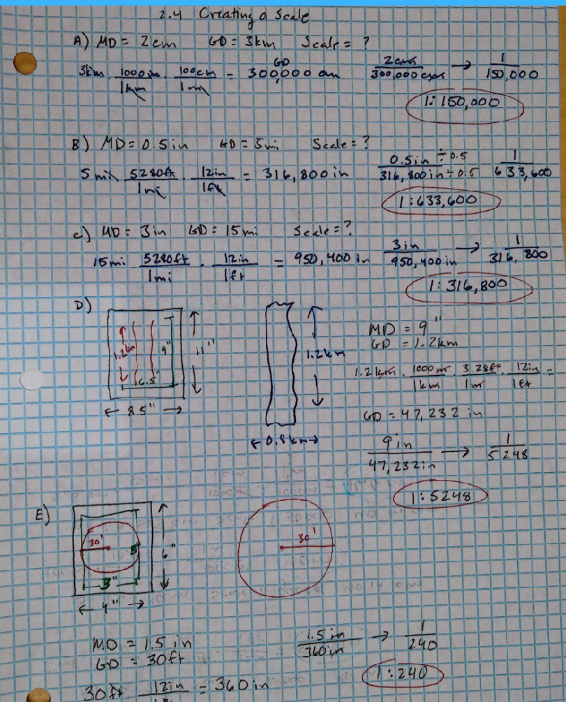
Examples: Finding the Scale
A) MD = 2 cm GD = 3 km Scale = ?
B) MD = 0.5 in GD = 5 mi Scale = ?
C) You’ve printed a map out, but aren’t sure if the scale is correct at this size. On the map, the distance between Cheney and Spokane is 3 inches. On the ground the distance is 15 miles. What is the scale of this map?
D) You need to create a sketch map of your field site. The site measures 1.2 km by 0.8 km. You have a standard 8.5″ x 11″ sheet of paper to make the map on. You’d like a margin of one-inch on each side of the paper. If you want the field site to be shown as large as possible on this sheet of paper, what will the scale be?
E) Your vegetation plot is circular with a radius of 30 feet. What should the scale be if you want to make the plot as large as possible on a 6″ x 4″ sheet of paper with a half-inch margin?
Problem Set 2.4
- I have just been given a map to a new field site; however, the scale has been torn off. I see Craggy Lodge on the map and a trailhead that is 5 miles away on the ground. On the map, the distance between the lodge and the trailhead is 2 inches. What is the scale of this map shown as a representative fraction?
- I have an ortho photo without a scale. I know the distance between road 1771 and Green Lake is 0.5 mile. On the photo this distance measures as 2.2 inches. What is the scale of my photo?
- I have part of a map. I know the distance between Tiptoe Peak and Mt. Baldy is 7 km. On the map it measures as 8 cm. What is the scale of my map?
- I have a map with a scale of 1” = 4 miles; however I can tell the map has been reduced (the font is almost too small to read). I know the distance between Spokane and Coeur d’Alene is 35 miles. This distance measures at 2.5 inches on the map. What is the scale of my map now?
- I have an old treasure map. I know the distance between Pelican Island and Rum Cove is 400 yards. If this distance is 3.8 cm on my map, what is the map’s scale?
- I have a little field notebook with pages that are 13 cm x 18 cm. I want to make a sketch map of my vegetation plot. The plot is 5 m X 1 m. If I want to leave a 1 cm margin on all sides, what scale should I use?
- I have a sheet of tracing paper (velum) that is 11 in x 17 in. I want to make a sketch map of a stream restoration I am planning. The area to map is 800 feet by 300 feet. If I want to leave a 1 inch margin on all sides, what scale should I use?
- I need to map a circular plot. The diameter of my plot is 15 feet. I have a piece of 8.5”x11” paper. If I want the edge of my plot to just touch the edge of the paper, what scale will I use to map this plot?
