2.1 Types of Scales
Applications
Have you ever been to Silverwood or another theme park? You'll usually get a map of the park when you enter. Take a look at the map below, if you're at the entrance, how far will the walk to the Tremors Coaster be?
What do you need to know to figure out how far that walk will be?
A map is a visual representation of the physical world. The scale connects the symbolized world of the map to the spaces we move in. It depicts the ratio of distances on the map (map distance or MD) to distances on the ground (ground distance or GD).
There are three main ways map scales are shown:
- Verbal scale: This spells things out in words, like "one inch equals 10 miles." This is easy to understand, but not as precise for measuring distances on the map itself. This type of scale works fine for small area maps used by the general public. For example, a map of an amusement park or a diagram of a store might use a verbal scale.
- Graphic scale: This is a bar on the map divided into segments representing real-world distances. It's useful for quickly measuring distances on the map without having to do any math. Graphic scales work well if precision isn't needed. They can also be convenient for quickly "eyeballing" a distance.
- Representative fraction scale: Written as a ratio like 1:100,000. In this example, 1 unit (inch, centimeter, etc.) on the map corresponds to 100,000 of the same units on the ground. So, if the scale is 1:100,000, one centimeter on the map equals 100,000 centimeters, or 1 kilometer, in the real world. The bigger the second number in the ratio, the smaller the scale, which means a larger area is shown on a smaller map. A map of a whole continent will have a much smaller scale (like 1:100,000,000) than a city map (which might be 1:25,000). A representative fraction scale allows us to calculate precise distances from the map to the ground and vice versa. When we are using a map to navigate precision is important!
Verbal scales and representative fraction scales are vulnerable to being shrunk or enlarged. If you print a map off that you found online, be warned. The scale is likely not correct unless you are certain you printed it at the same size it was created. A graphic scale will be valid whatever size you use the map at - but it's difficult to calculate precise distances with a graphic scale.
When we use a map for navigation on the job, it should have a representative fraction scale and a graphic scale.
Using both scale types allows us to calculate precise distances and have a "back up" scale if the map is enlarged or reduced. Maps that are meant for display (not navigation) can get away with just a representative fraction scale.
We're going to learn how to use a representative fraction scale to calculate ground distances and areas from map distances and how to find a distance on the map if we know it on the ground.
A representative fraction scale can be written in a few ways. In each, the first number or numerator stands for the map distance (MD), and the second number or denominator stands for the ground distance (GD).
- [latex]MD:GD[/latex] for example [latex]1:24000[/latex]
- [latex]\frac{MD}{GD}[/latex] for example [latex]\frac{1}{24000}[/latex]
- [latex]MD = GD[/latex] for example [latex]1= 24000[/latex]
- MD to GD for example 1 to 24000
So, if MD = GD, then is [latex]\frac{MD}{GD}= 1[/latex] ?
Yes!
Can we use a map scale the same way we use a conversion factor?
Yes!
Do I already have the skills I need to work with map scales?
Pretty much, yes!
Representative fraction scales have no units. So, we can use whatever units we need to with them as long as the units for map distance are the same as the units for ground distance.
To convert a verbal scale to a representative fraction:
- Get the units to match.
- Divide the numerator and the denominator by the numerator (map distance).
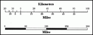
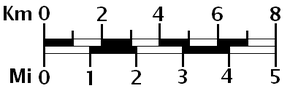
To convert a graphic scale to a representative fraction:
- Measure the bar. This is your map distance (MD).
- Find the distance this represents on the ground. It's usually written above the bar. This is your ground distance (GD).
- Now, get the units to match and use the steps for a verbal scale given above.
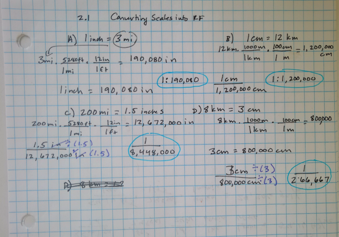
Examples: Converting Other Scales Into Representative Fraction
A) 1 inch equals 3 miles B) 1 cm = 12 km
C)
D)
Problem Set 2.1
- The scale on your theme park map says 1 inch = 300 yards. What is this scale as a representative fraction?
- You measure the bar scale on your map at [latex]1 \frac{3}{8}[/latex] inch and the bar says this represents 200 miles. What is the representative fraction scale?
- Challenge: If your map is at a scale of 1:24000, how many miles does one inch represent?
