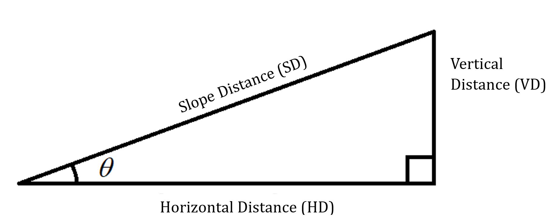
8.7 Right Triangle Applications
Applications
Here’s an age-old forestry problem: How tall is this tree?
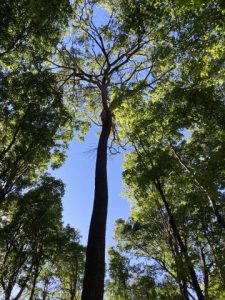
The Hendricks Creek survivor elm stands on lands managed by the Wisconsin Board of Commissioners of Public Lands in northern Wisconsin. USDA Forest Service photo by Linda Haugen.
What do you need to know to find the height of this tree? How could you collect that data? What tools would you need? What about measuring the height of the tree if you are standing on a slope? We’ll apply right triangles to this situation and many others!
Instruments for Measuring Angles
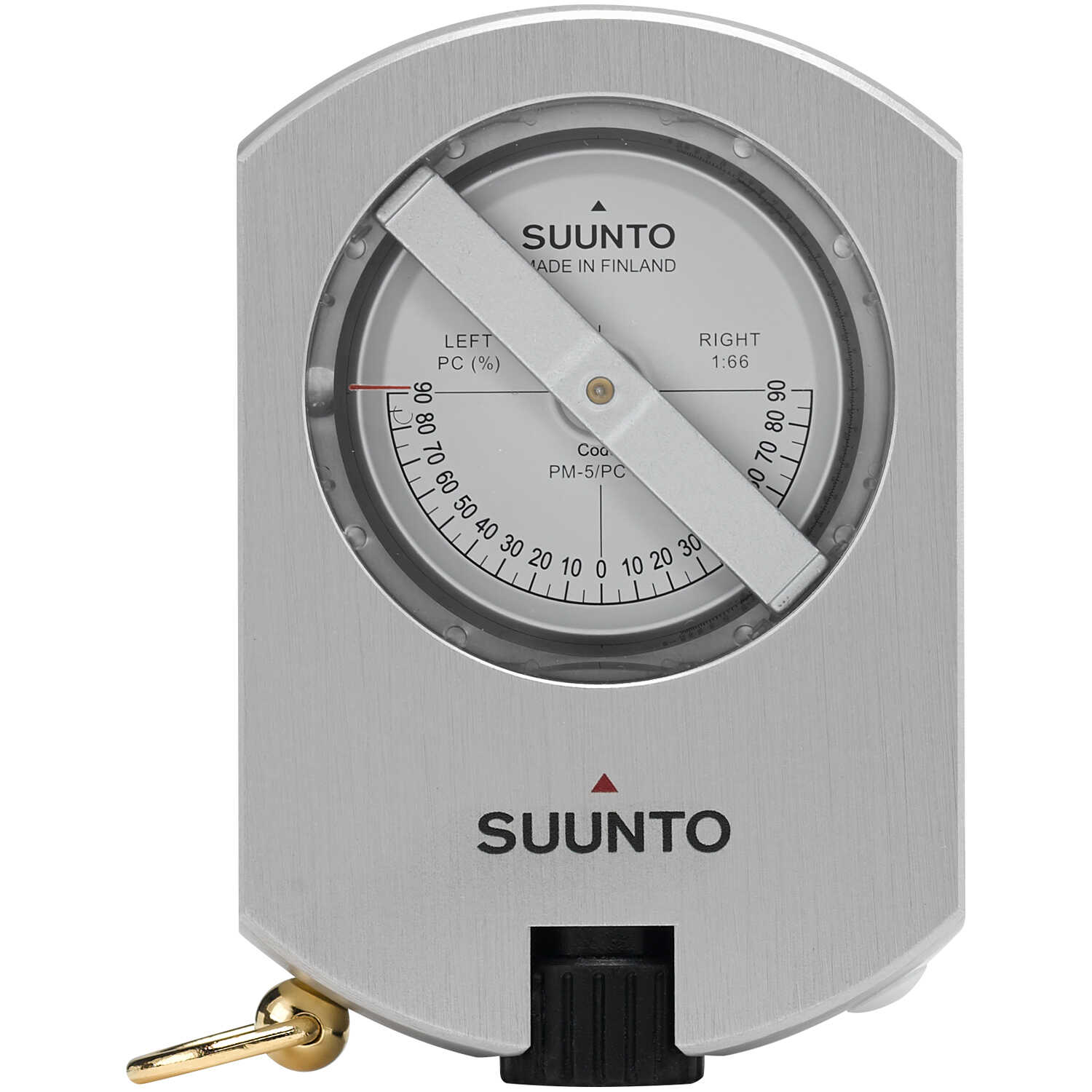
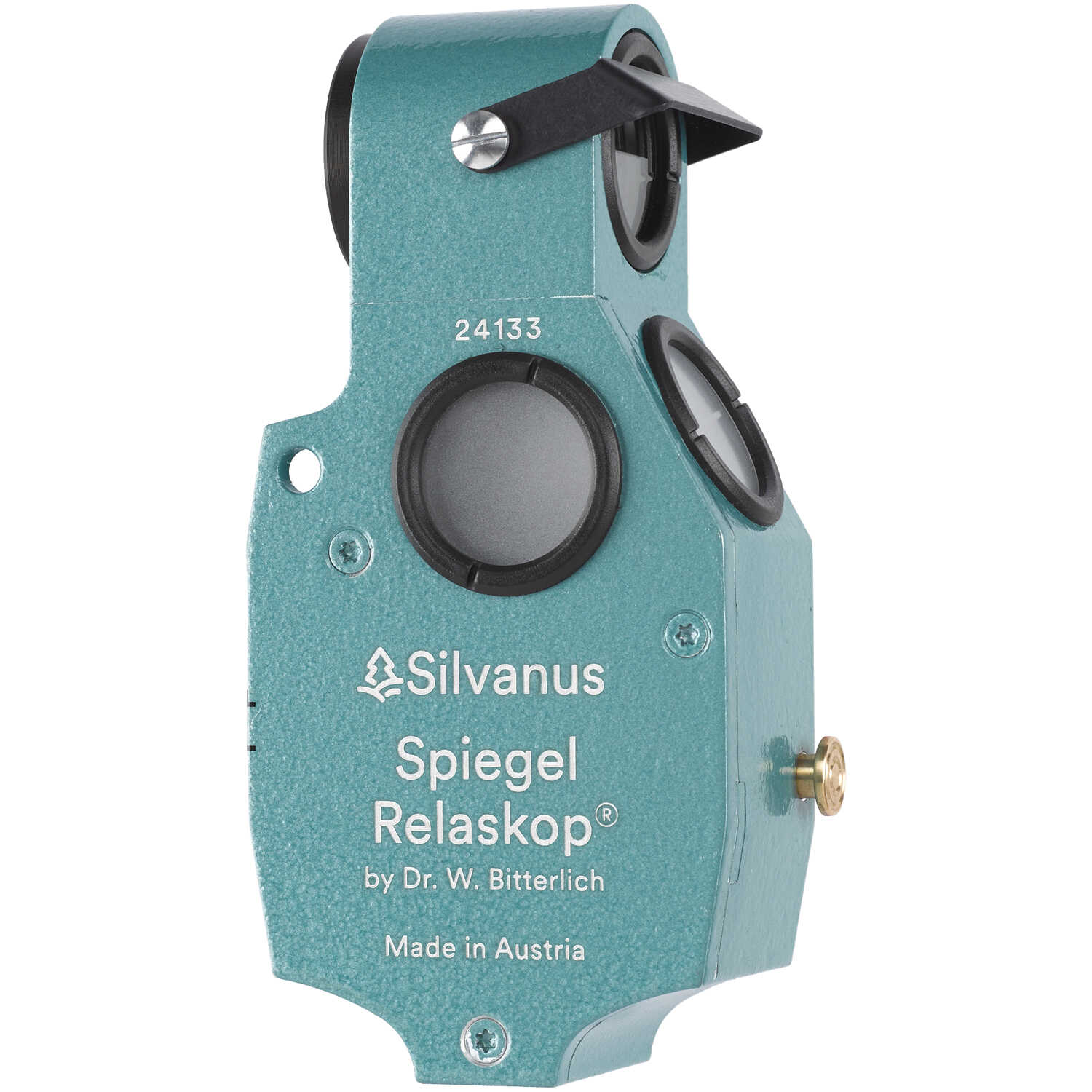
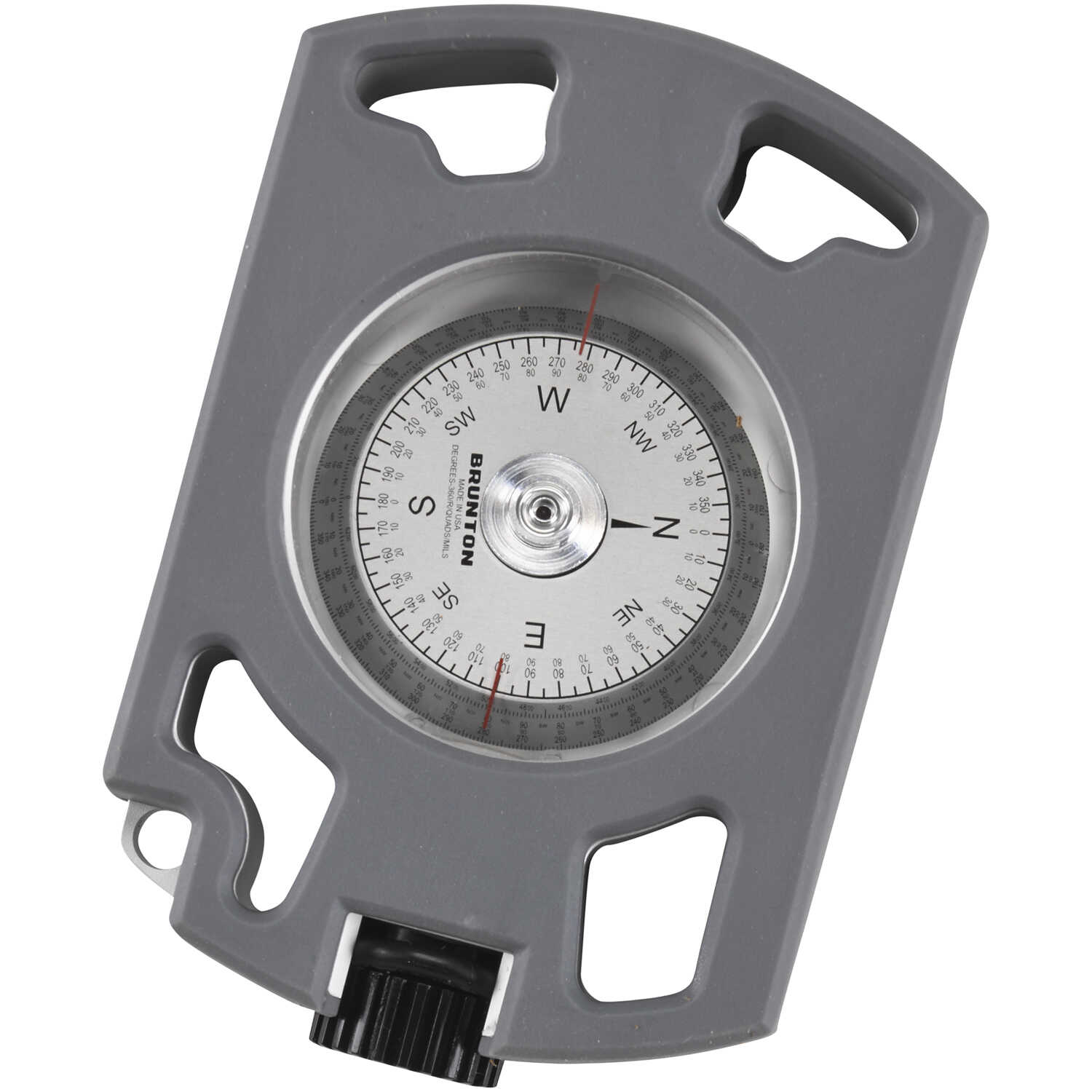
Outside of a surveying environment, we’ll generally use a clinometer or relaskop to measure vertical angles (up and down) and a compass to measure horizontal angles (back and forth). A clinometer will have two scales – one in percent and another in degrees or topographic. We’ll use the percent or topographic scale when measuring slopes and heights because the calculations can be done in your head.
Slopes
Soon enough, you’ll learn how to measure the slope angle using a clinometer or relaskop in the field!
Slopes on maps
What if you’re presented with a topographic map and asked to find the slope? The distance you measure on the map represents the horizontal distance of the slope triangle (after you have converted it from the map distance to a ground distance). If you were to walk that same path on the ground, you’d be walking the slope distance.
 You’ll find the slope angle of a map segment using [latex]{\text{Slope Angle in Percent}} = \frac{VD}{HD} * 100[/latex], where the the vertical distance (VD) is the number of contour lines crossed by that segment multiplied by the contour interval – and the horizontal distance is the ground distance along the segment.
Examples: Slope on a Topographic Map
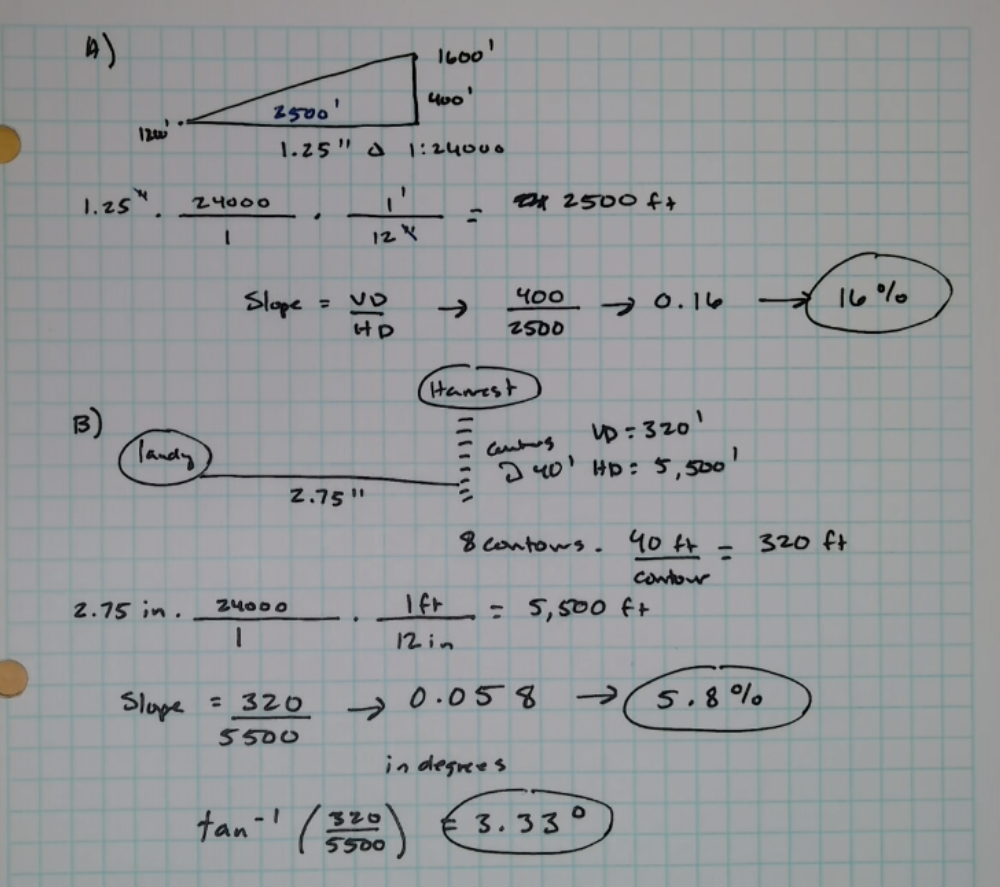
A) Point A is at 1200′ and Point B is at 1600′. The distance between them on a 1:24000 scale map is 1.25 inches. What is the slope between these points in percent?
B) Your 1:24000 – scale map has contour lines at 40′ intervals. If you count 8 contour lines between the landing and your harvest area and the distance is 2.75 inches, what is the average slope between these areas? In percent? In degrees?
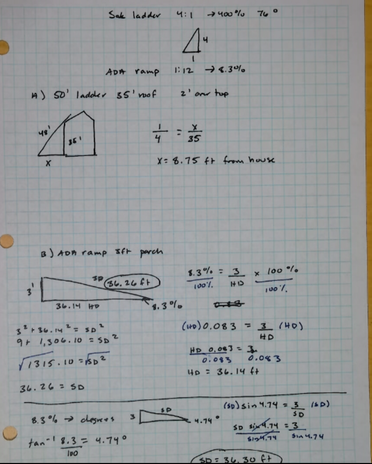
Slopes for Ladders and Ramps
We’ll see several situations where calculating the slope angle is needed given two of the sides of the slope triangle. In these cases, you’ll likely have a slope angle that you need to stay below or above for safety or accessibility. For example, a ladder is set up for optimal safety if its vertical distance is four times the horizontal distance it lies from the base of the object being climbed (400% slope or about 76°).
To meet accessibility requirements under the Americans with Disabilities Acts (ADA), ramps need to have a slope ratio of 1:12 (8.3%) or less and are limited to a maximum horizontal distance of 30 feet.
Examples: Ladders and Ramps
A) My ladder is 50′ tall. How far should I place it from the building to access a 35′ tall roof if I leave 2 feet of ladder over the top of the roof so that I can climb off safely?
B) How long does my ramp need to be to meet ADA criteria while reaching a porch that’s 3′ high?
Slopes for Trails
On a trail, the distance you walk is the slope distance (SD), and it’s the hypotenuse of the slope triangle. The horizontal distance (HD) is the distance measured on a map and the vertical distance (VD) is the difference between your starting and finishing elevations.
The Forest Service has developed guidelines for ADA accessible trails that include the following parameters:
- 1:20 (5 percent) for any distance
- 1:12 (8.33 percent) for up to 200 feet (61 meters)
- 1:10 (10 percent) for up to 30 feet (9 meters)
- 1:8 (12.5 percent) for up to 10 feet (3 meters)
- 1:7 (14 percent) into and out of drain dips for up to 5 feet (1.5 meters) where the cross slope does not exceed 1:10
- Cross slopes should not exceed 1:20 (5 percent)

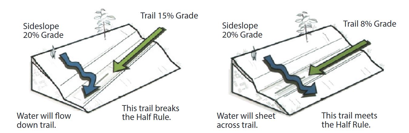
Trails built with a grade less than half the side slope (slope of the hillside the trail traverses) are more resistant to erosion. In general, trails with an average slope greater than 40% are considered extremely challenging.
 Given these parameters, we can design trails over a variety of terrain!
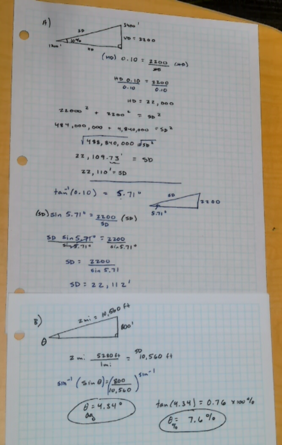
Examples: Trails and Slope
A) You want your trail to maintain an average slope of 10% while it climbs from a base elevation of 1,200 feet to a peak at 3,400 feet. How long will the trail need to be to maintain this average slope?
B) What is the average slope of a trail that gains 800 feet over a walked distance of 2 miles?
Heights
Let’s leave the world of slope for a moment to examine how we can use our distance from a tall object (like a tree) and the angles to the top and the bottom of the object to find its height.
Measurements in Degrees
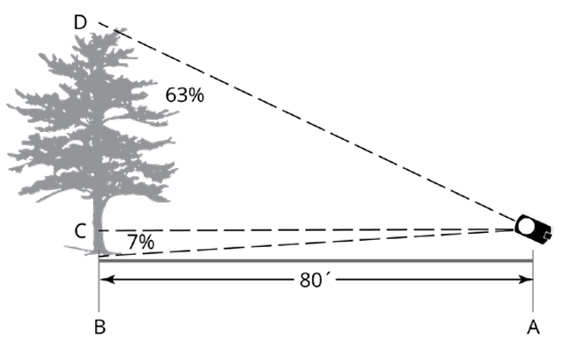
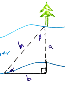
Check out the sweet triangle we can make with a tree! Which parameters can we measure easily in the field?
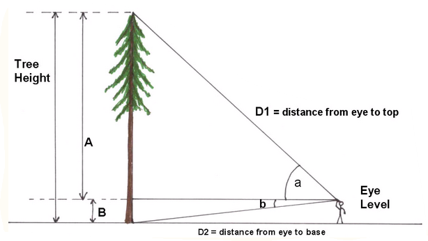
On flat ground, if you’ve got the angle to the top of an object, the angle to the bottom of an object, and you know your distance from the object – you can build a couple of straightforward triangles.
The tangent of α will be height A divided by length D1 (the horizontal distance HD). So, we can find height A by multiplying the tangent α by the distance from the tree, and we can find height B by multiplying the tangent β by the distance from the tree (HD). So, the total height of the tree (A+B) is equal to:
[latex]Height = HD(\tan\alpha)+HD(\tan\beta)[/latex]
Simplified
[latex]Height = HD(\tan\alpha +\tan\beta)[/latex]
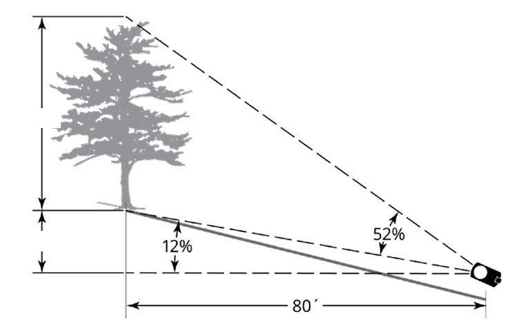
Measurements in Percent
Measurements in percent are straightforward. Stand at a convenient distance, sight the top of the object and read the % scale (%T). Sight the bottom of the object and read the % scale (%B). Subtract the bottom reading from the top reading and multiply by your horizontal distance from the object.
[latex]Height= (%T-%B)*HD[/latex]
Examples: Heights of Objects
Heights on a Slope
When we measure trees in the field, we’ll usually be standing on a slope (at least in this part of the world!). The distance that we measure by pulling a tape or pacing chains will be a slope distance (SD). We can get the slope angle with a clinometer. We can also get the angle to the top of a tree and the angle to the bottom of a tree with a clinometer.
Measurements in Degrees
If we are working in degrees, how can we put these measurements together to arrive at the tree’s height?
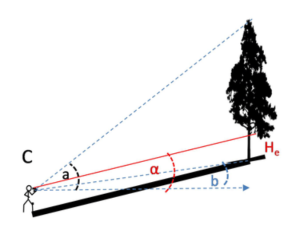
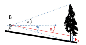
Our first step is to get our horizontal distance from the tree. We can derive this from the slope distance (that we measured by pacing or pulling a tape/chain) and the slope angle (that we measured using a clinometer or similar tool).
[latex]\text{Horizontal Distance} = \text{Slope Distance}\cdot \text{Cos}(\text{slope angle})[/latex]
Then, we can calculate the total height of the tree by using the angles we measured to its top and bottom.
[latex]\text{Tree Height}= \text{Horizontal Distance}\cdot (\text{Tan (angle to top) - Tan (angle to bottom)})[/latex]
We can put these together into one equation.
[latex]\text{Tree Height}={\text{Slope Distance}\cdot \text{Cos}(\text{slope angle})}\cdot (\text{Tan (angle to top) - Tan (angle to bottom)})[/latex]
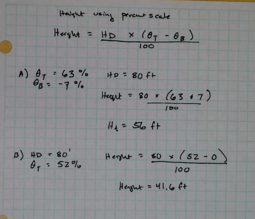
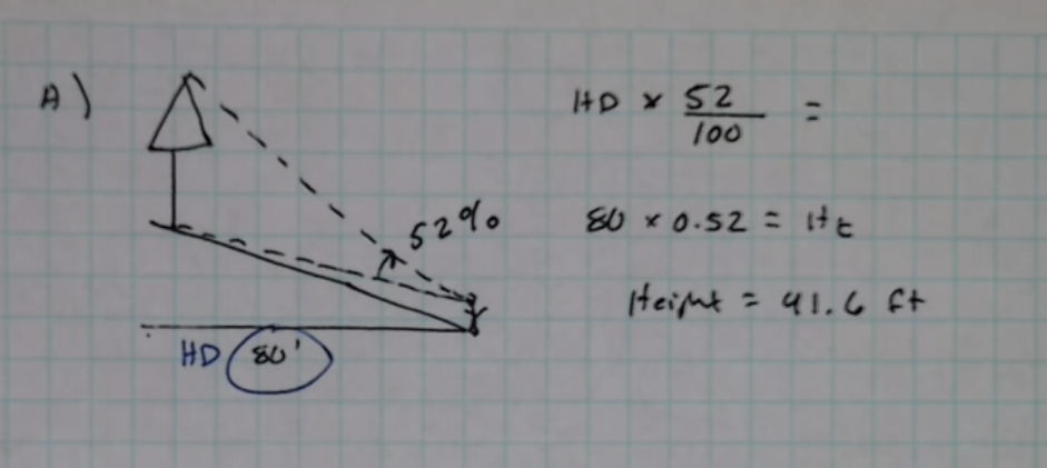
Measurements in Percent
When measuring in the height of an object using the percent scale, find the horizontal distance from the object.
[latex]HD = SD * \cos(\tan^{-1} \frac{slope}{100})[/latex]
Use this in the calculation for height.
[latex]\text{Height}= (\text{%Top -%Bottom})\cdot \text{Horizontal Distance}[/latex]
The formulas can also be combined into one calculation.
[latex]\text{Height} =SD * \cos(\tan^{-1} \frac{slope}{100}) \ast (\text{%Top -%Bottom})[/latex]
Forest Measurements by Joan DeYoung has a great discussion and explanation of the arithmetic for working with percent slope!
Examples: Heights on Slopes
Gaps
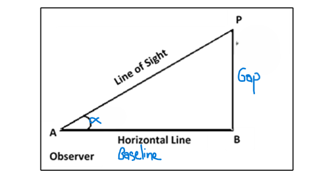
You’re on one side of a river (or a canyon, or a swampy muskeg, or a busy highway) and need to know the distance to the other side. Right triangles can help and it’s like surveying magic!
You’ll need to know one of the legs of the triangle and one of the angles. Which ones can you readily measure?
Use a tape to measure the distance you walk from the object you sighted on the other side to the point you’ll sight back to the object (side b). Use a compass to measure angle α. Viola! You have an angle and a side of a right triangle. Use these to find side a.
[latex]Gap (a) = baseline (b)* \tan\alpha[/latex]
(In this particular diagram, you’d need to subtract the distance you stood from the river’s edge to get the width of the river.)
In general, we call side b the baseline and angle α is our “angle to point“.
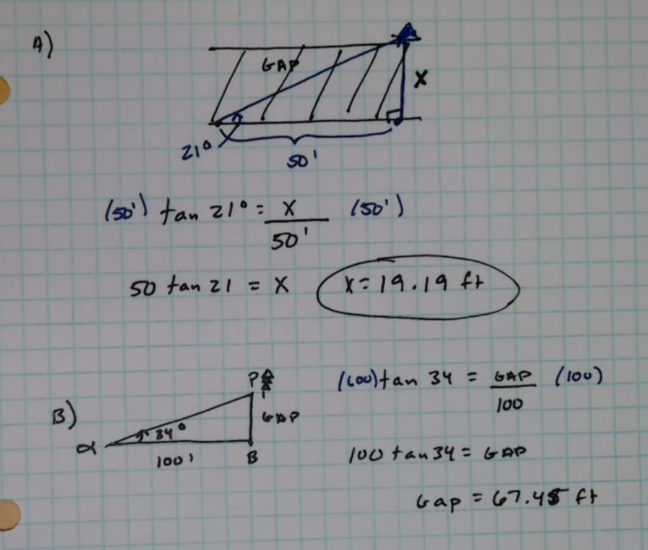
Examples: Measuring Across Gaps
A) I’m measuring across a gap. I set up a baseline of 50′ and measure α an “angle to point” back to the object I sighted on as 21°. What is the distance across the gap?
B) The gap in this sketch is a canyon. Point P is a giant pine on the other side. Your baseline is 100 feet and your angle to point (α) is 34°. What is the distance across the canyon?
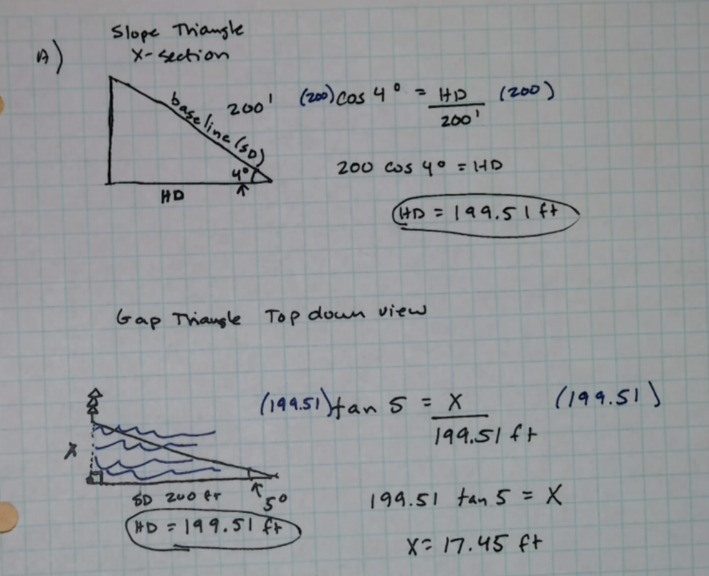
Gaps on a Slope
If you’re working on a slope and measuring across a gap, you’ll need to correct for the slope to find the true baseline before running your calculations. To find the accurate baseline use [latex]HD = SD * \cos(\tan^{-1} \frac{slope}{100})[/latex] if you measured slope in percent and [latex]\text{Horizontal Distance} = \text{Slope Distance}\cdot \text{Cos}(\text{slope angle})[/latex] if you measured slope in degrees.
Examples: Measuring Across Gaps on a Slope
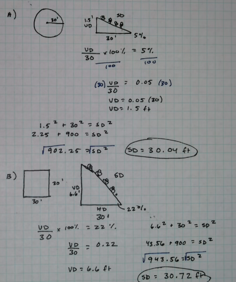
Plots on a Slope
Similarly, when you are putting in plots, you’ll use the corrected horizontal distance if you are measuring up or down the slope. The distance you measure on the ground along the plot’s radius will be the slope distance (SD) and you’ll need to find the horizontal distance (HD) to calculate the plot area.
Examples: Plots on a Slope
A) Your plot radius needs to be 30 feet, but you’re on a slope of 5%. What should the length of the radius be up and down the slope?
B) You are putting in square quadrats on a steep slope of 22%. How long should the side oriented downslope be?
Problem Set 8.4
1) Point A is at 1500′ and Point B is at 1950′. The distance between them on a 1:24000 scale map is 3.25 inches. What is the slope between these points in percent? What is the slope in degrees?
2) Your 1:24000 – scale map has contour lines at 20′ intervals. If you count 4 contour lines between the landing and your harvest area and the distance is 1.125 inches. What is the average slope between these areas? In percent? In degrees?
3) My very accurate pedometer says I walked 1 mile straight up Mt. Spokane. I started at 4,800 feet elevation and ended at 5,887 feet. What is the average slope for this hike?
4) My ladder is 28′ tall. If I stay within the safe bounds, how far away can I set its base away from a wall I am painting?
5) How long does my ladder need to be to safely access a 16-foot roof? Include an extra three feet for your ladder to extend above the roof height.
6) Our porch is 18 inches tall and we need to build a ramp so Grandma can come stay with us. How long will the ramp need to be to meet ADA guidelines?
7) What is the average slope (in percent) of a trail that gains 800 feet in 3 miles?
8) My trail needs to maintain an average slope of 20% and climb from the parking area at 500 feet elevation to a lookout at 1200 feet elevation. How long will the trail be (slope distance)?
9) What is the average slope of a trail that gains 50 meters over 1 kilometer of walked distance (slope distance)?
10) Find the heights of the trees measured on level ground.
| Angle to top of tree | Angle to base of tree | Distance from base |
| 42% | -5% | 50 feet |
| 28% | -2% | 100 feet |
| 61% | -10% | 75 feet |
| 50° | -2° | 66 feet |
| 38° | -5° | 200 feet |
| 71° | -4° | 100 feet |
11) You’re on a slope of 6° and standing 66 feet downhill from a large Ponderosa pine. You sight 18° to the top of the tree and 2° to the bottom. What is the height of the tree?
12) You’re on a slope of 9° and standing 100 feet uphill from a large western larch. You sight 5° to the top of the tree and -12° to the bottom. What is the height of the tree?
13) Find the heights of the trees measured while sighting up or down a slope.
| Angle to top | Angle to base | Slope | Distance from tree up or downslope (slope distance) |
| 50% | 3% | 12% | 100 feet |
| -2% | -40% | 20% | 100 feet |
| 62% | 5% | 18% | 50 feet |
| 12% | -15% | 22% | 150 feet |
| 80% | 10% | 25% | 66 feet |
| 30° | 2° | 10° | 100 feet |
| -10° | -32° | 45° | 50 feet |
| 67° | 2° | 20% | 100 feet |
| 25° | -12° | 12% | 100 feet |
14) I’m measuring across a gap. I set up a baseline of 200′ and measure α an “angle to point” back to the object I sighted on as 18°. What is the distance across the gap?
15) You’re on the edge of the Spokane River Canyon near Riverfront Park. You sight from the edge of the canyon on the Centennial Trail across to a townhouse in Peaceful Valley. Then, you turn 90º and walk 300 feet parallel to the canyon. The walk has no appreciable slope. You turn and sight back to that townhouse. The angle from your baseline back to the townhouse is 44º. How far is the gap across the canyon to the townhouse?
16) Find the distances across these gaps.
| Baseline (slope distance) | Angle to point | Slope along baseline |
| 500 feet | 24° | 0% |
| 250 feet | 42° | 0% |
| 100 feet | 19° | 15% |
| 500 feet | 12° | 20° |
17) Your plot radius needs to be 60 feet, but you’re on a slope of 20%. What should the length of the radius be up and down the slope?
18) You are putting in square quadrats on a steep slope of 30%. How long should the side oriented downslope be?
19) The downward grade of the ground from my house out toward the shed is 2%. If the shed is 100 feet horizontally from the base of the house, how much lower is the ground at that point?
20) SD = 122 ft’ Slope Angle = 5° Find HD and VD.
21) Slope Angle = 12° HD = 100 ft Find SD and VD.
22) HD = 120 ft VD = -8 ft Find SD and Slope Angle.
23) You measure a distance of 197.3 feet on a slope of -27° 15’13”. Find the horizontal and vertical distances in feet to the nearest tenth of a foot.
24) A plot radius of 27.4 feet is laid out on a map. The slope is 16°. Find the length of the radius on the ground.
25) Two points on a map are 5.4 inches apart. The scale is 1:24000. The starting elevation is 1,200 feet and the ending elevation is 1,450 feet. (a) Calculate the distance between the two points on the map in feet to the nearest foot. (b) Find the angle of the slope. (c) Calculate the distance if measured on the ground.
An instrument used for measuring angles of slope, elevation, or depression of an object.
https://www.forestry-suppliers.com/Images/Original/1316_43895_p1.jpg
a handheld optical instrument primarily used in forestry for measuring tree diameters, heights, and basal area
an instrument containing a magnetized pointer which shows the direction of magnetic north and bearings from it
A scale designed to measure heights directly in feet when using a horizontal baseline of 66' (one chain).
Horizontal leg of a right triangle when measuring slope or height.
Hypotenuse of the right triangle used in slop or height calculations.
