Want to create or adapt books like this? Learn more about how Pressbooks supports open publishing practices.
9 Tsunami
This chapter is taken from the NOAA Jetstream site about tsunamis with minimal editing by Cameron McCormick in April 2024. It is reposted here for the convenience of having course material in one location.
INTRODUCTION
WAVES
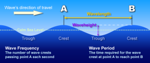
Since tsunamis are a type of wave, let’s first explain the anatomy of a wave or series of waves. The highest part of the wave is called the crest. The lowest part is called the trough. Wave height is the overall vertical change in height between crest and trough. The distance between two successive crests (or troughs) is the length of the wave, or wavelength.
While the passage of each wave is associated with an up and down motion, the water is actually moving in a circular motion. It is this orbital motion of the water that causes an object to bob up and down, forward and backward, as waves pass under it.
However, this motion is not exactly circular but trochoidal (imagine a curved line formed by tracing a point on a rolling wheel. In other words, while the motion is circular, there is still overall forward motion. Even over deep water, where a wave moves in an almost-closed circular path, there is still a tiny forward motion with the passage of each wave, particularly large waves.
Wind Waves
Factors involved in determining the height and movement of wind-driven waves are: wind velocity, fetch of the wind, and duration of the wind. An increase in any one of the three factors will create a larger wave.
Because wind waves have shorter wavelengths, their steepness tends to cause them to break at the shore in the typical curling wave. With their energy spent, wind waves then quickly recede.
Tsunami Waves
Tsunamis are a series of long waves generated by a large and sudden displacement of the ocean. Large earthquakes below or near the ocean floor are the most common cause, but landslides, volcanic activity, certain types of weather, and meteorites can also cause a tsunami. Tsunamis are sometimes referred to as “tidal waves”, but this is very misleading as they are not related to tides.
Tsunamis radiate outward in all directions from their source and can move across entire ocean basins. When they reach the coast, they can cause dangerous coastal flooding and powerful currents that can last for several hours or days.
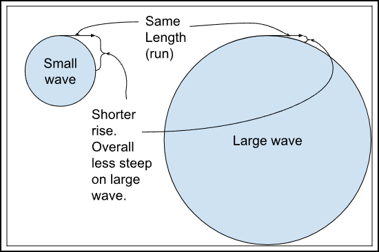
The longer the wavelength, the greater the volume of water involved. Though they appear smaller in height (distance between trough and crest) in the deep ocean than some wind waves, tsunamis can grow to much greater heights and cause much more destruction than wind waves at the coast.
The energy in a tsunami is not readily spent. They do not typically curl and break like wind waves. To break, a wave needs to be very steep. Because of their long wavelengths, tsunamis do not tend to reach the steepness required to break.
Large Waves have Less Steep Slope.
It is because of these long wavelengths, the volume of water they carry, and the amount energy they transmit that tsunamis are so dangerous. Instead of breaking on the shore and quickly receding, a tsunami is more likely to rush onto land like a fast-rising flood and inundate low-lying areas before returning back to the ocean.
In deep water, as the depth increases, the wave motion changes fairly rapidly. The curved trochoidal shape at the surface flattens further down, and the total motion decreases. This flattening and decreasing continues with increasing water depth until all that remains is a small back and forth movement. Eventually, when that motion decreases to one-half of the wave’s total length, it will cease as well. In shallow water, the same flattening of the circular wave motion occurs, but there is no decrease in the forward/backward motion.
As a deep-water wave reaches shore, it begins to interact with the bottom. When the depth of the water is one-half of the wave’s length, drag (friction) from the bottom will cause the waves to slow down, and grow taller. While kinetic energy (velocity) was the dominant form in the deep ocean, potential energy (high waves) is the dominant form near shore. These wave peaks will continue to grow until they become unstable and, moving faster than the water below, break forward.
The speed at which a wave moves through the water is dependent on the wave’s length and the depth of the water. Generally, the longer the wavelength, the faster it moves. Tsunamis can have extremely long wavelengths (60 miles/100 km or more) and thus move around 550 mph (900 km/h).
TEMPORAL COMPONENT
Although they occur relatively infrequently and most are small and nondestructive, they can be a serious threat to life and property. Since 1850, tsunamis have claimed hundreds of thousands of lives and caused hundreds of billions of dollars in damage around the world. A tsunami can strike any ocean coast at any time. There is no season for tsunamis. This is quite evident when we look at some records of past tsunamis.
HISTORY of TSUNAMIS
We live on a geologically active planet where earthquakes and tsunamis have always occurred, within all oceans and impacting all continents. An early record is from the explosive eruption of the volcanic island of Santorini (Thera) in the Aegean Sea around 1610 BC. It generated a tsunami that swept the shores of nearby islands and contributed to the end of the Minoan culture on the nearby island of Crete.
Understanding when and where tsunamis have happened in the past and the extent of their impacts supports improved planning and preparedness for future tsunamis.
On average, two tsunamis cause damage near their source each year. Tsunamis that cause damage or deaths on distant shores (more than 1,000 kilometers – 620 miles – away) occur about twice per decade. Two of the most noteworthy tsunamis happened in this century and demonstrate the devastating impacts:
Deadliest Tsunami in History
On December 26, 2004, an extremely powerful earthquake occurred off the coast of the Indonesian island of Sumatra in the Indian Ocean. This magnitude 9.1 earthquake, the third largest in the world since 1900, generated a tsunami that reached as high as 167 feet (51 meters) and caused flooding up to three miles (five kilometers) inland.
Tsunami damage in Banda Aceh, Indonesia, from the 2004 tsunami.
The tsunami, not the earthquake, was responsible for the majority of the impacts, which were observed in 17 countries in Southeastern and Southern Asia and Eastern and Southern Africa. Impacts included approximately 230,000 deaths, the displacement of 1.7 million people, and roughly $13 billion (2017 dollars) in economic losses.
The extent of the losses was partly because of the lack of an official tsunami warning system in the Indian Ocean at the time and limited knowledge about tsunamis.
Modeled wave height (colors) and travel times (lines) of the 2004 Indian Ocean tsunami.Download Image
The Global Historical Tsunami Database contains information about over 1,200 confirmed tsunamis between 1610 BC and AD 2017. Of these, at least 250 were deadly. Here are the ten deadliest tsunamis on record.
*M=magnitude. Earthquake intensity estimated prior to 1896.
#May include earthquake deaths.
CAUSES
Earthquakes
Where the surfaces of tectonic plates catch and lock along their boundary, stress builds up as the rest of the plates continue to move. When the stress becomes too great, the plates suddenly slip past one another, releasing tremendous amounts of energy, which causes the earth to shake and crack.
Tsunamis can be generated by earthquakes on all faults, but most tsunamis, and the largest, result from earthquakes on reverse faults. These tsunami-generating earthquakes originate mainly in subduction zones, where tectonic plates collide and one is forced under the other.
Stuck to the subducting plate, the overriding plate gets squeezed. Its leading edge is dragged down, while an area behind bulges upward. This movement goes on for decades or centuries, slowly building up stress. Download Image
An earthquake along a subduction zone happens when the leading edge of the overriding plate breaks free and springs seaward, raising the sea floor and the water above it. This uplift starts a tsunami. Meanwhile, the bulge (dashed line) behind the leading edge collapses, thinning the plate and lowering coastal areas. Download Image
If big enough and close enough to the ocean floor, the energy from such an earthquake can cause the ocean floor to suddenly rise (uplift) or fall (subside). This sudden vertical displacement of the ocean floor is what typically sets a tsunami in motion.
As the ocean floor rises or falls, so too does the water above it. As the water moves up and down to regain its balance, a tsunami is born.
Not all earthquakes cause tsunamis. Key earthquake characteristics that contribute to tsunami generation are location, magnitude (size), and depth.
Most tsunamis are generated by earthquakes with magnitudes over 7.0 that occur under or very near the ocean and less than 100 kilometers (62 miles) below Earth’s surface (earthquakes deeper than this are unlikely to displace the ocean floor).
Generally, an earthquake must exceed magnitude 8.0 to generate a dangerous distant tsunami. The amount of movement of the ocean floor, the size of the area over which an earthquake occurs, and the depth of the water above the earthquake are also important factors in the size of a resulting tsunami.
Most of the tsunamis (89%) in the Global Historical Tsunami Database were generated by large earthquakes or landslides caused by earthquakes.
In addition to the previously highlighted tsunamis (2004 and 2011), other examples of earthquake-generated tsunamis include:
November 1, 1755, Lisbon, Portugal – A magnitude 8.5 (estimated) earthquake in the Atlantic Ocean generated a tsunami that affected the coasts of Portugal, Spain, North Africa, and the Caribbean. The earthquake and tsunami killed an estimated 50,000 people and caused widespread destruction.
January 26, 1700, Cascadia Subduction Zone – A magnitude 9.0 (estimated) earthquake generated a tsunami that inundated the coasts of Cascadia (a region that includes northern California, Oregon, Washington, and southern British Columbia) as well as coastal villages across the Pacific Ocean in Japan. Today, the Cascadia subduction zone is considered one of the largest U.S. tsunami threats.
LANDSLIDES
Relating to tsunami generation, “landslide” is a general term that describes a number of types of ground movement, including rock falls, slope failures, debris flows, and slumps. While icefalls/avalanches and glacial calving (the breaking off of large pieces of ice from a glacier) are not really landslides, they act the same and are considered in this discussion of landslides.
Tsunamis can be generated when a landslide displaces the water from above (subaerial) or below (submarine). Tsunami generation depends on the amount of landslide material that displaces the water, the speed it is moving, and the depth it moves to.
Near their source, landslide-generated tsunamis may be larger than tsunamis generated by earthquakes and can affect nearby coasts within minutes with little to no warning. These tsunamis usually lose energy quickly and rarely affect distant coasts.
In November 1929, a magnitude 7.3 earthquake in the Atlantic Ocean triggered a submarine landslide that generated a tsunami. Waves up to 43 feet (13 meters) high were responsible for 28 deaths and $14 million (2017 dollars) in damage along the coast of Newfoundland, Canada. Source: Natural Resources Canada; Harris M. Mosdell, from the collection of W.M. Chisholm Download Image
While a number of forces can cause unstable slopes to suddenly fail, most landslides that generate tsunamis are caused by earthquakes. Even earthquakes that are not large enough to directly generate a tsunami may be large enough to cause a landslide that in turn can generate a tsunami.
A landslide-generated tsunami may occur independently or along with a tsunami directly generated by an earthquake, which can complicate the warning process and increase the losses.
Examples of landslide-generated tsunamis include:
July 10, 1958 Southeast Alaska – A magnitude 7.8 earthquake triggered a number of submarine landslides, rock falls, and ice falls that generated tsunamis that killed five people. A rock fall into Lituya Bay sent water surging over the opposite shore, clearing trees around the bay up to a maximum height of 1,720 feet (525 meters). It is considered the highest tsunami ever recorded.
On October 11, 1918 Puerto Rico – A magnitude 7.3 earthquake caused a submarine landslide that generated a tsunami. Waves up to 20 feet (6 meters) high struck the western and northern coasts of Puerto Rico. Damage from the earthquake and tsunami approximated $62 million (2017 dollars), and at least 140 lives were lost.
VOLCANOES
Tsunamis generated by volcanoes, both above and below water, are infrequent. Additionally, a volcano must be near the coast or not far below the sea surface to generate a significant tsunami. Like landslide-generated tsunamis, tsunamis generated by volcanic activity usually lose energy quickly and rarely affect distant coasts.
The Augustine Volcano in Alaska (2006). In 1883, a debris flow from the collapse of the north face of the Augustine Volcano’s peak caused a local tsunami. Damage to homes and fishing boats was reported. Source: U.S. Geological Survey, Game McGimsey Download Image
Several types of volcanic activity can displace enough water to generate destructive tsunamis, including:
Pyroclastic flows (flowing mixtures of rock fragments, gas, and ash)
Submarine explosions relatively near the ocean surface
Caldera formation (volcanic collapse)
Landslides (e.g., flank collapse, debris flows)
Lateral blasts (sideways eruptions)
Examples of volcano-generated tsunamis include:
August 27, 1883 Indonesia – The volcano Krakatau (Krakatoa) exploded and collapsed, generating one of the largest and most destructive tsunamis ever recorded. Waves reaching 135 feet (41 meters) high destroyed coastal towns and villages along the coasts of Java and Sumatra and killed more than 34,000 people.
May 21, 1792 Kyushu Island, Japan – At the end of the four-month eruption of the Unzen volcano, a flank collapse generated a tsunami with waves reaching 180 feet (55 meters) high that caused destruction around the Ariake Sea and more than 14,000 deaths.
WEATHER
Air pressure disturbances often associated with fast-moving weather systems, like squall lines, can also generate tsunamis. These “meteotsunamis” are similar to tsunamis generated by earthquakes, but their development depends on the intensity, direction, and speed of the air pressure disturbance as it travels over a body of water body that is deep enough to enhances wave magnification.
Most meteotsunamis are too small to notice, but large meteotsunamis can bring dangerous waves, flooding, and strong currents that can cause damage, injuries, and deaths (but not as extreme as the impacts caused by the recent earthquake-generated tsunamis in Japan and the Indian Ocean).
Meteotsunamis are regional, meaning they do not affect entire ocean basins. Certain parts of the world are prone to meteotsunamis due to a combination of factors, including local weather patterns, the depth and shape of the ocean floor near the coast (bathymetry), and coastal elevation and features (topography).
The leading edge of the squall line that generated a meteotsunami on the East Coast of the United States in June 2013. Download Image
June 13, 2013, Northeastern United States – Tsunami-like waves crashed upon the New Jersey and southern Massachusetts coasts despite clear skies and calm weather. In Barnegat Inlet, New Jersey, three people were injured when a six-foot (1.8-meter) wave swept them off a jetty and into the water. Scientists determined that the waves had been generated by a derecho (a high-speed windstorm associated with a strong band of thunderstorms) that had passed through the area hours earlier.
June 21, 1978, Vela Luka, Croatia – Without warning and during relatively nice weather, flooding waves inundated the port town of Vela Luka. Scientists identified the likely source as an air pressure disturbance the morning of the flooding. The strongest meteotsunami on record, this event featured 19.5-foot (6 meter) waves, lasted several hours, and caused millions of dollars in damage.
MOVEMENT: PROPAGATION
Once generated, tsunamis radiate outward in all directions from their source. Unlike wind waves that affect just the surface of the ocean, tsunamis propagate (move) through the entire depth of the ocean, from the surface to the floor. Large tsunamis can even move across entire oceans.
Tsunamis move at great speeds and have tremendous energy; the speed depends on the depth of the water it is traveling through. The deeper the water, the faster they move.
In the deep ocean, tsunamis can move as fast as a jet plane, over 500 mph (800 km/h), and can cross entire oceans in less than a day.
The distance between waves is the wavelength. Because of a tsunami’s long wavelengths, which can be hundreds of miles, a tsunami is barely noticeable in the deep ocean and rarely more than three feet (one meter) high.
Mariners at sea will not normally notice a tsunami as it passes beneath their hulls.
As a tsunami enters shallow water near land, it slows down, wavelengths decrease, waves grow in height, and currents intensify. At the shore, most tsunamis slow to the speed of a car, approximately 20 to 30 mph (30 to 50 km/h).
The amount of time it takes a tsunami to reach a coast depends on the location of the source of the tsunami relative to where it may strike land. Therefore, tsunamis are often referred to as local or distant.
The source of a local tsunami is close to a coast and it may arrive at nearby coasts in less than one hour, sometimes in just minutes.
Local tsunamis, also called local-source tsunamis and near-field tsunamis, pose the greatest threat because tsunamis are most damaging near their source, and there is little time to issue official warnings and evacuate. Additionally, official tsunami warning may not come quickly or at all if the source is not an earthquake or if the warning infrastructure is damaged.
The source of a distant tsunami is far away from a coast, sometimes on the other side of the ocean. This means there is more time to issue and respond to warnings (usually at least three hours).
For example, a tsunami generated off Russia will reach the Pacific Northwest Coast of the United States in 7-8 hours, and a tsunami generated off Chile will reach Southern California in about 13 hours. However, distant tsunamis can still have significant impacts on coastal communities.
Distant tsunamis are also called distant-source tsunamis, far-field tsunamis, and tele-tsunamis.
A tsunami can be both a local and a distant tsunami. For example, if an earthquake off the coast of Alaska causes a tsunami that affects both Alaska and Hawaii, it is a local tsunami for Alaska, but a distant tsunami for Hawaii.
Tsunami inundating Yamada, Japan, in 2011. Source: Earthquake Memorial Museum; Yamada, Japan
Not all tsunamis act the same, and each individual one may affect coasts differently due to local bathymetry and topography.
Reefs, bays, entrances to rivers, undersea features, and the slope of the shore can all influence the size, appearance, and impact of tsunamis when they strike the coast. A small nondestructive tsunami in one place may be very large and violent a few miles away.
A tsunami arrives at a coast as a series of successive crests (highest parts of the wave) and troughs (lowest parts of the wave). It may look like a fast-rising flood or a wall of water and will not look or act like a normal wind wave. Tsunamis rarely become great towering breaking waves.
Sometimes a tsunami arrives trough first, and, before the water rushes on land, it suddenly recedes, showing the ocean floor, reefs, and fish like a very low tide.
The tsunami arrived trough first in Phuket, Thailand, on December 26, 2004. Not recognizing the danger, many people ventured out to explore the newly exposed ocean bottom. In the distance, the frothy wavefront marks the rising crest of the first wave. Download Image
Tsunamis can travel up rivers and streams that lead to the ocean and wrap around headlands, islands, and sand spits. A tsunami’s long wavelength provides more momentum for inundation (flooding), so tsunamis often travel much farther inland than normal waves and are more destructive. A large tsunami can flood low-lying coastal areas more than a mile inland.
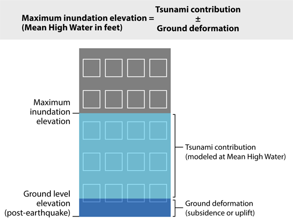
The maximum height above sea level a tsunami reaches on shore is called the runup. Most runups are less than 10 feet high, but in extreme cases, can exceed 100 feet when a tsunami strikes near its source.
The first wave to reach the shore may not be the last, the largest, or the most damaging. Large tsunamis may continue for days in some locations, reaching their peak often a couple of hours after arrival and gradually tapering off after that.
The time between tsunami crests is unpredictable and varied, typically ranging from approximately five minutes to two hours. Dangerous tsunami currents can last for days.
DANGERS
Even though tsunamis do not occur very often and most are small and cause little if any damage, they are a major threat to coastal communities. Tsunamis typically cause the most severe damage and casualties very near their source.
Damage in Crescent City, California, from the 2011 Japan tsunami, about 10 hours after the initial earthquake.
Tsunamis with runups over one meter (3.28 feet) are particularly dangerous to people and property, but smaller tsunamis can also be dangerous. Strong currents can injure and drown swimmers and damage and destroy boats and infrastructure in harbors.
Trash and debris cover the streets near homes in Banda Aceh, Indonesia, following the 2004 tsunami. Source: U.S. Department of Defense, Michael L. Bak
A tsunami’s height and impacts at a specific coastal location are influenced by the local bathymetry and topography and the direction from which the tsunami arrives. Low-lying areas such as beaches, bays, lagoons, harbors, river mouths, and areas along rivers and streams leading to the ocean are the most vulnerable.
Fast Facts:
Tsunamis can easily knock people off their feet and float vehicles:
6 inches of fast moving water can carry away and adult
12 inches of fast moving water can carry away a small car
18-24 inches of fast moving water can carry away most large SUVs, cans, and trucks.
Large tsunamis strike with tremendous force and are a significant threat to human health, coastal property and infrastructure, coastal resources, and coastal, regional, and even national economies.
Most tsunami damage and destruction is caused by flooding, wave impacts, erosion, strong currents, and floating debris (e.g., trees, structures, vehicles, and other things that can act like battering rams). The water can be just as dangerous, if not more so, as it returns to the sea, taking debris and people with it.
The debris in the water is particularly dangerous as evidenced by bruises on the bodies of many victims of the 2004 Indian Ocean tsunami.
In addition to loss of life and mass injuries, other potential impacts include damage to and destruction of homes and businesses, ports and harbors, cultural resources, utilities, and critical infrastructure and facilities. There may be loss of access to basic services such as power, sewer, and water. Communications, transportation (ground, air, and marine), and health and public safety services may be disrupted.
Impacts from a large local tsunami will likely be in addition to impacts from a preceding earthquake, and impacts from both may trigger secondary hazards, which could be more devastating than the direct destruction.
Earthquakes and tsunamis can cause fires, transportation accidents, and hazardous material releases into the environment, contaminating water supplies and threatening public health. These impacts can further complicate evacuation, response, and recovery.
Homes on India’s Nicobar Islands permanently submerged due to subsidence from the 2004 Indian Ocean earthquake. Source: Integrated Coastal and Marine Area Management, Chennai; Department of Defense, India
Earthquakes and tsunamis can also change the land, both above and below the water. In some places it may rise, in others it may fall. If the coast subsides (falls), flooding may be extended to unexpected areas and tsunami barriers may fail or be overtopped. Associated landslides and other sediment shifts and depositions can make waterways unnavigable.
Other potential consequences include permanent changes to beaches and other coastal features, loss of or changes to wildlife habitat, and changes to quality and availability of fresh water. Inundation by salt water, short or long term, can make agricultural land useless.
The force of the water, pollutants and toxic substances, sediment, marine debris, and invasive species can also harm agricultural land and natural resources on shore and off. Changes to these resources can affect the services they provide (e.g., biological, ecological, protective, and recreational).
Most Expensive Natural Disaster in History
On March 11, 2011, a magnitude 9.1 earthquake off the east coast of Japan generated a tsunami that caused tremendous devastation locally and was observed throughout the Pacific. The earthquake was the largest ever recorded in Japan. The tsunami reached as high as 127 feet (39 meters) and traveled up to five miles (eight kilometers) inland.
In Japan, the earthquake and tsunami caused more than 18,000 deaths and approximately $243 billion (2017 dollars) in damage. Most of the deaths and damage in Japan were due to the tsunami, which also displaced more than 500,000 people and resulted in a nuclear power plant accident.
Outside Japan, there was very little loss of life. Timely warnings and a large distance from the tsunami’s source gave more time for evacuations in coastal communities. However, there was still one death in Papua, Indonesia, and one death in California. The tsunami also caused approximately $94 million in damage in California and Hawaii and $7 million (2017 dollars) in losses to the fishing industry in Tongoy, Chile.
SPATIAL: Locations
Tsunamis can be generated in all of the world’s oceans, inland seas, and in any large body of water. They have caused damage and deaths in coastal areas all around the world and can strike any coast.
However, certain areas are particularly prone to tsunamis and the devastation they can bring. This is due to their location near local tsunami sources, exposure to distant tsunami sources, and local bathymetry and topography.
78% Pacific Ocean (around the geologically active “Ring of Fire”)
9% Atlantic Ocean and Caribbean Sea
6% Mediterranean Sea
5% Indian Ocean
1% Other Seas
The highest percentage of these tsunamis was generated off Japan (20%), followed by Russia (8%) and Indonesia (8%). While most tsunamis are small and nondestructive or only affect coasts near their source, some tsunamis can cause damage and deaths on distant shores. The most significant distant tsunamis since 1900 originated off Alaska, Chile, Japan, Indonesia, Pakistan, and Russia.
This is the most volcanically and seismically active zone in the world. It extends from Chile, northward along the South American coast through Central America, Mexico, the West Coast of the United States, and the southern part of Alaska, through the Aleutian Islands to Japan, the Philippine Islands, New Guinea, the island groups of the Southwest Pacific, and to New Zealand.
According to the U.S. Geological Survey, 90% of all earthquakes and 81% of the largest earthquakes happen along this “ring,” where the Pacific plate meets its surrounding plates.
An assessment of the tsunami hazard in the United States shows that while a tsunami can strike any U.S. coast, the hazard level varies. The hazard levels shown below are based largely on the historical record (through 2014), geological evidence, and location relative to tsunami sources, all of which provide clues to what might happen in the future.
Note: Historical records are brief and incomplete. Events may have been unreported or underreported or may have happened in unpopulated areas and gone undetected.
While a distant tsunami could strike any U.S. coast, the hazard is greatest for those near subduction zones, where large earthquakes and associated landslides can produce damaging waves that threaten nearby and distant coasts, like those around the Pacific and Caribbean.
The U.S. Atlantic and Gulf Coasts are not near subduction zones, and earthquakes off and along these coasts are not as large or as frequent as in other regions. The most likely tsunami sources for these coasts are submarine landslides and weather (which can generate meteotsunamis).
Runup is the maximum elevation of the tsunami flooding on shore. Tsunamis with runups over one meter (~3 feet) are particularly dangerous to people and property, but smaller tsunamis also pose threats.
A tsunami warning center is a vital part of a tsunami warning system. They have been established around the world with the primary goal of saving lives.
Most were created following large tsunamis that raised concern about the hazard, both on affected shores and beyond. A number of new warning centers became operational following the 2004 Indian Ocean tsunami.
In the United States, tsunami warning centers are part of a larger tsunami warning system that aims to minimize the impacts of tsunamis. Operated by the National Oceanic and Atmospheric Administration (NOAA), two tsunami warning centers are staffed 24 hours a day, 7 days a week. These centers monitor for tsunamis and the earthquakes that cause them, forecast tsunami impacts, and prepare and issue tsunami messages.
The Pacific Tsunami Warning Center (PTWC) in Hawaii was established following a 1946 tsunami that struck Hawaii, killing more than 150 people and causing over $300 million in damage (2017 dollars). The PTWC provides tsunami messages for the Hawaiian Islands, the U.S. Pacific and Caribbean territories, and the British Virgin Islands.It also provides forecast information to international partners in the Pacific and Caribbean and adjacent regions to help them understand the threat to their coasts so they can decide whether or not to issue alerts.
The National Tsunami Warning Center (NTWC) in Alaska was established after the largest recorded earthquake in U.S. history generated a number of destructive tsunamis in 1964. These tsunamis killed 124 people in Alaska, Oregon, and California and caused approximately $1 billion (2017 dollars) in damage.The NTWC provides tsunami messages for the continental United States, Alaska, and Canada.
Detecting Tsunamis and Issuing Messages
Like the earthquakes that generate most tsunamis, scientists cannot predict when and where the next tsunami will strike. But based on their knowledge of earthquakes and past tsunamis, scientists at the tsunami warning centers know which earthquakes are likely to generate tsunamis and can issue tsunami messages when they think a tsunami is possible.
To provide timely, reliable, and accurate tsunami warnings and forecasts, warning center scientists must be able to quickly detect and analyze earthquakes and observe and measure tsunamis.
To do this, they depend on information about earthquakes and tsunamis collected from seismic and water-level networks from around the world.
“Seismic” means relating to earthquakes. Seismic networks consist of seismic stations that detect, measure, and record earthquakes (and other types of ground motion) and transmit information to the warning centers in real time through satellites and other systems.
Seismic waves travel about 100 times faster than tsunamis, so information about an earthquake is available before information about any tsunami it may have generated.
Since a tsunami can strike nearby coasts within minutes, warning center scientists use an earthquake’s preliminary seismic information (magnitude, location, and depth) to decide if an earthquake could have generated a tsunami and if they should issue an initial tsunami message.
For U.S. and Canadian coasts, warning center scientists are typically able to issue initial messages within five minutes of an earthquake. These messages provide alert levels (warning, advisory, watch, information statement), preliminary information about the earthquake, and an evaluation of the threat.
If a tsunami is suspected, messages may also include wave arrival times, recommended actions, and potential impacts. These messages are sent through multiple channels to emergency managers, other officials, news media, and the public.
Messages are updated regularly throughout an event as information becomes available.
If the warning center scientists decide a tsunami is possible, they monitor information from water-level networks to determine the existence and size of a tsunami and to verify, adjust, or cancel messages.
NOAA established and maintains two essential water-level networks that send information about water-level height to the warning centers by satellite, the Internet, and private circuits:
Deep-ocean Assessment and Reporting of Tsunami (DART) systems: A network of DART systems supports the early detection, measurement, and real-time reporting of tsunamis in the deep ocean. DART systems measure passing tsunamis by sensing pressure changes at the bottom of the ocean (as water depth increases, pressure increases).The U.S. network, part of a larger international network, consists of 39 DART systems located throughout the Pacific and Atlantic Oceans, the Gulf of Mexico, and the Caribbean Sea.Take it to the MAX! Deep-ocean Assessment and Reporting of Tsunami
Coastal water-level stations: An extensive network of water-level stations near the coast, generally on piers in harbors, measures the height of the ocean at specific locations. Their primary purpose is to monitor tides for navigation purposes, but they are also used to confirm tsunami arrival time and height.
The time it takes to detect a tsunami depends on the distance between its source and the nearest DART system or coastal water-level station. Normal time frames range from five minutes to two hours.
Forecasting Tsunamis
If a tsunami is detected, the warning center scientists run tsunami forecast models using real-time information from the seismic and water-level networks, preset scenarios, bathymetry, and topography to show how the tsunami will move across the ocean and to estimate impacts at specific coastal locations. Impact information includes wave height and arrival times, location and extent of coastal flooding, and how long the tsunami will last.
The resulting forecasts, combined with historical tsunami information and additional seismic analysis, help the warning center scientists make decisions about adjusting and cancelling messages.
These forecasts are included in updated tsunami messages and provide local officials with information that can guide decisions about evacuation, including pedestrian and traffic routes, and beach and road closures.
COMMUNITY PREPAREDNESS
Of all Earth’s natural hazards, tsunamis are among the most infrequent. Major tsunamis do not happen often, but when they do, they can have a significant impact on life and property. Even small tsunamis, which are more frequent, can cause loss of life, injuries, and considerable damage.
But there are things communities can do before, during, and after a tsunami that can save lives and minimize losses.
Tsunami impacts can vary greatly from one community to the next depending on their local bathymetry and topography. So to prepare for a tsunami, coastal communities should conduct hazard assessments to understand how tsunamis of different sizes and sources (location and type) might affect them.
A hazard assessment includes using computer models and information from past tsunamis to identify and map the areas likely to be flooded during a tsunami and by how much.
Communities can use the resulting tsunami hazard zone maps to determine where people and other important community assets (e.g., buildings, facilities, bridges, schools, hospitals) are at risk so they can decide where to focus preparedness, response, and mitigation efforts.
Communities that understand their tsunami risk are better prepared to protect the public in the event of a tsunami. Protective measures include:
Planning and practicing for response to tsunamis;
Warning the public;
Establishing, marking, and publicizing evacuation routes; and
Educating the public (residents and visitors) about tsunamis and tsunami safety before a tsunami strikes.
The first tsunami vertical structure in the United States: Ocosta Elementary School, Westport, Washington. The building is designed to withstand an earthquake and has a flat roof over the gym to accommodate up to 1,000 students and community members from a resulting tsunami. Source: Pete Eckert, Eckert & Eckert Photography
The state of Washington has adopted building codes in tsunami design zones for some structures to withstand some amount of inundation.
Inundation Level and Structures (https://www.dnr.wa.gov/wa-tdz#2021-tsunami-design-zone)
Other ways to prepare for and mitigate the potential impacts of a tsunami emphasize thoughtful land-use planning and building design in tsunami hazard zones and include the following:
Improving evacuation routes
Building tsunami evacuation structures
Limiting new development in tsunami hazard zones
Designing, siting, and building structures to minimize tsunami damage
Adopting building codes that address tsunamis
Protecting and strengthening existing structures and infrastructure that, if damaged, would negatively affect response and recovery
Moving important community assets and vulnerable populations out of tsunami hazard zones
Planning for post-tsunami recovery
To be recognized as TsunamiReady and display this sign, a community must have implemented the activities established in the TsunamiReady Guidelines. Download Image
In the United States, much of the tsunami preparedness and mitigation work is conducted through two programs:
The National Tsunami Hazard Mitigation Program is a federal/state partnership led by NOAA that also includes the Federal Emergency Management Agency, the U.S. Geological Survey, and 28 U.S. states and territories. Through collaboration, coordination, and support to partner states and territories, the program focuses on three key functions: hazard assessment, warning guidance, and mitigation.
The NWS TsunamiReady® program is a voluntary community recognition program that helps communities minimize the risk posed by tsunamis through better risk assessment, planning, education, and warning communications. The Intergovernmental Oceanographic Commission of the United Nations Educational, Scientific, and Cultural Organization modeled their International Tsunami Ready programoffsite link on the NWS program.
INDIVIDUAL PREPAREDNESS
Tsunami warning centers and coastal communities play critical roles in protecting the public from tsunamis, but ultimately it is up to YOU to know how to protect yourself and your loved ones. If you live, work, or play on the coast, you should prepare for tsunamis.
Many of the things you need to do to prepare for a tsunami are the same as you would do to prepare for other hazards that may affect your community. It is not hard, and it is not expensive. Here are some things you can do now:
Know Your Risk
Find out if your home, school, workplace, other places you visit often, or vacation destination are in a tsunami hazard zone. Has your community had tsunamis in the past? If so, were they local or distant?”
Remember: Local tsunamis are a greater threat since tsunamis are most damaging near their source, and there is little time (sometimes just minutes) to get to a safe place.
Understand Tsunami Warnings
Understand the two types of tsunami warnings, official and natural, and how to respond to them. They are equally important, and you may not get both. Respond immediately to whichever you receive first.
Most of coastal Washington has sirens installed in tsunami zones. They are officially called AHAB (All Hazards Alert Broadcast). In the event of a tsunami, the siren will sound, followed by voice instructions. A blue light is included for hearing impaired.
It may also come through outdoor sirens, local officials, text message alerts, and telephone notifications. Evacuation is recommended.
Move to a safe place on high ground or inland (away from the water). Follow instructions from local officials. In the case of a local tsunami, there may not be time to wait for an official tsunami warning.
A natural tsunami warning may the first, best, or only warning that a tsunami is on its way. Natural tsunami warnings include strong or long earthquakes, a loud roar (like a train or an airplane) from the ocean, and unusual ocean behavior.
The ocean could look like a fast-rising flood or a wall of water. Or, it could drain away suddenly, showing the ocean floor, reefs, and fish like a very low, low tide. Any of these warnings, even just one, means a tsunami could arrive within minutes.
Protect yourself from the earthquake, if necessary, and move quickly to a safe place on high ground or inland (away from the water). Do not wait for an official warning.
Practice All-Hazards Preparedness
Practice All-Hazards Preparedness: Have an emergency plan that includes multiple ways to receive tsunami messages and plans for family communication and put together easily accessible portable disaster supplies kits.
Plan for Evacuation
Learn about existing evacuation routes or map out routes from home, work, and other places you visit often to safe places on high ground or inland (away from the water). Plan to evacuate on foot if you can; roads may be impassable due to damage, closures, or traffic jams.
It is also important to know what to do during and after a tsunami. This includes staying informed and staying safe. After a tsunami, local officials will assess the damage and decide when it is safe to return. Even though the danger of the tsunami has passed, other dangers may remain (debris, fires, unstable structures, etc.). If there is a lot of damage, it may be days before it is safe to return to affected areas.
Plan for Safe Boating
If you are on a boat and get a tsunami warning, your response will depend largely on where you are. In general, in the United States, it is recommended that:
If you are in a harbor and get a warning, you should leave your boat and move quickly to a safe place on land (high ground or inland, away from the water).
If you are at sea and get a tsunami warning, you should move to a safe depth and stay away from harbors under warning until officials tell you the danger has passed. Safe depths for boaters vary by region, but the minimum safe depth in the United States is 30 fathoms (180 feet). Your harbor master, port captain, the U.S. Coast Guard, and local and state emergency management offices are the best sources for safe depth and other tsunami safety information and regulations for boaters in your area.
If you are a boat owner or captain, make sure you have a way to receive tsunami warnings when you are on the water and keep a disaster supplies kit on the boat. If you are at sea during a tsunami, you may not be able to return to the harbor you left. Be prepared to remain at sea for a day or more.


 and travel times (lines) of the 2004 Indian Ocean tsunami.")


")
")


. Source: Adapted from U.S. Geological Survey")


.")