8 Volcanoes
Introduction
- Much of the content of this chapter is copied from the Washington Dept of Natural Resources the USGS Volcano Hazards Program and the National Park Service.
Spatial Component of Volcanoes
Global

National (USA)

State and Region (Washington and Pacific Northwest)

Washington has five volcanoes that are listed as high or very high threat potential: Mount Baker, Glacier Peak, Mount Rainier, Mount St. Helens, and Mount Adams. These volcanoes are part of the Cascade Range, a 1,200-mile line of volcanoes from British Columbia to northern California.
Temporal Component of Volcanoes
Many volcanoes in Washington are active and have had recent eruptions. Volcanoes do not erupt at regular intervals, so it is difficult to know exactly when or where the next eruption will happen.

The Physical Component of Volcanoes
Many hazards come with living near volcanoes. Volcanic eruptions can send ash and volcanic debris into the air. Heat from the volcano can melt snow or ice and cause dangerous mudflows and debris flows called lahars. Molten rock called lava can erupt and flow downhill, destroying everything in its path.
Volcanoes are also beautiful mountains that many people visit each year for recreation. Volcanoes are the most visual result of plate tectonics and are one of the few places on Earth where molten rock can reach the surface.
Classifying Eruptions
As with all natural hazards, a few truly catastrophic events have killed far more people than the combination of the smaller eruptions.

Eruption Style and Vigor: the 3 V’s
Each eruption, even at the same mountain, can behave differently with different results. To clarify these differences, we look at the Viscosity, Volatility, and Volume of the eruption.
Viscosity is the resistance to flow. Molasses has a high viscosity while water has a comparatively low viscosity. Lave with a low viscosity will flow faster and it will flow farther before it cools and solidifies. Therefore the material will be spread out thinly over a large area. This is an effusive eruption. Most Hawaiian and Icelandic eruptions are in this category. Mt. St. Helens and Mt. Rainier will have more viscous material. The lava won’t flow far before cooling so those mountains have thick deposits from each eruption and steep slopes.
The viscosity also influences the volatility. Some eruptions only last a few minutes to hours and eject a lot of material in a short time. Those are explosive eruptions (Mt. St. Helens). Highly viscous material doesn’t allow gases to escape from the magma before reaching the land surface. The gasses escape during the eruption becoming a huge bubble burst! With low viscosity magma, the gasses come out of solution and leave the magma before the eruptions. The energy of the exploding bubbles is gone before the magma reaches the earth’s surface. That’s a low volatility eruption.
The volume of the eruption refers to amount of material moved, not how loud the eruption is! This is a useful measure because we can think of the energy required to move the mass of material that occupied that volume.
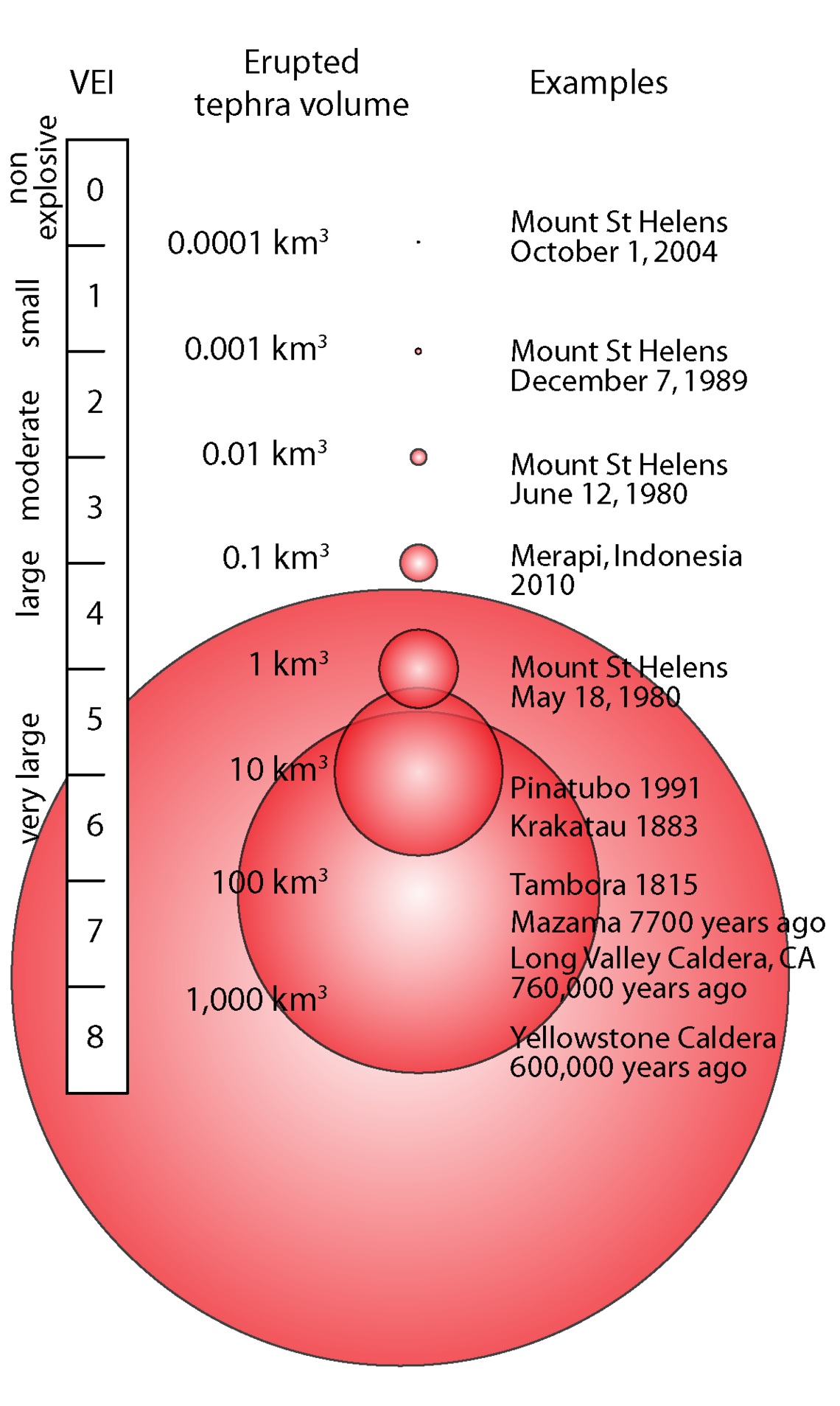
The Volcanic Explosivity Index is based on the volume of material ejected and the height the material went into the atmosphere. It’s used to compare the magnitude and intensity of eruptions. An effusive eruption, with flowing lava and minimal material ejected into the atmosphere, has a VEI of 0. Very large eruptions that demolish large mountains rank up to a VEI of 8. It is a logarithmic scale in terms of the volume of ejecta.
For comparison, the Oct. 1, 2004 eruption of Mt. St. Helens ejected 0.0001 km3 of material. A common dump truck for hauling soil and rock can carry about 10 m3 so that ‘small’ eruption is equivalent to about 10,000 dump truck loads.
Monitoring and Warning:
When a mountain has a known history of eruptions and we know it is a hazard, there are several characteristics that are monitored: Earthquakes, Land Deformation, Outgassing.
The first characteristic is earthquakes. As heat and magma move up into a volcano, they create earthquakes. Heat can make via conduction and rock material expands. The expansion is a movement that is detected by seismometers. Magma also moves through the volcano and displaces material. This figure shows a ring of seismometers (yellow triangles) around Mt. St. Helens, many earthquakes clustered at the crater, and most events are 11 km below the surface.


Many, if not also threatening volcanoes have a set of seismometers near them to specifically identify quakes in and near that volcano. In the section on earthquakes, we mentioned that there’s always some movement, some background noise in the seismic signals. Volcanologists will look for is a change in those background signals. They watch for quakes to move closer to the land surface, or become more frequent, or more powerful.
The second characteristic is land deformation. As the heat and the magma near the surface, the surface deforms. It usually rises as it being pushed up by the magma. The movement and elevation change is detected by satellite surveillance or land based surveying. This land deformation can destabilize material and lead to landslides.
When a fluid is under pressure, it’s able to hold more dissolved gasses. When pressure is decreased, some gasses may become super saturated, form bubbles in the fluid, and begin to move within the fluid. Eventually some gas molecules escape the magma entirely. As a gas, they move more easily through the mountain, especially and the mountain develops more cracks from land deformation. The chemistry, and quantity of gases at a volcano is also used to asses the threat of an eruption.
National Volcano Early Warning System
BELOW THIS MAY BE REPETITIVE. IT’s BEING HEAVILY EDITED BEFORE COMBINED WITH THE INFORMATION ABOVE
VOLCANOES ALONG CONVERGENT PLATE BOUNDARIES
Volcanoes are a vibrant manifestation of plate tectonics processes. Volcanoes are common along convergent and divergent plate boundaries, but are also found within lithospheric plates away from plate boundaries. Wherever mantle is able to melt, volcanoes may be the result.
Volcanoes erupt because mantle rock melts. The first stage in creating a volcano is when mantle rock begins to melt because of extremely high temperatures, lithospheric pressure lowers, or water is added. Along subducting plate boundaries, the crust heats up as it sinks into the mantle. Also, ocean water is mixed in with the sediments lying on top of the subducting plate. This water lowers the melting point of the mantle material, which increases melting. Volcanoes at convergent plate boundaries are found all along the Pacific Ocean basin, primarily at the edges of the Pacific, Cocos, and Nazca plates.
Large earthquakes are extremely common along convergent plate boundaries. Since the Pacific Ocean is rimmed by convergent and transform boundaries, about 80% of all earthquakes strike around the Pacific Ocean basin and is why the region is called the Ring of Fire. A description of the Pacific Ring of Fire along western North America is below:
- Subduction at the Middle American Trench creates volcanoes in Central America.
- The San Andreas Fault is a transform boundary.
- Subduction of the Juan de Fuca plate beneath the North American plate creates the Cascade volcanoes like Mount St. Helens, Mount Rainer, Mount Hood and more.
- Subduction of the Pacific plate beneath the North American plate in the north creates the long chain of the Aleutian Islands volcanoes near Alaska.
This incredible explosive eruption of Mount Vesuvius in Italy in A.D. 79 is an example of a composite volcano that forms as the result of a convergent plate boundary.
VOLCANOES ALONG DIVERGENT PLATE BOUNDARIES

Why does melting occur at divergent plate boundaries? Hot mantle rock rises where the plates are moving apart. This releases pressure on the mantle, which lowers its melting temperature allowing lava to erupt through long cracks or fissures. Scientists have captured incredible footage of “Deepest Ocean Eruption Ever Filmed” and other undersea volcanoes. Volcanoes erupt at mid-ocean ridges, such as the Mid-Atlantic ridge, where seafloor spreading creates new seafloor in the rift valleys. Where a hotspot is located along the ridge, such as at Iceland, volcanoes grow high enough to create islands. Eruptions are found at divergent plate boundaries as continents break apart such as the East African Rift between the African and Arabian plates and the Great Basin and Range in the western United States. But those volcanoes of the ladder are now extinct.
VOLCANIC HOTSPOTS
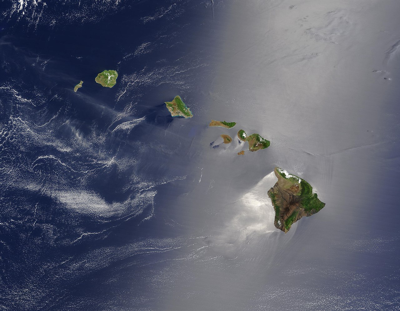
Although most volcanoes are found at convergent or divergent plate boundaries, intraplate volcanoes are found in the middle of a tectonic plate. The Hawaiian Islands are the exposed peaks of a great chain of volcanoes that lie on the Pacific plate. These islands are in the middle of the Pacific plate. The youngest island sits directly above a column of hot rock called a mantle plume. As the plume rises through the mantle, pressure is released and mantle melts to create a hotspot.
Earth is home to about 50 known hot spots. Most of these are in the oceans because they are better able to penetrate oceanic lithosphere to create volcanoes. The hotspots that are known beneath continents are extremely large, such as Yellowstone. The video on the right is of the hot spot beneath Hawaii, the origin of the voluminous lava produced by the shield volcano Kilauea. There are several key indicators to determine a hot spot from island arc volcanoes. At island arcs, the volcanoes are all about the same age. By contrast, at hotspots the volcanoes are youngest at one end of the chain and oldest at the other.

LOCATION AND MAGMA COMPOSITION
It should first be noted that magma is molten material inside the earth, whereas lava is molten material on the surface of the earth. The reason for the distinction is because lava can cool quickly from the air and solidify into rock rapidly, whereas magma may never reach the earth’s surface. Volcanoes do not always erupt in the same way. Each volcanic eruption is unique, differing in size, style, and composition of erupted material. One key to what makes the eruption unique is the chemical composition of the magma that feeds a volcano, which determines (1) the eruption style, (2) the type of volcanic cone that forms, and (3) the composition of rocks that are found at the volcano.
Different minerals within a rocks melt at different temperatures and the amount of partial melting and the composition of the original rock determine the composition of the magma. Magma collects in magma chambers in the crust at 160 kilometers (100 miles) beneath the surface of a volcano.
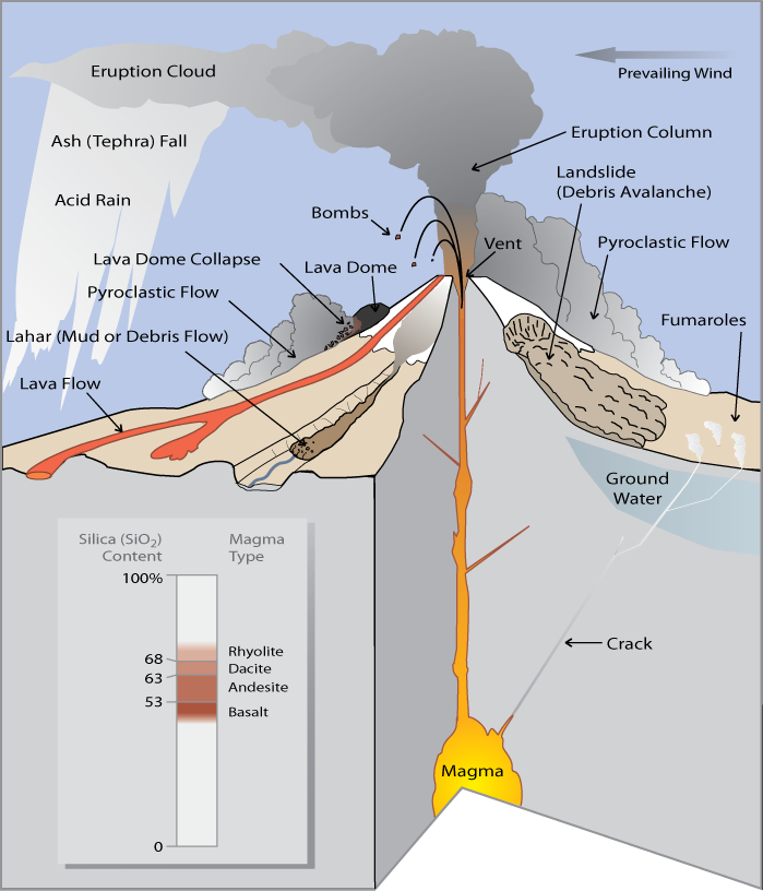
The words that describe composition of igneous rocks also describe magma composition. Mafic magmas are low in silica and contain more dark, magnesium and iron rich mafic minerals, such as olivine and pyroxene. Felsic magmas are higher in silica and contain lighter colored minerals such as quartz and orthoclase feldspar. The higher the amount of silica in the magma, the higher is its viscosity. Viscosity is a liquid’s resistance to flow.
Viscosity determines what the magma will do. Mafic magma is not viscous and will flow easily to the surface. Felsic magma is viscous and does not flow easily. Most felsic magma will stay deeper in the crust and will cool to form igneous intrusive rocks such as granite and granodiorite. If felsic magma rises into a magma chamber, it may be too viscous to move and so it gets stuck. Dissolved gases become trapped by thick magma and the magma chamber begins to build pressure.
EXPLOSIVE ERUPTIONS
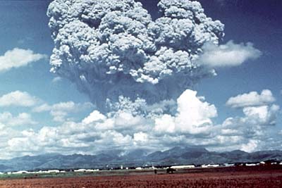
The type of magma in the chamber determines the type of volcanic eruption. A large explosive eruption creates even more devastation than the force of the atom bomb dropped on Nagasaki at the end of World War II in which more than 40,000 people died. A large explosive volcanic eruption is 10,000 times as powerful. Felsic magmas erupt explosively because of hot, gas-rich magma churning within its chamber. The pressure becomes so great that the magma eventually breaks the seal and explodes, just like when a cork is released from a bottle of champagne. Magma, rock, and ash burst upward in an enormous explosion creating volcanic ash called tephra. It should be noted that when looked under a microscope, the volcanic “ash” is actual microscopic shards of glass. That is why it is so dangerous to inhale the air following an eruption.
Scorching hot tephra, ash, and gas may speed down the volcano’s slopes at 700 km/h (450 mph) as a pyroclastic flow. Pyroclastic flows knock down everything in their path. The temperature inside a pyroclastic flow may be as high as 1,000°C (1,800° F).
Prior to the Mount St. Helens eruption in 1980, the Lassen Peak eruption on May 22, 1915, was the most recent Cascades eruption. A column of ash and gas shot 30,000 feet into the air. This triggered a high-speed pyroclastic flow, which melted snow and created a volcanic mudflow known as a lahar. Lassen Peak currently has geothermal activity and could erupt explosively again. Mt. Shasta, the other active volcano in California, erupts every 600 to 800 years. An eruption would most likely create a large pyroclastic flow, and probably a lahar. Of course, Mt. Shasta could explode and collapse like Mt. Mazama in Oregon.
Volcanic gases can form poisonous and invisible clouds in the atmosphere that could contribute to environmental problems such as acid rain and ozone destruction. Particles of dust and ash may stay in the atmosphere for years, disrupting weather patterns and blocking sunlight.
EFFUSIVE ERUPTIONS

Mafic magma creates gentler effusive eruptions. Although the pressure builds enough for the magma to erupt, it does not erupt with the same explosive force as felsic magma. People can usually be evacuated before an effusive eruption, so they are much less deadly. Magma pushes toward the surface through fissures and reaches the surface through volcanic vents. Click here to view a lava stream within the vent of a Hawaiian volcano using a thermal camera. Low-viscosity lava flows down mountainsides. Differences in composition and where the lavas erupt result in lava types like a ropy form pahoehoe and a chunky form called aa. Although effusive eruptions rarely kill anyone, they can be destructive. Even when people know that a lava flow is approaching, there is not much anyone can do to stop it from destroying a building, road, or infrastructure.

Volcanologists attempt to forecast volcanic eruptions, but this has proven to be nearly as difficult as predicting an earthquake. Many pieces of evidence can mean that a volcano is about to erupt, but the time and magnitude of the eruption are difficult to pin down. This evidence includes the history of previous volcanic activity, earthquakes, slope deformation, and gas emissions.
HISTORY OF VOLCANIC ACTIVITY

A volcano’s history, how long since its last eruption and the recurrence interval between its previous eruptions, is a good first step to predicting eruptions. If the volcano is considered active, it is currently erupting or shows signs of erupting soon. A dormant volcano means there is no current activity, but it has erupted recently. Finally, an extinct volcano means their is no activity and will probably not erupt again. Active and dormant volcanoes are heavily monitored, especially in populated areas.
EARTHQUAKES
Moving magma shakes the ground, so the number and size of earthquakes increases before an eruption. A volcano that is about to erupt may produce a sequence of earthquakes. Scientists use seismographs that record the length and strength of each earthquake to try to determine if an eruption is imminent.
Magma and gas can push the volcano’s slope upward. Most ground deformation is subtle and can only be detected by tiltmeters, which are instruments that measure the angle of the slope of a volcano. But ground swelling may sometimes create huge changes in the shape of a volcano. Mount St. Helens grew a bulge on its north side before its 1980 eruption. Ground swelling may also increase rockfalls and landslides.
GAS EMISSIONS
Gases may be able to escape a volcano before magma reaches the surface. Scientists measure gas emissions in vents on or around the volcano. Gases, such as sulfur dioxide (SO2), carbon dioxide (CO2), hydrochloric acid (HCl), and even water vapor can be measured at the site or, in some cases, from a distance using satellites. The amounts of gases and their ratios are calculated to help predict eruptions.
REMOTE MONITORING and DEFORMATION
Some gases can be monitored using satellite technology. Satellites also monitor temperature readings and deformation. As technology improves, scientists are better able to detect changes in a volcano accurately and safely.
Since volcanologists are usually uncertain about an eruption, officials may not know whether to require an evacuation. If people are evacuated and the eruption doesn’t happen, the people will be displeased and less likely to evacuate the next time there is a threat of an eruption. The costs of disrupting business are great. However, scientists continue to work to improve the accuracy of their predictions.

A volcano is a vent through which molten rock and gas escape from a magma chamber and they can differ in height, shape, and slope steepness. Some volcanoes are tall cones and others are just cracks in the ground. As you might expect, the shape of a volcano is related to the composition of its magma.
COMPOSITE (STRATO) VOLCANOES
Composite volcanoes are some of the most dangerous volcanoes on the planet. They tend to occur along oceanic-to-oceanic or oceanic-to-continental boundaries because of subduction zones. They tend to be made of felsic to intermediate rock and the viscosity of the lava means that eruptions tend to be explosive. The viscous lava cannot travel far down the sides of the volcano before it solidifies, which creates the steep slopes of a composite volcano. Viscosity also causes some eruptions to explode as ash and small rocks. The volcano is constructed layer by layer, as ash and lava solidify, one upon the other and are sometimes called stratovolcanoes or andesite volcanoes. The result is the classic cone shape of composite volcanoes. Examples of composite volcanoes include Mount St. Helens, Mount Rainer, Mount Shasta, Mount Hood, and Mount Pinatubo. Here’s a great time-lapse of Mount St. Helens from NASA’s Earth Observatory from 1979 to 2013.Sometimes composite volcanoes and other violent volcanoes can erupt so violently that they sometimes collapse in on themselves or actually blow themselves up to produce calderas. One of the most powerful volcanoes in the world – Yellowstone – is a massive caldera that has collapsed several times. Sometimes these calderas can fill up with water to produce beautiful lakes such as Mount Mazama (Crater Lake), in Oregon.
SHIELD VOLCANOES
Shield volcanoes get their name from their shape. Although shield volcanoes are not steep, they may be very large. In fact, Mauna Loa, Hawaii is the tallest mountain in the world. From sea level, Mount Everest is the tallest, but when you consider from the ocean floor to the top of the island, Mauna Loa wins. Shield volcanoes are common at spreading centers or intraplate hot spots.
The lava that creates shield volcanoes is fluid and flows easily and creates the shield shape. Shield volcanoes are built by many layers over time and the layers are usually of very similar composition. The low viscosity also means that shield eruptions are non-explosive. Eruptions tend to be mild in comparison to other volcanoes, but lava flows can destroy property and vegetation. The low viscosity magma can flow not only on the surface as lava, but also underground in lava tubes. The most well known shield volcano is Hawaii. There are two types of lava flows, pahoehoe which is a ropy type of lava that flows easily (low viscosity). The other type is called aa and is a blocky type of lava and has a higher viscosity and does not like to flow well.

CINDER CONES
Cinder cones are the most common type of volcano. A cinder cone has a cone shape, but is much smaller than a composite volcano. Cinder cones rarely reach 300 meters in height but they have steep sides. Cinder cones grow rapidly, usually from a single eruption cycle. Cinder cones are composed of small fragments of rock, such as pumice, piled on top of one another. The rock shoots up in the air and doesn’t fall far from the vent. The exact composition of a cinder cone depends on the composition of the lava ejected from the volcano. Cinder cones usually have a crater at the summit. Cinder cones are often found near larger volcanoes.
SUPERVOLCANOES
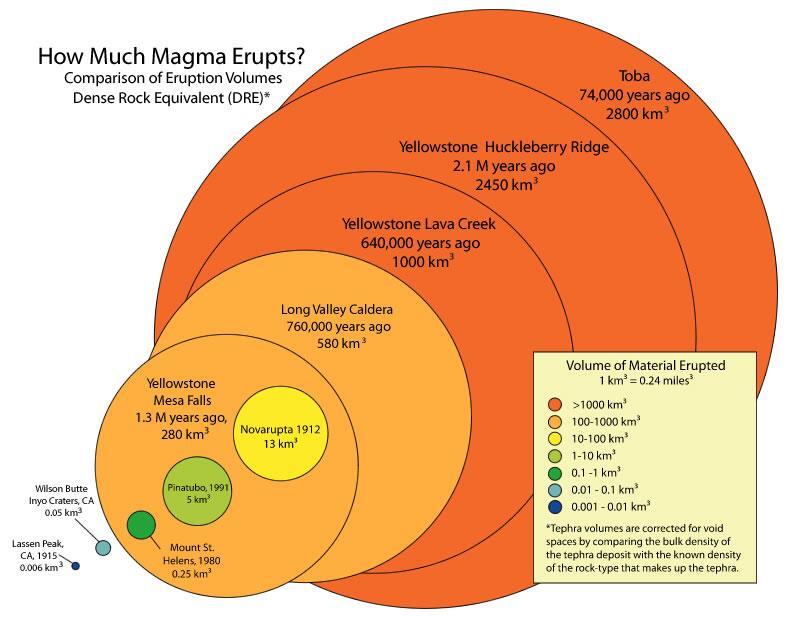
Supervolcano eruptions are extremely rare in Earth history. It’s a good thing because they are unimaginably large. A supervolcano must erupt more than 1,000 cubic km (240 cubic miles) of material, compared with 1.2 km3 for Mount St. Helens or 25 km3 for Mount Pinatubo, a large eruption in the Philippines in 1991. Not surprisingly, supervolcanoes are the most dangerous type of volcano. Supervolcanoes are a fairly new idea in volcanology. The exact cause of supervolcano eruptions is still debated, however, scientists think that a very large magma chamber erupts entirely in one catastrophic explosion. This creates a huge hole or caldera into which the surface collapses.
The largest supervolcano in North America is beneath Yellowstone National Park in Wyoming. Yellowstone sits above a hotspot that has erupted catastrophically three times: 2.1 million, 1.3 million, and 640,000 years ago. Yellowstone has produced many smaller (but still enormous) eruptions more recently. Fortunately, current activity at Yellowstone is limited to the region’s famous geysers.
Long Valley Caldera, south of Mono Lake in California, is the second largest supervolcano in North America. Long Valley had an extremely hot and explosive rhyolite explosion about 700,000 years ago. An earthquake swarm in 1980 alerted geologists to the possibility of a future eruption, but the quakes have since calmed down.
A supervolcano could change life on Earth as we know it. Ash could block sunlight so much that photosynthesis would be reduced and global temperatures would plummet. Volcanic eruptions could have contributed to some of the mass extinctions in our planet’s history. No one knows when the next super eruption will be.
VOLCANIC LANDFORMS AND GEOTHERMAL ACTIVITY
VOLCANIC LANDFORMS AND VENTS
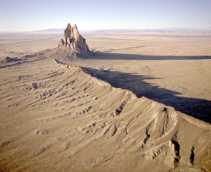
Volcanoes are associated with many types of landforms. The landforms vary with the composition of the magma that created them. Hot springs and geysers are also examples of surface features related to volcanic activity.
The most obvious landforms created by lava are volcanoes, most commonly as cinder cones, composite volcanoes, and shield volcanoes or eruptions that take place through fissures. The eruptions that created the entire ocean floor are essentially fissure eruptions. Magma intrusions ALSO can create landforms. The image on the right is of Shiprock in New Mexico, which is the neck of an old volcano that has eroded away.
A lava plateau forms when large amounts of fluid lava flows over an extensive area. When the lava solidifies, it creates a large, flat surface of igneous rock. Lava creates new land as it solidifies on the coast or emerges from beneath the water. Over time the eruptions can create whole islands. The Hawaiian Islands are formed from shield volcano eruptions that have grown over the last 5 million years.
HOT SPRINGS AND GEYSERS
Water sometimes comes into contact with hot rock. The water may emerge at the surface as either a hot spring or a geyser. Water heated below ground that rises through a crack to the surface creates a hot spring. The water in hot springs may reach temperatures in the hundreds of degrees Celsius beneath the surface, although most hot springs are much cooler.
There are several hazards that volcanic activity can produce.
- Eruption clouds occur when massive quantities of ash is ejected into the atmosphere where it can reach heights of 50,000 feet. Eruption clouds have proven to be very dangerous for aviation jets because the ash can shut down the engines. The ash cloud can also be very hazardous in terms of air pollution.
- Lahars are volcanic mudflows. Lahars are very dangerous because they do not require a volcanic eruption yet can travel hundreds of miles. All that is required is loose pyroclastic material on the volcano that mixes with precipitation or melting snow.
- Lava flows are layers of molten rock that flow over the surface, later cooling and solidifying.
- Lava bombs are large chunks of pyroclastic material ejected from a volcano. Larger pyroclastic material is called blocks.
- Pyroclastic flows are some of the most dangerous hazards caused by composite volcanoes. Pyroclastic flows are superheated clouds of pyroclastic material (e.g. hot rock and tephra) ranging in size from small rocks to the size of houses that are over 1,000 degrees F traveling down a mountain at speeds up to 100 mph.
- Tephra (or volcanic ash) is fine particles of pyroclastic material that can be carried thousands of miles away by prevailing winds. Regions hundreds of miles away could suffer collapsed buildings is the falling ash accumulates enough. Tephra can also cool the entire planet if enough is ejected into the atmosphere.
- Poisonous gases such as carbon dioxide, carbon monoxide, and sulfur dioxide can travel down a volcano and asphyxiate (suffocating) wildlife and humans. In 1986, an invisible cloud of carbon dioxide traveled down a volcano in Africa asphyxiating 1,742 people and 3,000 cattle.
There are actually many benefits to volcanic activity. One of the major benefits is the fact that volcanic activity can create very fertile soil for agriculture. The problem is that many civilizations developed near volcanoes for this reason – with sometimes deadly effects. Volcanic activity can also create many mineral resources such as gold, sliver, nickel, copper, and lead. Volcanic rock is often used for landscaping, tile, and cement.
Some of the most amazing landscapes are near volcanoes. This is because volcanic activity builds land creating breathtaking scenery. So volcanoes are economically vital for many regions because of the recreational activity and tourism they bring.
Finally, a new but important trend is geothermal power. The heat generated by volcanoes can create electricity to power civilization. Geothermal power is a completely renewable resource free of pollution and energy dependency on fossil fuels. Iceland – the surface manifestation of the mid-Atlantic ridge – has a goal of powering the entire nation on geothermal energy. Geothermal energy is also being used in California, Kilauea, Hawaii, and now Utah.


