8 Climate: Components and Controls
LEARNING OUTCOMES
- Explain the controlling factors of global climates.
- Describe the various global climates and biomes classified using the Köppen Classification System.
- Analyze Earth’s climatic past and how scientists measure and collect climate data.
- Describe the causes of short-term and long-term climate change.
- Determine why the overwhelming majority of scientists believe the current warming of the planet is because of human activity.
ESSENTIAL QUESTIONS
- In what ways does climate influence regional culture?
- What impacts could a changing climate have on local, regional, and international social, economic, and geopolitical stability?
- Should global environmental issues like climate change be resolved by individuals, nations, or international institutions like the United Nations?
- What is your worldview on global environmental issues and how they should be addressed?
Controls of Climate: LACEMOPS
Although almost anything can happen with the weather, climate is more predictable. The weather on a particular winter day in San Diego may be colder than on the same day in Lake Tahoe, but, on average, Tahoe’s winter climate is significantly colder than San Diego’s. Climate then is the long-term average of weather. Good climate is why we choose to vacation in Hawaii in February, even though the weather is not guaranteed to be good!
Climate is the average of weather in that location over a long period of time, usually for at least 30 years. A location’s climate can be described by its air temperature, humidity, wind speed and direction, and the type, quantity, and frequency of precipitation. Climate can change, but only over long periods of time. The climate of a region depends on its position relative to many things. These factors are described in the next sections.
A useful mnemonic device for remembering all the major influences is LACEMOPS. These are the same factors influencing weather, but over a long period of time.
LACEMOPS
- Latitude
- Air Masses
- Continentality
- Elevation
- Mountain barriers (orographic effect)
- Ocean Currents
- Pressure Systems
- Storm Tracks
LATITUDE
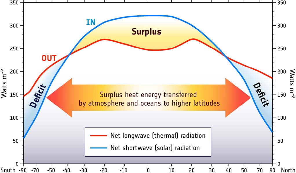
The main factor influencing the climate of a region is latitude because different latitudes receive different amounts of solar radiation. To review from the Earth’s Atmosphere chapter:
- The equator receives the most solar radiation. Days are equally long year-round and the sun is just about directly overhead at midday.
- The polar regions receive the least solar radiation. The night lasts six months during the winter. Even in summer, the sun never rises very high in the sky. Sunlight filters through a thick wedge of atmosphere, making the sunlight much less intense. The high albedo, because of ice and snow, reflects a good portion of the sun’s light.
ATMOSPHERIC CIRCULATION & Air Masses
Recall from the Earth’s Atmosphere chapter the circulation cells and global wind belts. The position of a region relative to the circulation cells and wind belts has a great effect on its climate. In an area where the air is mostly rising or sinking, there is not much wind.
The Intertropical Convergence Zone (ITCZ)
is the low pressure area near the equator in the boundary between the two Hadley Cells. The air rises so that it cools and condenses to create clouds and rain. Climate along the ITCZ is therefore warm and wet. Early mariners called this region the doldrums because their ships were often unable to sail because there were no steady winds.
The ITCZ migrates slightly with the season. Land areas heat more quickly than the oceans. Because there are more land areas in the Northern Hemisphere, the ITCZ is influenced by the heating effect of the land. In Northern Hemisphere summer, it is approximately 5o north of the equator while in the winter it shifts back and is approximately at the equator. As the ITCZ shifts, the major wind belts also shift slightly north in summer and south in winter, which causes the wet and dry seasons in this area.
HADLEY CELL AND FERRELL CELL BOUNDARIES
At about 30 °N and 30 °S, the air is fairly warm and dry because much of it came from the equator where it lost most of its moisture at the ITCZ. At this location the air is descending, and sinking air warms and causes evaporation. Mariners named this region the horse latitudes. Sailing ships were sometimes delayed for so long by the lack of wind that they would run out of water and food for their livestock. Sailors tossed horses and other animals over the side after they died. Sailors sometimes didn’t make it either.
PREVAILING WINDS
The prevailing winds are the bases of the Hadley, Ferrell, and Polar Cells. These winds greatly influence the climate of a region because they bring the weather from the locations they come from. For example, in California, the predominant winds are the westerlies blowing in from the Pacific Ocean, which bring in relatively cool air in summer and relatively warm air in winter. Local winds also influence local climate. For example, land breezes and sea breezes moderate coastal temperatures.
CONTINENTAL POSITION
When a particular location is near an ocean or large lake, the body of water plays an extremely important role in affecting the region’s climate.
- A maritime climate is strongly influenced by the nearby sea. Temperatures vary a relatively small amount seasonally and daily. For a location to have a true maritime climate, the winds must most frequently come off the sea.
- A continental climate is more extreme, with greater temperature differences between day and night and between summer and winter.
The ocean’s influence in moderating climate can be seen in the following temperature comparisons. Each of these cities is located at 37 °N latitude, within the westerly winds.
ELEVATION
MOUNTAIN RANGES
Air pressure and air temperature decreases with altitude. The closer molecules are packed together, the more likely they are to collide. Collisions between molecules give off heat, which warms the air. At higher altitudes, the air is less dense and air molecules are more spread out and less likely to collide. A location in the mountains has lower average temperatures than one at the base of the mountains. In Colorado, for example, Lakewood (5,640 feet) average annual temperature is 62 °F (17 °C), while Climax Lake (11,300 feet) is 42 °F (5.4 °C).
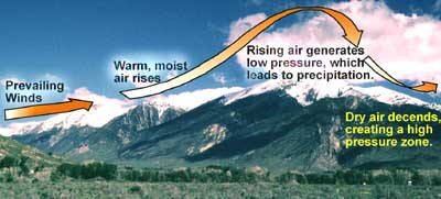
Mountain ranges have two effects on the climate of the surrounding region. The first is something called the rainshadow effect, which brings warm dry climate to the leeward size of a mountain range, was described in the Earth’s Atmosphere chapter.
The second effect mountains have on climate systems is the ability to separate coastal regions from the rest of the continent. Since a maritime air mass may have trouble rising over a mountain range, the coastal area will have a maritime climate but the inland area on the leeward side will have a continental climate.
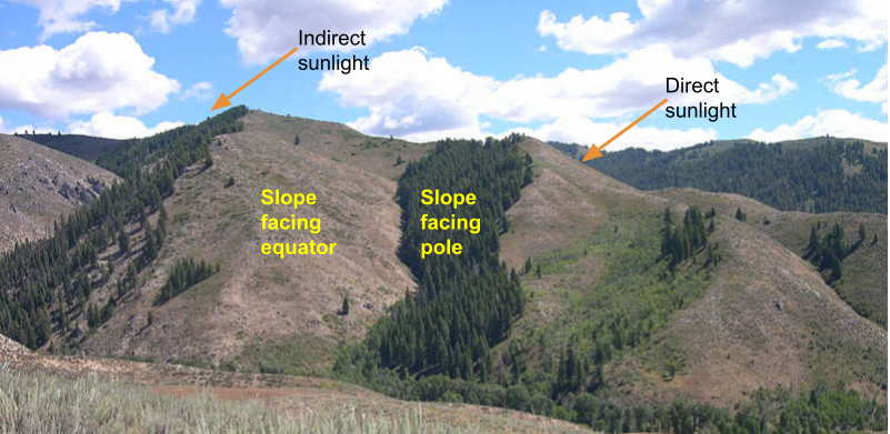
Mountains and valleys also influence the aspect of slopes. A steep slope that faces towards the equator (if you stand on the slope, looking downhill, you’re also facing the equator) will have more direct sunlight that the slope on the opposite side of the ridge behind or the slope across the valley from you. Because there’s more direct sunlight the soils warm up more and there’s more evapotranspiration from plants. In some marginal environments, the difference in ET can have a significant role on the type of vegetation on nearby slopes with different slope aspects.
OCEAN CURRENTS
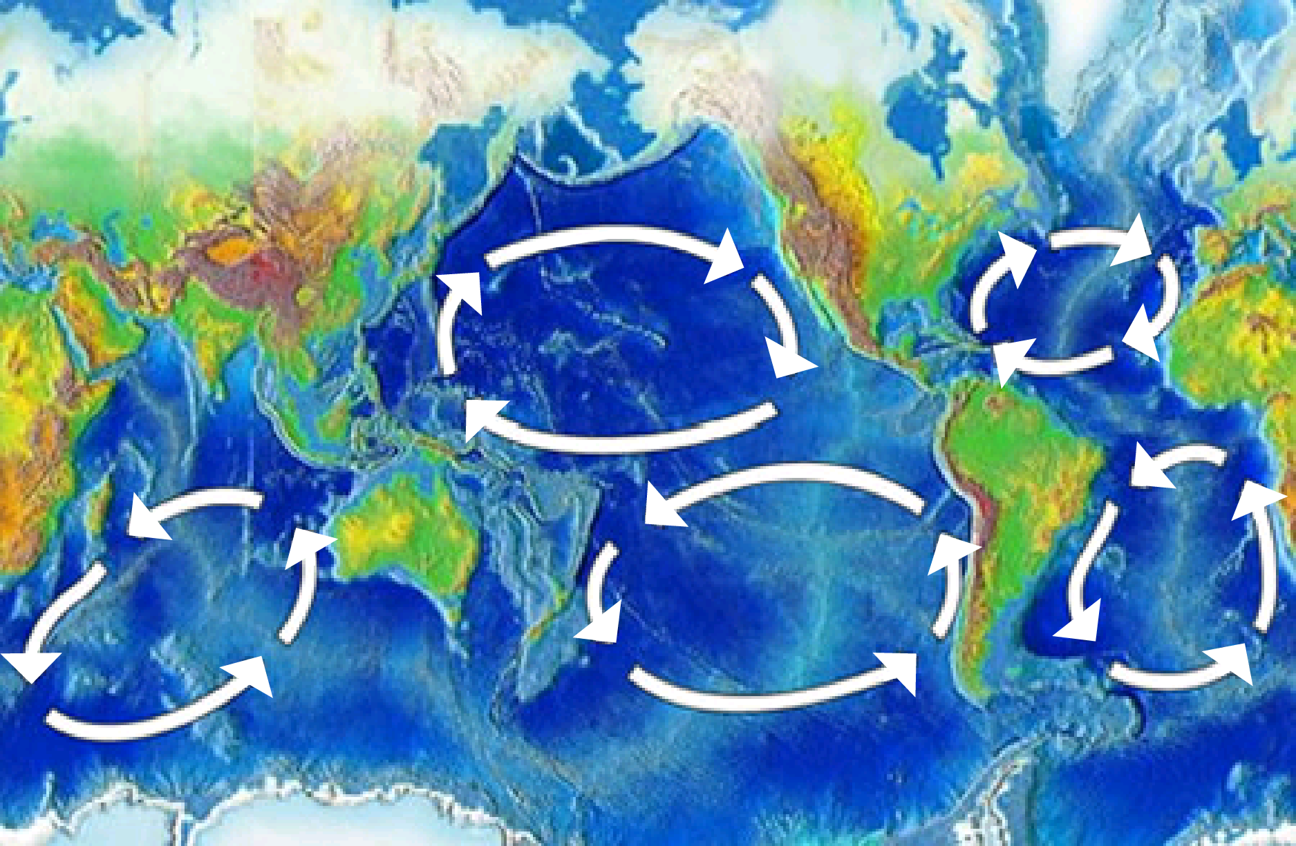 The temperature of the water offshore influences the temperature of a coastal location, particularly if the winds come off the sea. The cool waters of along the western United States is caused by a clockwise rotating ocean current that is bringing cold water from the arctic toward the equator. The climatic effect is that coastal regions of California, Oregon, and Washington are are cool. Coastal upwelling also brings cold, deep water up to the ocean surface off of California, which contributes to the cool coastal temperatures. But that same ocean current brings warm, tropical water to eastern Japan.
In the Atlantic Ocean, the northern ocean current, called the Gulf Stream, brings warm water from the tropics to the southern states. This is a major reason why the southern states experience humid conditions in the summer and tornadoes because of all this warm moisture. The Gulf Stream also impacts Europe by bringing warm water northward, making this region that is rather northward warmer than expected.
PRESSURE SYSTEMS
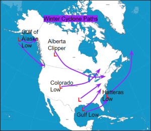
STORM TRACKS
Winter storms in North America tend to follow one of a half dozen common tracks.
Climate Zones and Biomes
A climate zone results from the climate conditions of an area: its temperature, humidity, amount and type of precipitation, and the season. A climate zone is reflected in a region’s natural vegetation. Perceptive travelers can figure out which climate zone they are in by looking at the vegetation, even if the weather is unusual for the climate on that day.
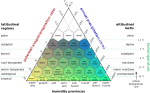
The major factors that influence climate determine the different climate zones. In general, the same type of climate zone will be found at similar latitudes and in similar positions on nearly all continents, both in the Northern and Southern Hemispheres. The one exception to this pattern is the climate zones called the continental climates, which are not found at higher latitudes in the Southern Hemisphere. This is because the Southern Hemisphere land masses are not wide enough to produce a continental climate.
