9 Koppen Climate Zones
The most common system used to classify climatic zones is the Köppen classification system. This system is based on the temperature, the amount of precipitation, and the times of year when precipitation occurs. Since climate determines the type of vegetation that grows in an area, vegetation is used as an indicator of climate type. A climate type, together with its plants and animals make up a biome. The organisms of a biome share certain characteristics around the world, because their environment has similar advantages and challenges. The organisms have adapted to that environment in similar ways over time. For example, different species of cactus live on different continents, but they have adapted to the harsh desert in similar ways.
For recent climate, over the last 100 years or so, we look at average weather conditions over 30 years periods. The zones are updated when a new 30 year period ends. One small part of climate change study looks and compares how zones have shifted over one period to another.
Zones Overview
Zones are lettered alphabetically with capital letters starting at the equator and moving to the poles.
A: Near the equator
B: Roughly 20-30°N or S and corresponding to Sub-Tropical High pressure regions
C: Mid-latitude regions, on the equator side. Humid and warm
D: Mid-latitude regions trending to polar. Cool to cold
E: Sub-polar and polar regions. Cold
H: Highland. Used when map scale can’t clearing show several different zones in close proximity.
Those zones are further refined with a second or third letter, in lower case:
Second letter: clarifies precipitation patterns
- f – wet year-round
- s – dry summer season
- w – dry winter season
- m – monsoon
Third letter clarifies temperatures patterns
- a – hot summer
- b – warm summer
- c – cool summer
- d – very cold winters
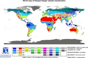
The Köppen classification system recognizes five major climate groups, each with a distinct capital letter A through E. They are alphabetical, starting near the equator and heading to the poles. Each lettered group is divided into subcategories. Some of these subcategories are forest (f), monsoon (m), and wet/dry (w) types, based on the amount of precipitation and season when that precipitation occurs. The next section covers each climate zone in more detail.
Tropical Moist Climates (Group A)

Tropical Moist (Group A) climates are found in a band about 15° to 25° N and S of the equator. Tropical moist climates have these characteristics:
- Temperature: Intense sunshine; each month has an average temperature of at least 18°C (64°F).
- Rainfall: Abundant, at least 150 cm (59 inches) per year.
The wet tropics have almost no annual temperature variation and tremendous amounts of rain fall year round, between 175 and 250 cm (65 and 100 inches). These conditions support the tropical rainforest biome. Tropical rainforests are dominated by densely packed, broadleaf evergreen trees. These rainforests have the highest number of species or biodiversity of any ecosystem.
TROPICAL MONSOON (Am)
The tropical monsoon climate has very low precipitation for one to two months each year. Rainforests grow here because the dry period is short, and the trees survive off of soil moisture. This climate is found where the monsoon winds blow, primarily in southern Asia, western Africa, and northeastern South America.
TROPICAL WET AND DRY
The tropical wet and dry climate lies between about 5° and 20° latitude, around the location of the ITCZ. In the summer, when the ITCZ drifts northward, the zone is wet. In the winter, when the ITCZ moves toward the equator, the region is dry. This climate exists where strong monsoon winds blow from land to sea, such as in India.
Rainforests cannot survive the months of low rainfall, so the typical vegetation is savanna. This biome consists mostly of grasses, with widely scattered deciduous trees and rare areas of denser forests.
Dry Climates (Group B)
The Dry Climates (Group B) have less precipitation than evaporation. Dry climate zones cover about 26% of the world’s land area. This zone is mostly identified as dry. The total potential evaporation and transpiration are greater than the actual precipitation.
- Temperature: Abundant sunshine. Summer temperatures are high; winters are cooler and longer than Tropical Moist climates
- Rainfall: Irregular; several years of drought are often followed by a single year of abundant rainfall
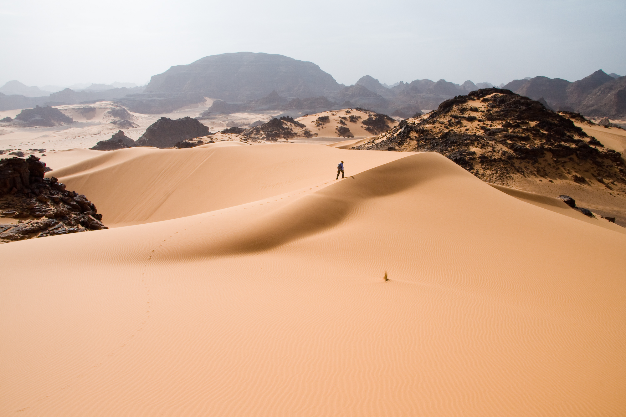
ARID DESERT (Bw)
Low-latitude, arid deserts are found between 15° to 30° N and S latitudes. This is where warm dry air sinks at high pressure zones. True deserts make up around 12% of the world’s lands. In the Sonoran Desert of the southwestern United States and northern Mexico, skies are clear. The typical weather is extremely hot summer days and cold winter nights. Although annual rainfall is less than 25 cm (10 inches), rain falls during two seasons. Pacific storms bring winter rains and monsoons bring summer rains. Since organisms do not have to go too many months without some rain, a unique group of plants and animals can survive in the Sonoran desert.
SEMI-ARID OR STEPPE (Bs)
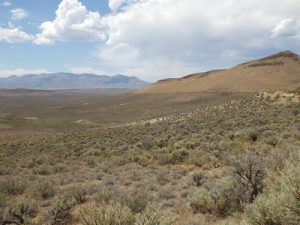
Higher latitude semi-arid deserts, also called steppe, are found in continental interiors or in rainshadows. Semi-arid deserts receive between 20 and 40 cm (8 to 16 inches) of rain annually. The annual temperature range is large. In the United States, the Great Plains, portions of the southern California coast, and the Great Basin are semi-arid deserts.
Moist Subtropical Mid-latitude (Group C)
Type C climates are warm and humid.
- Temperature: The coldest month ranges from just below freezing to almost balmy, between -3°C and 18°C (27° to 64°F). Summers are mild with average temperatures above 10°C (50°F). Seasons are distinct.
- Rainfall: There is plentiful annual rainfall.
DRY SUMMER SUBTROPICAL OR MEDITERRANEAN CLIMATES (Cs)
The Dry Summer Subtropical climate is found on the western sides of continents between 30° and 45° latitude. Annual rainfall is 30 to 90 cm (14 to 35 inches), most of which comes in the winter.
The climate is typical of coastal California, which sits beneath a summertime high pressure for about five months each year. Land and sea breezes make winters moderate and summers cool. Vegetation must survive long summer droughts. The scrubby, woody vegetation that thrives in this climate is called chaparral.
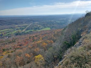
HUMID SUBTROPICAL (Cfa)
The Humid Subtropical climate zone is found mostly on the eastern sides of continents. Rain falls throughout the year with annual averages between 80 and 165 cm (31 and 65 inches). Summer days are humid and hot, from the lower 30’s up to 40°C (mid-80’s up to 104°F). Afternoon and evening thunderstorms are common. These conditions are caused by warm tropical air passing over the hot continent. Winters are mild, but middle-latitude storms called cyclones may bring snow and rain. The southeastern United States, with its hot humid summers and mild, but frosty winters, is typical of this climate zone.
MARINE WEST COAST CLIMATE (Cfb)
This climate lines western North America between 40° and 65° latitude, an area known as the Pacific Northwest. Ocean winds bring mild winters and cool summers. The temperature range, both daily and annually, is fairly small. Rain falls year round, although summers are drier as the jet stream moves northward. Low clouds, fog, and drizzle are typical. In Western Europe the climate covers a larger region since no high mountains are near the coast to block wind blowing off the Atlantic.
Humid Continental (Group D)
Continental (Group D) climates are found in most of the North American interior from about 40°N to 70°N. What climate characteristics is the continental group most likely to have?
- Temperature: The average temperature of the warmest month is higher than 10°C (50°F) and the coldest month is below -3°C (-27°F).
- Precipitation: Winters are cold and stormy (look at the latitude of this zone and see if you can figure out why). Snowfall is common and snow stays on the ground for long periods of time.
Trees grow in continental climates, even though winters are extremely cold, because the average annual temperature is fairly mild. Continental climates are not found in the Southern Hemisphere because of the absence of a continent large enough to generate this effect.
HUMID CONTINENTAL (Dfa, Dfb)
The humid continental climates are found around the polar front in North America and Europe. In the winter, middle-latitude cyclones bring chilly temperatures and snow. In the summer, westerly winds bring continental weather and warm temperatures. The average July temperature is often above 20°C (70°F). The region is typified by deciduous trees, which protect themselves in winter by losing their leaves.
The two variations of this climate are based on summer temperatures.
- Dfa, long, hot summers: summer days may be over 38°C (100°F), nights are warm and the temperature range is large, perhaps as great as 31°C (56°F). The long summers and high humidity foster plant growth.
- Dfb, long, cool summers: summer temperatures and humidity are lower. Winter temperatures are below -18°C (0°F) for long periods.
SUBPOLAR (Dfc)
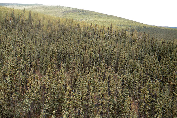
The subpolar climate is dominated by the continental polar air that masses over the frigid continent. Snowfall is light, but cold temperatures keep snow on the ground for months. Most of the approximately 50 cm (20 inches) of annual precipitation falls during summer cyclonic storms. The angle of the Sun’s rays is low but the Sun is visible in the sky for most or all of the day during the summer, so temperatures may get warm, but are rarely hot. These continental regions have extreme annual temperature ranges. The boreal, coniferous forests found in the subpolar climate are called taiga and have small, hardy, and widely spaced trees. Taiga vast forests stretch across Eurasia and North America.
Polar Climates (Group E)
Polar climates are found across the continents that border the Arctic Ocean, Greenland, and Antarctica. What climate characteristics is the polar climate group most likely to have?
- Temperature: Winters are entirely dark and bitterly cold. Summer days are long, but the sun is low on the horizon so summers are cool. The average temperature of the warmest month at less than 10°C (50°F). The annual temperature range is large.
- Precipitation: The region is dry with less than 25 cm (10 inches) of precipitation annually; most precipitation occurs during the summer.
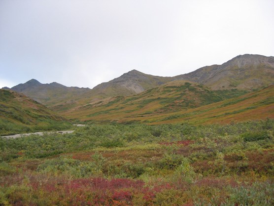
POLAR TUNDRA (ET)
The polar tundra climate is continental, with severe winters. Temperatures are so cold that a layer of permanently frozen ground, called permafrost forms below the surface. This frozen layer can extend hundreds of meters deep. The average temperature of the warmest months is above freezing, so summer temperatures defrost the uppermost portion of the permafrost. In winter, the permafrost prevents water from draining downward. In summer, the ground is swampy. Although the precipitation is low enough in many places to qualify as a desert, evaporation rates are also low, so the landscape receives more usable water than a desert. Because of the lack of ice-free land near the South Pole, there is very little tundra in the Southern Hemisphere. The only plants that can survive the harsh winters and soggy summers are small ground-hugging plants like mosses, lichens, small shrubs, and scattered small trees that make up the tundra.
ICE CAP
Ice caps are found mostly on Greenland and Antarctica, about 9% of the Earth’s land area. Ice caps may be thousands of meters thick. Ice cap areas have extremely low average annual temperatures, e.g. -29°C (-20°F) at Eismite, Greenland. Precipitation is low because the air is too cold to hold much moisture. Snow occasionally falls in the summer.
Highland Climates (Group H)
When climate conditions in a small area are different from those of the surroundings, the climate of the small area is called a microclimate. The microclimate of a valley may be cool relative to its surroundings since cold air sinks. The ground surface may be hotter or colder than the air a few feet above it, because rock and soil gain and lose heat readily. Different sides of a mountain will have different microclimates. In the Northern Hemisphere, a south-facing slope receives more solar energy than a north-facing slope, so each side supports different amounts and types of vegetation. Altitude mimics latitude in climate zones. Climates and biomes typical of higher latitudes may be found in other areas of the world at high altitudes. A short distance up a mountain results in significant climate change compared to travelling the same distance on flat plains.
