Want to create or adapt books like this? Learn more about how Pressbooks supports open publishing practices.
5 Movement in the Atmosphere
Air movement is classified as horizontal or vertical. The definition of wind is horizontal air movement. Updrafts and downdrafts are vertical movements. Vertical air movement is much slower than horizontal movement, generally one to two orders of magnitude slower. Winds are a combination of air pressure difference, friction, and the Coriolis effect. The Coriolis effect is the apparent motion of the wind due to the rotation of the earth. Local topography can have significant influence on local winds and local climate. Global wind patterns move energy in reliable patterns over long distances.
Air Pressure
Natural processes are always moving energy from high concentration to low concentration. Material at the top of a mountain has great potential energy so natural processes generally move that material to the valley bottom which has less potential energy. Air movement happens because there is an uneven distribution of energy in the atmosphere. The energy can be in several forms or expressed in several ways such as heat, humidity, kinetic, potential among others.
Air pressure is the force the atoms and molecules that make up the various layers of the atmosphere exert on a surface as they constantly moving in random directions. Each molecule is too small to feel and only exerts a tiny bit of force. However, when we sum the total forces from the large number of molecules that strike a surface each moment, then the total observed pressure can be considerable.
Air pressure can be increased or decreased in one of two ways. First, simply adding molecules to a container will increase the pressure because a larger number of molecules will increase the number of collisions with the container’s boundary. This is observed as an increase in pressure. A good example of this is adding or subtracting air in an automobile tire. By adding air, the number of molecules increases, as does the total number of the collisions with the tire’s inner boundary. The increased number of collisions increases the pressure and forces the tire to expand in size.
The second way of changing air pressure is by the addition or subtraction of heat. Adding heat to a container can transfer energy to air molecules. Heated molecules move with increased velocity, striking the container’s boundary with greater force, which is observed as an increase in pressure.
Since molecules move in all directions, they can even exert air pressure upwards as they smash into object from underneath. In the atmosphere, air pressure can be exerted in all directions.
As elevation increases, the number of molecules decreases and the density of air therefore is less, which means there is a decrease in air pressure. In fact, while the atmosphere extends hundreds of miles up, one half of the air molecules in the atmosphere are contained within the first 18,000 feet (5.6 km). This decrease in pressure with height makes it very hard to compare the air pressure at ground level from one location to another, especially when the elevations of each site differ. Therefore, to give meaning to the pressure values observed at each station, we convert the station air pressures reading to a value with a common denominator.
The common denominator we use is the sea-level elevation pressure. At observation stations around the world, the air pressure reading, regardless of the observation station elevation, is converted to a value that would be observed if that instrument were located at sea level. The two most common units in the United States to measure the pressure are “Inches of Mercury” and “Millibars”. Inches of mercury refers to the height of a column of mercury measured in hundredths of inches. This is what you will usually hear from the NOAA Weather Radio or from your favorite weather or news source. At sea level, standard air pressure is 29.92 inches of mercury, 14.7 pounds per square inch.
In this class we’ll more often use units of millibars. The term comes from the original term for pressure: “bar”. Bar is from the Greek “báros”, meaning weight. A millibar is 1/1000th of a bar and is approximately equal to 1000 dynes (one dyne is the amount of force it takes to accelerate an object with a mass of one gram at the rate of one centimeter per second squared). Millibar values used in meteorology range from about 100 to 1050. At sea level, standard air pressure in millibars is 1013.2. Weather maps showing the pressure at the surface are drawn using millibars.
Although the changes are usually too slow to observe directly, air pressure is almost always changing. This change in pressure is caused by changes in air density, and air density is related to temperature.
Warm air is less dense than cooler air because the gas molecules in warm air have a greater velocity and are farther apart than in cooler air. So, while the average altitude of the 500 millibar level is around 18,000 feet (5,600 meters) the actual elevation will be higher in warm air than in cold air.
How temperature affects the height of pressure.
The most basic change in pressure is the twice daily rise and fall due to the heat from the sun. Each day, the pressure is at its lowest around 4 a.m./p.m., and at its highest around 10 a.m./p.m. The magnitude of the daily cycle is greatest near the equator, decreasing toward the poles.
On top of the daily fluctuations are the larger pressure changes as a result of the migrating weather systems. These weather systems are identified by the blue H’s and red L’s seen on weather maps.
How are changes in weather related to changes in pressure?
From his vantage point in England in 1848, Rev. Dr. Brewer wrote in his A Guide to the Scientific Knowledge of Things Familiar the following about the relation of pressure to weather:
The FALL of the barometer (decreasing pressure)
In very hot weather, the fall of the barometer denotes thunder. Otherwise, the sudden falling of the barometer denotes high wind.
In frosty weather, the fall of the barometer denotes thaw.
If wet weather happens soon after the fall of the barometer, expect but little of it.
In wet weather if the barometer falls expect much wet.
In fair weather, if the barometer falls much and remains low, expect much wet in a few days, and probably wind.
The barometer sinks lowest of all for wind and rain together; next to that wind, (except it be an east or north-east wind).
The RISE of the barometer (increasing pressure)
In winter, the rise of the barometer presages frost.
In frosty weather, the rise of the barometer presages snow.
If fair weather happens soon after the rise of the barometer, expect but little of it.
In wet weather, if the mercury rises high and remains so, expect continued fine weather in a day or two.
In wet weather, if the mercury rises suddenly very high, fine weather will not last long.
The barometer rises highest of all for north and east winds; for all other winds it sinks.
The barometer UNSETTLED (unsteady pressure)
If the motion of the mercury be unsettled, expect unsettled weather.
If it stands at “MUCH RAIN” and rises to “CHANGEABLE” expect fair weather of short continuance.
If it stands at “FAIR” and falls to “CHANGEABLE”, expect foul weather.
Its motion upwards, indicates the approach of fine weather; its motion downwards, indicates the approach of foul weather.
These pressure observations hold true for many other locations as well, but not all of them. Storms that occur in England, located near the end of the Gulf Stream, bring large pressure changes. In the United States, the largest pressure changes associated with storms will generally occur in Alaska and the northern half of the continental U.S. In the tropics, except for tropical cyclones, there is very little day-to-day pressure change, and none of the rules apply.
To summarize, warm air has more energy than cool air. The energy is in the form of heat and humidity. The warm rising creates a low pressure zone at the ground. Air from the surrounding area moves into the space left by the rising air. The rising air reaches an altitude of energy equilibrium, then flows horizontally in the upper troposphere. Horizontal flow is called advection.
Cool air descends. Where the descending air reaches the ground, it creates a high pressure zone. Air flowing from areas of high pressure to low pressure creates winds. The greater the pressure difference between the pressure zones, and the closer together they are, the faster the wind flow.
The difference in air pressure, which initiates air movement, is the pressure gradient force. Once the air is moving, two additional factors influence the direction of air flow. First, all movement is slowed because of friction. Second, air movement over long distances is influenced by the Coriolis effect. This gives a total of three components that influence wind direction over long distances.
Air moves from high to low pressure.
Coriolis Effect deflects winds to the right in the northern hemisphere, to the left in the southern hemisphere. At the equator, the earth is rotating 1000 mph, but more slowly as you get closer to the poles.
The Coriolis effect happens because the fluid air moves at a different speed than the solid earth. At the equator the earth is moving at about 1000 miles per hour. (Circumference is about 24,000 miles, 24 hours per day, so speed is about 1000 mile per hour). But the speed slows as you near the poles. (Draw a circle 1 m in diameter centered on the north pole and the circumference is 3.14 m so the rotational speed is 3.14 m per day, not even per hour). Air moving from the tropics towards the equator comes from a region where the earth moves more slowly and arrives at a region where the earth is moving at its greatest speed. Therefore the earth near the equator moves faster than the arriving air. Since the earth rotates from the west to the east but the air doesn’t move as fast (because of insufficient friction) the air actually gets left behind the earth. Humans, however, are solid and move the same speed as the earth so we feel an apparent wind from the east to the west. The general air flow near the equator is from east to west, which is why hurricanes move from Africa to the Caribbean. Going the other direction, air moving from the tropics towards the poles leaves a region that is rotating relatively quickly and arrives at a slower region. Here the air moves generally from the west to the east. In most of the US and Europe our weather comes from the west. These winds are the prevailing westerlies. In the northern hemisphere air appears to be deflected to the right of its initial destination. In the southern hemisphere air is deflected to the left.
Winds are:
Horizontal air flow, not vertical
Influenced by
1) pressure gradient force,
2) friction,
3) Coriolis effect
Named by the direction they come from
H represent the locations of the areas of highest pressure. L represent the positions of the lowest pressure. Brown lines are isobars of equal barometric pressure.
Drafts happen because of uneven heating and humidity creating air parcels with different density in a local area. This difference in density creates updrafts and downdrafts which circulate as convection cells. Warmer air holds more water vapor and water molecules have less mass than nitrogen and oxygen molecules so warm, moist air rises while cool, dry air sinks. Convection in the atmosphere creates the planet’s weather. When warm air rises and cools in a low pressure zone, it may not be able to hold all the water it contains as vapor. Some water vapor may condense to form clouds or precipitation. When cool air descends, it warms (like the brakes on a car). Since it can then hold more moisture, the descending air will evaporate water on the ground. Air moving between large high and low pressure systems creates the global wind belts that profoundly affect regional climate. These global scale are very important to economics, interaction among societies, climate and many other issues. We will return to Global Atmospheric Circulation, but first we’ll look at smaller, local pressure systems that create localized winds and affect the weather and climate of a local area.
When two air masses meet together, the boundary between the two is called a weather front. At a front, the two air masses have different densities, based on temperature and humidity, and do not easily mix. One air mass rises above the other, creating a low pressure zone. If the lifted air is moist, there will be condensation and precipitation. Winds are common at a front. The greater the temperature and humidity difference between the two air masses, the stronger the winds will be. Fronts are the main cause of stormy weather.
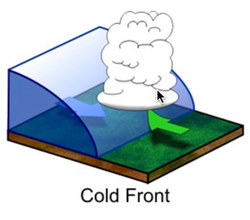
There are four types of fronts. Three are mobile and one is stationary. Fronts are named by the type of new arriving air mass. A cold front is when a cold air mass is displacing a warmer air mass.
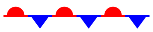
Weather map symbol for a Stationary Front
STATIONARY FRONTS
At a stationary front the air masses do not move. A front may become stationary if an air mass is stopped by a barrier, such as a mountain range. A stationary front may bring days of rain, drizzle, and fog. Winds usually blow parallel to the front, but in opposite directions. After several days, the front will likely break apart. (If the wind picks up documents and envelopes, it’s called a stationery front, not to be confused with a stationary front. 😊)
COLD FRONTS
Along the cold front, the denser, cold air pushes up the warm air, causing the air pressure to decrease. If the humidity is high enough, some types of cumulus clouds will grow. High in the atmosphere, winds blow ice crystals from the tops of these clouds to create cirrostratus and cirrus clouds. At the front, there will be a line of rain showers, snow showers, or thunderstorms with blustery winds. A squall line is a line of severe thunderstorms that forms along a cold front. Generally, a cold front has a steeper angle where the air masses meet and the warm air is forced up both high and faster. This creates tall clouds which quickly release energy in as small space. Expect brief downpours. Behind the front is the cold air mass. This mass is drier so precipitation stops. The weather may be cold and clear or only partly cloudy. Winds may continue to blow into the low pressure zone at the front. The weather at a cold front varies with the season.
spring and summer: The air is unstable so thunderstorms or tornadoes may form.
spring: If the temperature gradient is high, strong winds blow.
autumn: Strong rains fall over a large area.
winter: The cold air mass is likely to have formed in the frigid arctic so there are frigid temperatures and heavy snows.
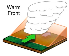
WARM FRONTS
Along a warm front, a warm air mass slides over a cold air mass. When warm, less dense air moves over the colder, denser air, the atmosphere is relatively stable. The transition from cold air to warm air takes place gradually over a long distance compared to a cold front so the first signs of changing weather appear long before the front is actually over you. Initially, the air is cold: the cold air mass is above you and the warm air mass is above it. High cirrus clouds mark the transition from one air mass to the other. Over time, cirrus clouds become thicker and cirrostratus clouds form. As the front approaches, altocumulus and altostratus clouds appear and the sky turns gray. In winter, snowflakes fall. The clouds thicken and nimbostratus clouds form. Snowfall increases. Winds grow stronger as the low pressure approaches. As the front gets closer, the cold air mass is just above you but the warm air mass is not too far above that. The weather worsens. As the warm air mass approaches, temperatures rise and snow turns to sleet and freezing rain. Warm and cold air mix at the front, leading to the formation of stratus clouds and fog.
Weather map symbol for an Occluded Front
OCCLUDED FRONTS
An occluded front usually forms around a low pressure system. The occlusion starts when a cold front catches up to a warm front. The air masses, in order from front to back, are cold, warm, and then cold again. The Coriolis Effect curves the boundary where the two fronts meet towards the pole. If the air mass that arrives third is colder than either of the first two air masses, that air mass slips beneath them both. This is called a cold occlusion. If the air mass that arrives third is warm, that air mass rides over the other air mass. This is called a warm occlusion.
The weather at an occluded front is especially fierce right at the occlusion. Precipitation and shifting winds are typical. A single occluded front in the fall and winter can impact a region from Hudson Bay to the Gulf Mexico and produce several feet of snow in severe cases.
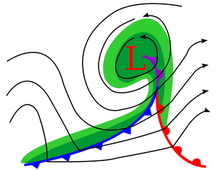
Cyclone (Low Pressure) in the Northern Hemisphere rotating counter-clockwise.
At the center of each air mass is typically a high pressure. Where these air masses meet is a weather front. When they meet, one mass rises and creates a local low pressure along the front. This means that weather is typically sunny within air masses, but their temperatures could vary with the season and humidity could vary based on the source region of the air mass.
More often than not, weather fronts are not isolated events. Often times, they are part of a larger rotating system called a mid-latitude cyclone. This type of cyclone will be discussed later in this chapter, but as an introduction it is a low pressure system that is usually mixing warmer air from the south (in the Northern Hemisphere) and colder air from the north.
Local Winds
Local winds result from air moving between small low and high pressure systems. The Coriolis effect is minimal over the shorter distances. High and low pressure cells are created by a variety of conditions. Some local winds have very important effects on the weather and climate of some regions.
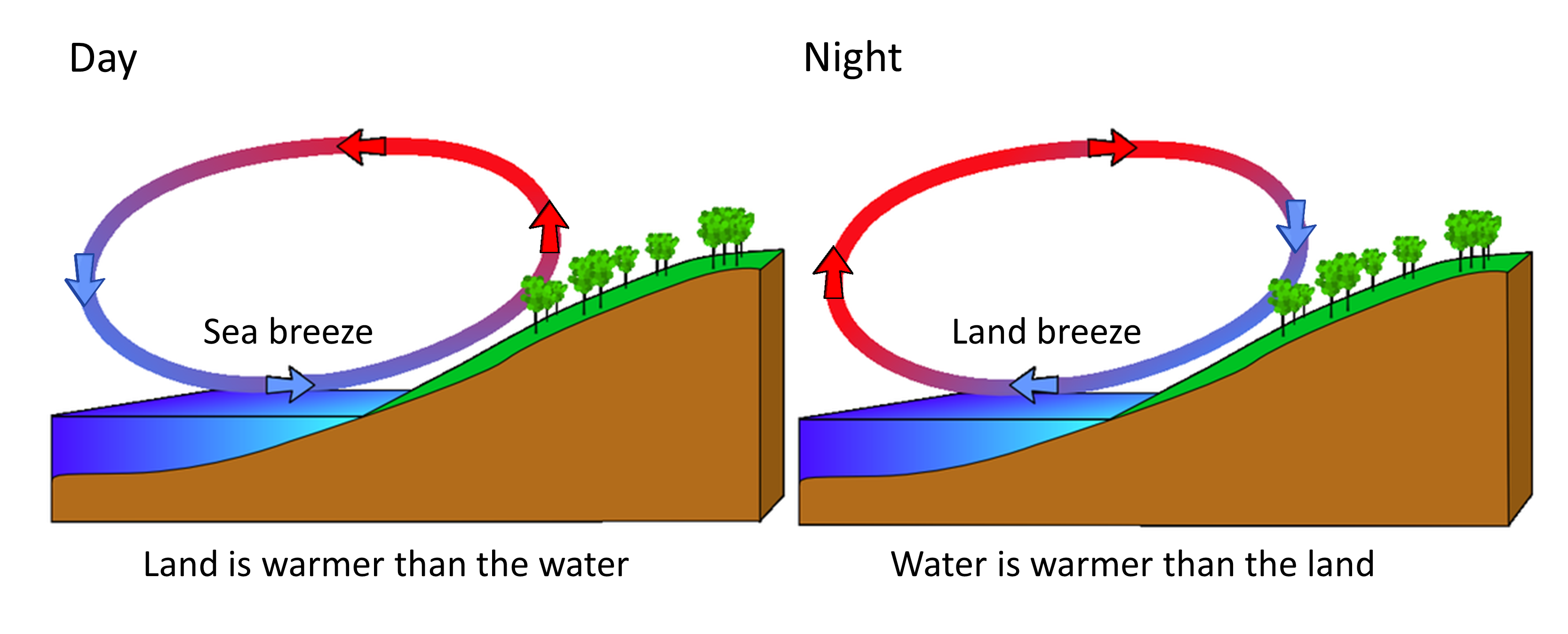
LAND AND SEA BREEZES
Sea Breezes (Day time) and Land Breezes (Night time)
Since water has a very high specific heat, it maintains its temperature well. So water heats and cools more slowly than land. If there is a large temperature difference between the surface of the sea (or a large lake) and the land next to it, high and low pressure regions form. This creates local winds. Sea breezes blow from the cooler ocean over the warmer land in summer. The image to the right depicts the situation during the late afternoon or generally during the summer. The land has warmed and conduction has transferred heat into the air over the land and creates low pressure on land. Sea breezes then blow onto shore at about 10 to 20 km (6 to 12 miles) per hour and lower air temperature much as 5 to 10°C (9 to 18°F).
Land breezes blow from the land to the sea in winter. The high and low pressure centers switch places so warmer air from the ocean rises and then sinks on land. Land and sea breezes create the pleasant climate for which Southern California is known. The effect of land and sea breezes are felt only about 50 to 100 km (30 to 60 miles) inland. This same cooling and warming effect occurs to a smaller degree during day and night, because land warms and cools faster than the ocean. The land breezes are significant in southern California in the fall because they bring fast moving, dry winds which dry out the vegetation and increase the risk of wildfire.
MOUNTAIN AND VALLEY BREEZES
Temperature differences between mountains and valleys create mountain and valley breezes. During the day, air on mountain slopes is heated more than air at the same elevation over an adjacent valley. As the day progresses, warm air rises and draws the cool air up from the valley, creating a valley breeze. At night the mountain slopes cool more quickly than the nearby valley, which causes a mountain breeze to flow downhill.
In the mountainous Western US, firefighters try to put out fires at night because the air is coming down slopes and is less likely to spread into new fuels.
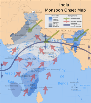
MONSOONAL WINDS
Monsoon winds are larger scale versions of land and sea breezes; they blow from the sea onto the land in summer and from the land onto the sea in winter. This seasonal reversal of wind direction is the true definition of a monsoon, even though most people think “monsoon” means only rain. Monsoon winds occur where very hot summer lands are next to the sea. Thunderstorms are common during monsoons. The most significant monsoon in the world occurs each year over the Indian subcontinent. More than two billion residents of India and southeastern Asia depend on monsoon rains for their drinking and irrigation water. Back in the days of sailing ships, seasonal shifts in the monsoon winds carried goods back and forth between India and Africa.
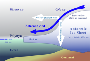
KATABATIC WINDS
Katabatic winds flow off the cold high elevation ice sheet to the lower warmer ocean.
Katabatic winds move up and down slopes, but they are stronger mountain and valley breezes. Katabatic winds form over a high land area, like a high plateau. The plateau is usually surrounded on almost all sides by mountains. In winter, the plateau grows cold. The air above the plateau grows cold and sinks down from the plateau through gaps in the mountains. Wind speeds depend on the difference in air pressure over the plateau and over the surroundings. Katabatic winds form over many continental areas. Extremely cold katabatic winds blow over Antarctica and Greenland.
CHINOOK WINDS
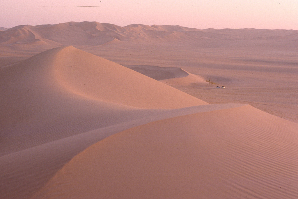
Chinook winds, also called Foehn winds, develop when air is forced up over a mountain range. This takes place, for example, when the westerly winds bring air from the Pacific Ocean over the Sierra Nevada Mountains and the Cascade range. As the relatively warm, moist air rises over the windward side of the mountains, it cools and contracts. If the air is humid, it may form clouds and drop rain or snow. When the air sinks on the leeward side of the mountains, it forms a high pressure zone. The windward side of a mountain range is the side that receives the wind; the leeward side is the side where air sinks. The descending air warms and creates strong, dry winds. Chinook winds can raise temperatures more than 20°C (36°F) in an hour and they rapidly decrease humidity. Snow on the leeward side of the mountain disappears quickly. If precipitation falls as the air rises over the mountains, the air will be dry as it sinks on the leeward size. This dry, sinking air causes a rainshadow effect, which creates many of the world’s deserts.
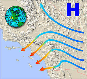
SANTA ANA WINDS
Santa Ana winds are created in the late fall and winter when the Great Basin east of the Sierra Nevada cools, creating a high pressure zone. The high pressure forces winds downhill and in a clockwise direction (because of Coriolis). The air pressure rises, so temperature rises and humidity falls. The winds blow across the Southwestern deserts and then race downhill and westward toward the ocean. Air is forced through canyons cutting the San Gabriel and San Bernardino mountains. The Santa Ana winds often arrive at the end of California’s long summer drought season. The hot, dry winds dry out the landscape even more. If a fire starts, it can spread quickly, causing large-scale devastation.
Santa Anna Winds from the desert to the coast.
Santa Anna winds blow smoke and dust from inland to the ocean.
DESERT WINDS
High summer temperatures on the desert create high winds, which are often associated with monsoon storms. Desert winds pick up dust because there is not as much vegetation to hold down the dirt and sand. A haboob forms in the downdrafts on the front of a thunderstorm. Dust devils, also called whirlwinds, form as the ground becomes so hot that the air above it heats and rises. Air flows into the low pressure and begins to spin. Dust devils are small and short-lived but they may cause damage. On July 5, 2011 Phoenix, Arizona experienced a large-scale haboob that was captured by many people using their smartphones and cameras.
A haboob in Texas.
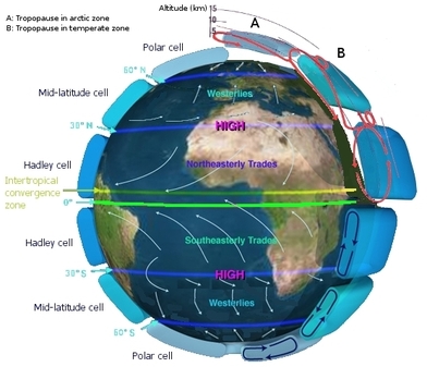
GLOBAL ATMOSPHERIC CIRCULATION
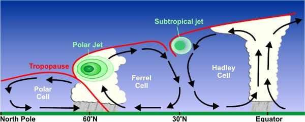
Because more solar energy hits the equator, the air warms and forms a low pressure zone. At the top of the troposphere, half of the air moves toward the North Pole and half toward the South Pole. As it moves along the top of the troposphere, it cools. The air cools, becomes more dense and begins to sink which creates a high pressure zone where it hits the ground. At the ground air spreads outwards from a high pressure center. Some air moves back toward the low pressure at the equator. This describes the convection cells immediately north and south of the equator. If the Earth did not rotate, there would probably be one convection cell in the northern hemisphere and one in the southern with air rising at the equator and sinking only at each pole. But because the planet does rotate, the situation is more complicated. The planet’s rotation means that the Coriolis Effect must be taken into account.
Let’s look at atmospheric circulation in the Northern Hemisphere as a result of the Coriolis Effect. Air rises at the equator, but as it moves toward the pole at the top of the troposphere, it deflects to the right. (Remember that it just appears to deflect to the right because the ground beneath it is moving.) At about 30°N latitude, the air from the equator meets air flowing toward the equator from the higher latitudes. This air is cool because it has come from higher latitudes. Both batches of air descend, creating the subtropical high pressure zone. Once on the ground, the air returns to the equator, from both the northern and southern hemispheres. Again, the Coriolis effect shifts the apparent direction creating the northeast trades in the northern hemisphere and the southeast trades in the southern hemisphere. These two trade converge near the equator, but equator isn’t an atmospheric phenomenon. The trade wind truly converge at the Intertropical Convergence Zone (ITCZ). The ITCZ shifts north slightly during the northern summer and south during the southern summer. The convection cell including the two subtropical highs, the ITCZ and the trade winds, is called the Hadley Cell and is found roughly between 0° and 30°N.
There are two more convection cells in each hemisphere. The Ferrell cell is between 30°N and 60°N (and S). This cell shares its southern, descending high pressure region with the Hadley cell on the equator side of the cell. Its rising region is the subpolar low, shared with the Polar cell located about 60°N (and S) and the poles, where cold air descends at the polar high. In the southern hemisphere, the Coriolis effect makes objects appear to deflect to the left instead of right. Ultimately, because there are three large-scale convection cells in the northern hemisphere and are repeated in the southern hemisphere, the model to understand these patterns is called the three-cell model.
The Three-cell Global Atmospheric Circulation Model
GLOBAL WIND PATTERNS
Global winds blow in belts encircling the planet. The global wind belts are enormous and the winds are relatively steady. These winds are the result of air movement at the bottom of the major atmospheric circulation cells, where the air moves horizontally from high to low pressure. Technology today allows anyone to see global wind patterns in real-time, such as Earth Wind Map. Take a look at the Earth Wind Map and determine what patterns you can see occurring in the atmosphere in real-time. Are low pressure systems rotating counter-clockwise in the Northern Hemisphere? Are high pressure systems rotating clockwise in the Northern Hemisphere? Can you see the global wind patterns over the Atlantic and Pacific Oceans? Also notice how the winds flow faster over water than over continents because of land friction. Let’s look at the global wind belts in the Northern Hemisphere. In the Hadley cell air should move north to south, but it is deflected to the right by Coriolis. So the air blows from northeast to the southwest. This belt is the trade winds, so called because at the time of sailing ships they were good for trade.
Surface winds and convection cells.
In the Ferrel cell air should move south to north, but the winds actually blow from the southwest. This belt is the westerly winds or westerlies. Why do you think a flight across the United States from San Francisco to New York City takes less time than the reverse trip?
Finally, in the Polar cell, the winds travel from the northeast and are called the polar easterlies The wind belts are named for the directions from which the winds come. The westerly winds, for example, blow from west to east. These names hold for the winds in the wind belts of the Southern Hemisphere as well.
GLOBAL WINDS AND PRECIPITATION
Besides their effect on the global wind belts, the high and low pressure areas created by the six atmospheric circulation cells determine in a general way the amount of precipitation a region receives. In low pressure regions, where air is rising, rain is common. In high pressure areas, the sinking air causes evaporation and the region is usually dry. More specific climate effects will be described in the chapter about climate.
THE POLAR FRONT AND JET STREAMS
The polar front is the junction between the Ferrell and Polar cells. At this low pressure zone, relatively warm, moist air of the Ferrell Cell runs into relatively cold, dry air of the Polar cell. The weather where these two meet is extremely variable, typical of much of North America and Europe.
The polar jet stream is found high up in the atmosphere where the two cells come together. A jet stream is a fast-flowing river of air at the boundary between the troposphere and the stratosphere. Jet streams form where there is a large temperature difference between two air masses.
This explains why the polar jet stream is the world’s most powerful. Jet streams move seasonally just as the angle of the sun in the sky migrates north and south. The polar jet stream, known as “the jet stream,” moves south in the winter and north in the summer.
Three Circulation Cells and the associated jet streams.

 As elevation increases, the number of molecules decreases and the density of air therefore is less, which means there is a decrease in air pressure. In fact, while the atmosphere extends hundreds of miles up, one half of the air molecules in the atmosphere are contained within the first 18,000 feet (5.6 km). This decrease in pressure with height makes it very hard to compare the air pressure at ground level from one location to another, especially when the elevations of each site differ. Therefore, to give meaning to the pressure values observed at each station, we convert the station air pressures reading to a value with a common denominator.
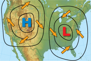


 Monsoon