6 Oceans and the Atmosphere
The goals and objectives of this chapter are to:
- Describe the significance of the ocean and how it influences weather and climate.
- Explain the different layers of the ocean.
- Understand the basic physics of ocean waves.
- Compare and contrast the differences between surface and deep ocean currents.
Environmental Questions
- Based on scientific data, some scientists have hypothesized that if enough ice from Greenland melts, the Gulf Stream might be shut down. The logic is that too much fresh water could flow into the ocean, changing the salt water it would disrupt the salt and fresh water distribution. Why might this happen and how could it influence places like Europe?
SIGNIFICANCE OF THE OCEANS
The oceans make up 70 percent of the planet and contains 97 percent of all the water on Earth. It also makes up the vast majority of water stores the majority of the planet’s moisture, terrestrial energy, and heat from the Sun. This energy is transferred between the equator and the two poles by larger surface currents by winds and deep ocean currents driven by differences in ocean density. It also provides the moisture and energy for storm systems and ultimately global climates. Phytoplankton, microscopic plants and animals in the oceans provide the foundation of the global food web of species. The earth’s oceans are so vital for life that over 40 percent of the world’s population live near coastal areas.

MODERATE CLIMATES
As terrestrial creatures, humans think of the importance of the planet’s land surfaces, yet Earth is a planet consisting of 70 percent water. From space, the dominance of water is obvious because most of it is stored in Earth’s oceans. Earth would not be the same planet without its oceans. The oceans, along with the atmosphere, keep Earth’s surface temperatures fairly constant worldwide. Some places on Earth reach as cold as -7 °Celsius, whereas other places reach as hot as 55 °Celsius. Yet on other planets like Mercury, temperatures range from -180 °Celsius to 430 °Celsius. The oceans, along with the atmosphere, distribute heat around the planet. The oceans absorb heat near the equator and then transport that solar energy to polar regions. The oceans also moderate climate within a region. At the same latitude, the temperature range is smaller along coastal areas compared to areas farther inland. Along coastal areas, summer temperatures are not as hot, and winter temperatures are not as cold, because water takes a long time to heat up or cool down.
AIR-OCEAN ENERGY EXCHANGE

The oceans are an important source of energy and mass in the atmosphere. As ocean water evaporates, shortwave energy from the sun (Qsw) is converted to latent heat of evaporation (Qlat). So humidity in the air is moving energy from its source over the ocean and into the air. That humid air mass then moves eventually over land where some water vapor may condense, releasing latent heat into the surroundings and warming the air temperature. Latent heat of evaporation cools the origin region as Qsw evaporates water rather than raising atmospheric temperature as Qsen. When water vapor condenses, it releases heat energy into the surrounding air mass and warms that region.
OCEAN MORPHOLOGY
Morphology refers to studying the shape and form of something. Of greatest interest here is the shape of the deep ocean basins and the continental margins.
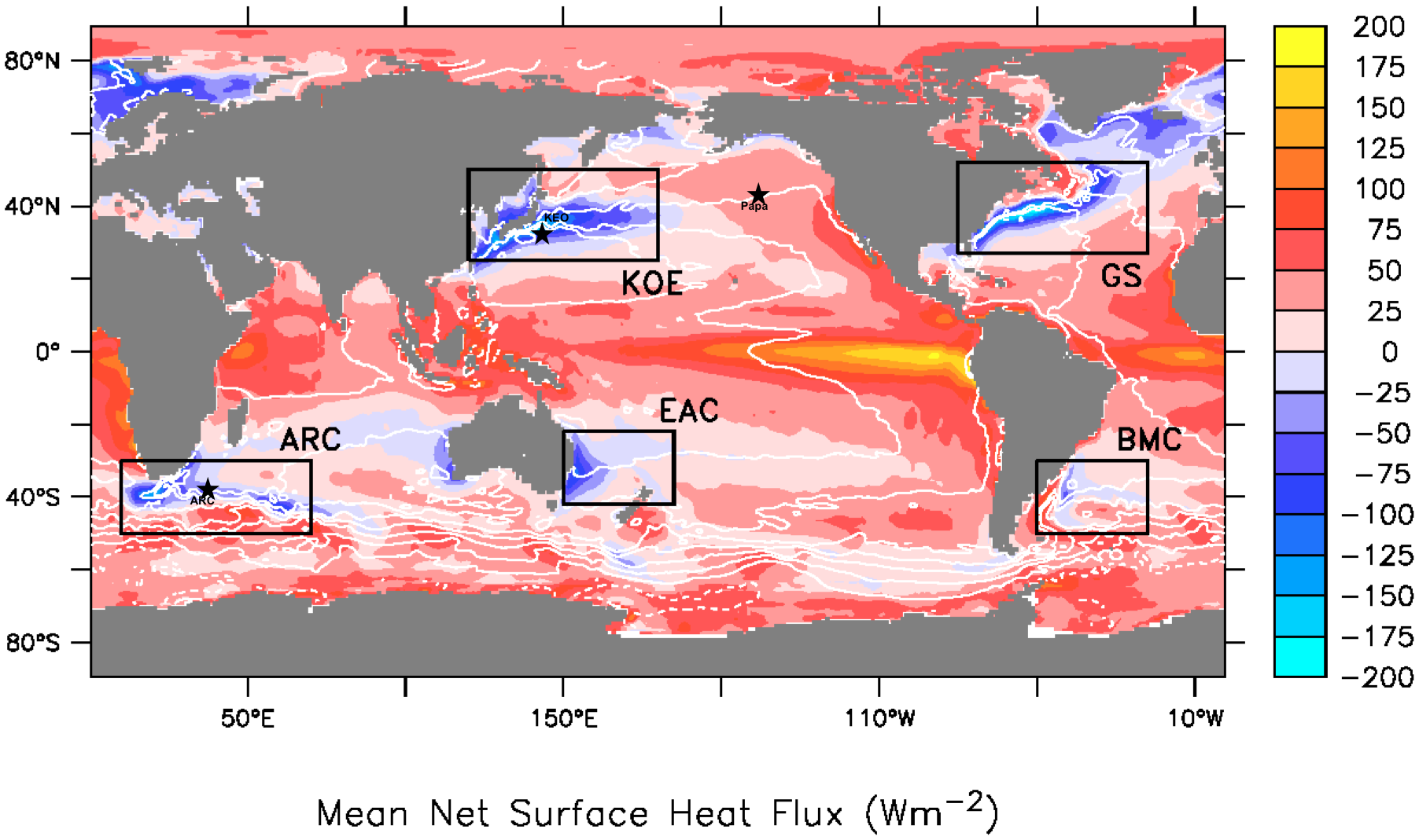
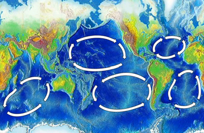
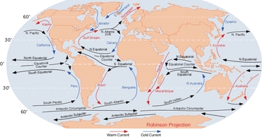
When a surface current collides with land, the current must change direction. In the figure below, the Atlantic South Equatorial Current travels westward along the equator until it reaches South America. Near Brazil, some of it goes north and some goes south. Because of Coriolis effect, the water goes right in the Northern Hemisphere and left in the Southern Hemisphere. You can see on the map below the major surface ocean currents that the surface ocean currents create loops called gyres. The Antarctic Circumpolar Current is unique because it travels uninhibited around the globe. Why is it the only current to go all the way around?
CONTINENTAL MARGIN
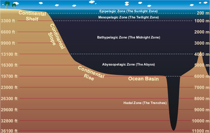
 Recall from the chapter on Plate Tectonics that the ocean floor is not flat. Mid-ocean ridges, deep sea trenches, and other features all rise sharply above or plunge deeply below the abyssal plains. In fact, Earth’s tallest mountain is Mauna Kea volcano, which rises 10,203 m (33,476 ft.) from the Pacific Ocean floor to become one of the volcanic mountains of Hawaii. The deepest canyon is also on the ocean floor, the Challenger Deep in the Marianas Trench, 10,916 m (35,814 ft). The mapping of the ocean floor and coastal margins is called bathymetry. The continental margin is the transition from the land to the deep sea or, geologically speaking, from continental crust to oceanic crust. More than one-quarter of the ocean basin is continental margin.
COMPOSITION OF OCEAN WATER

Water is a polar molecule so it can dissolve many substances such as salts, sugars, acids, bases, and organic molecules. Where does the salt in seawater come from? As water moves through rock and soil on land it picks up ions. This is the flip side of weathering. Salts comprise about 3.5 percent of the mass of ocean water, but the salt content or salinity is different in different locations. In places like estuaries, seawater mixes with fresh water, causing salinity to be much lower than average. Where there is lots of evaporation but little circulation of water, salinity can be much higher. The Dead Sea has 30 percent salinity – nearly nine times the average salinity of ocean water. It is called the Dead Sea because nearly nothing can survive within it because of its salinity. Earthquide has an interactive ocean maps, which can show salinity, temperature, nutrients, and other characteristics. Differences in water density are responsible for deep ocean currents. With so many dissolved substances mixed in seawater, what is the density (mass per volume) of seawater relative to fresh water? Water density increases as: salinity increases; temperature decreases; pressure increases.
The salinity of ocean water depending on the location. In general, salinity increases as you move away from continents and into the center of subtropical high pressure zones.

Layers of the Ocean
VERTICAL DIVISIONS
To better understand regions of the ocean, scientists define the water column by depth. They divide the entire ocean into two zones vertically, based on light level. Large lakes are divided into similar regions. Sunlight only penetrates the sea surface to a depth of about 200 m, creating the photic zone (consisting of the Sunlight Zone and Twilight Zone). Organisms that photosynthesize depend on sunlight for food and so are restricted to the photic zone. Since tiny photosynthetic organisms, known as phytoplankton, supply nearly all of the energy and nutrients to the rest of the marine food web, most other marine organisms live in or at least visit the photic zone. In the aphotic zone (consisting of the Midnight Zone and the Abyss) there is not enough light for photosynthesis. The aphotic zone makes up the majority of the ocean, but has a relatively small amount of its life, both in diversity of type and in numbers.
HORIZONTAL DIVISIONS
The seabed is also divided into the zones described above, but the ocean itself is also divided horizontally by distance from the shore. Nearest to the shore lies the intertidal zone, the region between the high and low tidal marks. This hallmark of the intertidal is change, where water is in constant motions from ocean waves, tides, and currents. The land is sometimes under water and sometimes is exposed. The neritic zone is from low tide mark and slopes gradually downward to the edge of the seaward side of the continental shelf. Some sunlight penetrates to the seabed here. The oceanic zone is the entire rest of the ocean from the bottom edge of the neritic zone, where sunlight does not reach the bottom.
OCEAN MOVEMENT
Waves
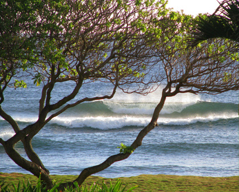
Ocean water is constantly in motion: north-south, east-west, alongshore, and vertically. Seawater motions are the result of waves, tides, and currents. Ocean movements are the consequence of many separate factors: wind, tides, Coriolis effect, water density differences, and the shape of the ocean basins. Waves have been discussed in previous chapters in several contexts: seismic waves traveling through the planet, sound waves traveling through seawater, and ocean waves eroding beaches. Waves transfer energy and the size of a wave and the distance it travels depends on the amount of energy that it carries.
WIND WAVES
Ocean waves originate from steady winds or high storm winds over the water. Sometimes these winds are far from where the ocean waves are seen. The largest wind waves form when the wind is very strong, blows steadily for a long time, and blows over a long distance. The wind could be strong, but if it gusts for just a short time, large waves won’t form. Wind blowing across the water transfers energy to that water. The energy first creates tiny ripples that create an uneven surface for the wind to catch so that it may create larger waves. These waves travel across the ocean out of the area where the wind is blowing.
A wave is a transfer of energy. Water molecules in waves make circles or ellipses. Energy transfers between molecules but the molecules themselves mostly bob up and down in place. The Internet has a variety of animations to help explain the concept of wave action. In this animation, a water bottle bobs in place like a water molecule. An animation of motion in wind waves from the Scripps Institution of Oceanography. Here is an animation of a deep water wave is seen here. Notice the circular motion of water as wave energy transfers through it. Compare that to the wave action in shallow waters using this animation.
Ocean Currents
Ocean currents are described as either surface currents or as deep ocean currents. The two types of currents are influenced by different forces.
SURFACE OCEAN CURRENTS
Surface ocean currents are currents in the upper few hundred meters of the ocean. Recall the average depth of the ocean is 12,000m so these surface waters are a small part of the overall volume, but the surface of the ocean is where there’s interaction with the atmosphere thus leading to weather and climate interaction. Surface water moves in predictable ways for thousands of kilometers. These surface currents do not depend on weather; they remain unchanged even in large storms because they depend on factors that do not change. Surface currents are created by three things: global wind patterns, the rotation of the Earth, and the shape of the ocean basins.
Surface currents are extremely important because they distribute heat around the planet and are a major factor influencing climate around the globe.
GLOBAL WIND CURRENTS
Winds on Earth are either global or local. Global winds blow in the same directions all the time and are related to the unequal heating of Earth by the Sun, that is that more solar radiation strikes the equator than the polar regions, and the rotation of the Earth called the Coriolis effect. The causes of the global wind patterns are described in detail the section about atmosphere. Water in the surface currents is pushed in the direction of the major wind belts:
- trade winds: east to west between the equator and 30° North and 30° South
- westerlies: west to east in the middle latitudes
- polar easterlies: east to west between 50° and 60° north and south of the equator and the north and south pole
ROTATION OF THE EARTH
Wind is not the only factor that affects ocean currents. The Coriolis effect describes how Earth’s rotation steers winds and surface ocean currents. The Coriolis effect causes freely moving objects to appear to move to the right in the Northern Hemisphere and to the left in the Southern Hemisphere. The objects themselves are actually moving straight, but the Earth is rotating beneath them, so they seem to bend or curve.
An example might make the Coriolis effect easier to visualize. If an airplane flies 500 miles due north, it will not arrive at the city that was due north of it when it began its journey. Over the time it takes for the airplane to fly 500 miles, that city moved, along with the Earth it sits on. The airplane will therefore arrive at a city to the west of the original city (in the Northern Hemisphere), unless the pilot has compensated for the change. So to reach his intended destination, the pilot must also veer right while flying north. Surface ocean currents in the northern hemisphere tend to rotate clockwise and in the southern hemisphere will rotate counterclockwise around the subtropical high pressure center.
As wind or an ocean current moves, the Earth spins underneath it. As a result, an object moving north or south along the Earth will appear to move in a curve, instead of in a straight line. Wind or water that travels toward the poles from the equator is deflected to the east, while wind or water that travels toward the equator from the poles gets bent to the west. The Coriolis effect bends the direction of surface currents to the right in the Northern Hemisphere and left in the Southern Hemisphere.
Local and Surface Currents
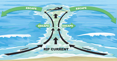
The surface currents described above are all large and unchanging. Local surface currents are also found along shorelines. Two are long shore currents and rip currents. Rip currents are potentially dangerous currents that carry large amounts of water offshore quickly. Look at the rip-current animation to determine what to do if you are caught in a rip current. Each summer in the United States at least a few people die when they are caught in rip currents.
Surface currents play an enormous role in Earth’s climate. Even though the equator and poles have very different climates, these regions would have more extremely different climates if ocean currents did not transfer heat from the equatorial regions to the higher latitudes.
The Gulf Stream is a river of warm water in the Atlantic Ocean, about 160 kilometers wide and about a kilometer deep. Water that enters the Gulf Stream is heated as it travels along the equator. The warm water then flows up the east coast of North America and across the Atlantic Ocean to Europe. The energy the Gulf Stream transfers is enormous: more than 100 times the world’s energy demand.
The Gulf Stream’s warm waters raise temperatures in the North Sea, which raises the air temperatures over land between 3 to 6 °C (5 to 11°F). London, U.K., for example, is at the same latitude as Quebec, Canada. However, London’s average January temperature is 3.8 °C (38 °F), while Quebec’s is only -12 °C (10 °F). Because air traveling over the warm water in the Gulf Stream picks up a lot of water, London gets a lot of rain. In contrast, Quebec is much drier and receives its precipitation as snow.
Deep Currents
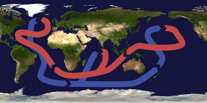
Thermohaline circulation drives deep ocean circulation. Thermo means heat and haline refers to salinity. Differences in temperature and in salinity change the density of seawater. So thermohaline circulation is the result of density differences in water masses because of their different temperature and salinity. What is the temperature and salinity of very dense water? Lower temperature and higher salinity yield the densest water. When a volume of water is cooled, the molecules move less vigorously so same number of molecules takes up less space and the water is denser. If salt is added to a volume of water, there are more molecules in the same volume so the water is denser.
Changes in temperature and salinity of seawater take place at the surface. Water becomes dense near the poles. Cold polar air cools the water and lowers its temperature, increasing its salinity. Fresh water freezes out of seawater to become sea ice, which also increases the salinity of the remaining water. This very cold, very saline water is very dense and sinks. This sinking is called downwelling. A significant amount of downwelling occurs north of Scandinavia. The North Atlantic Drift moves through the large gap between Greenland and Scandinavia. This gap allows more water to move into the Arctic Ocean from the Atlantic Ocean, then c. There is a much smaller gap in the Bering Strait so relatively little water moves from the north Pacific Ocean into the Arctic Ocean.
Two things then happen. The dense water pushes deeper water out of its way and that water moves along the bottom of the ocean. This deep water mixes with less dense water as it flows. Surface currents move water into the space vacated at the surface where the dense water sank. Water also sinks into the deep ocean off of Antarctica. Since unlimited amounts of water cannot sink to the bottom of the ocean, water must rise from the deep ocean to the surface somewhere. This process is called upwelling.
Generally, upwelling occurs along the coast when wind blows water strongly away from the shore. This leaves a void that is filled by deep water that rises to the surface. Upwelling is extremely important where it occurs. During its time on the bottom, the cold deep water has collected nutrients that have fallen down through the water column. Upwelling brings those nutrients to the surface. Those nutrient support the growth of plankton and form the base of a rich ecosystem. California, South America, South Africa, and the Arabian Sea all benefit from offshore upwelling.
Upwelling also takes place along the equator between the North and South Equatorial Currents. Winds blow the surface water north and south of the equator so deep water undergoes upwelling. The nutrients rise to the surface and support a great deal of life in the equatorial oceans.
ENSO (El Niño Southern Oscillation)

To a great extent, warm, buoyant water stays near the upper 200m of the ocean. Winds and the Coriolis effect drive surface ocean currents, but thermohaline circulation drives deep ocean circulation. Where the warm surface water meet the cooler deep water, there is a rapid change in temperature over a short change in depth. This is a thermocline.
In the Pacific Ocean, Equatorial Easterly winds blow consistently from east to wind from Peru toward Australia. This pushes the warm surface water towards Australia and allows the cooler, deeper waters to rise to the surface near Peru. A wedge of warm water gets progressively deeper as you near Australia. This is the normal, expected situation that happens most of the time. This is called La Nada. However, once in a while, perhaps every 7-12 years, the easterly winds slow down and the warm water extends all the way to the Peruvian coast. This event leads to more rain in Peru and the water warm forces cool-water fish to move away. This happens around Christmas and is called an El Niño. In contrast, if the easterly winds are stronger than usual, the warm water wedge extend a shorter distance from Australia and the cool water extends farther from Peru. This is a La Niña.

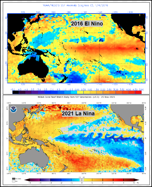
Since these events are constantly shifting between the extremes of El Niño and La Niña in the southern Pacific, the phenomenon is called the El Niño Southern Oscillation, or ENSO. It is not well understood what creates the shift from one extreme to the other, but we are able to predict a few months in advance what situation to expect. This prediction is based on monitoring sea surface temperatures and comparing existing conditions with the long term average temperatures.
The impact El Nino events has been recorded for hundreds of years in western South America. The concern is the recurrence interval is shortening to a 5-7 year cycle over the last several decades. In the figure of the Multivariate ENSO Index, red peaks are El Nino events, blue are La Nina. The 0.0 horizontal line is a long term average situation. 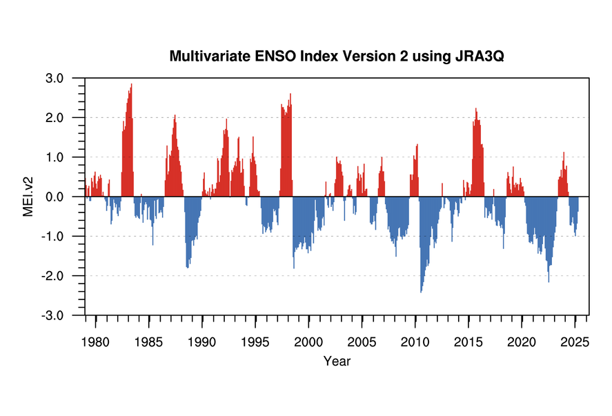
In 2023 there was a shift from a long La Nina period to a noticeable El Nino.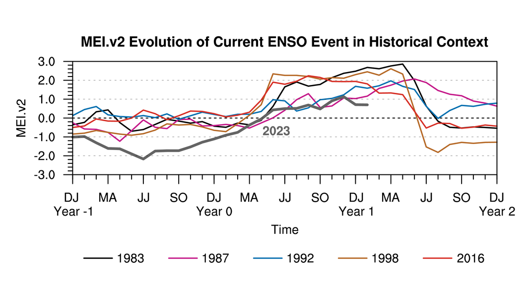
Links to more information
Click here to view the present ENSO situation.
