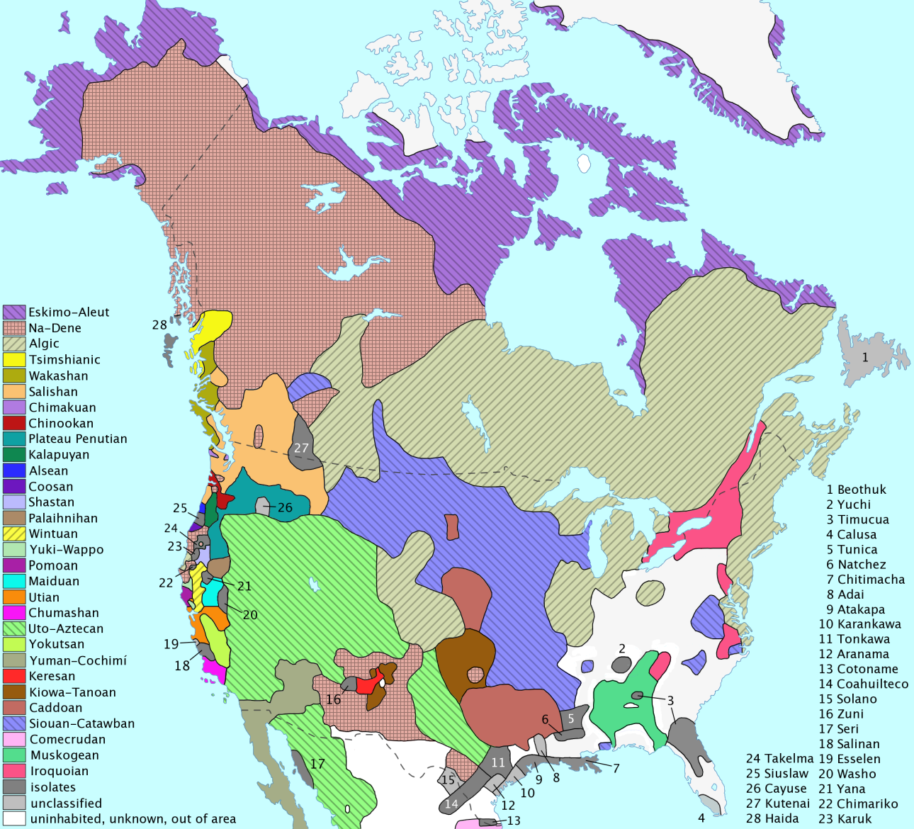
18 The Americas and Oceania
Mieko Matsumoto and Eugene Berger
INTRODUCTION
DISCOVERY — Writing in the Americas and Pacific
The indigenous peoples who populated the Americas and Moananuiākea (the vast Pacific) prior to European contact were incredibly diverse. Their material artifacts, oral and written records, and cultural traditions are testament to the sophistication of their political systems, the extent of their prosperity, and their varied religious and scholarly traditions. Some (but not all) of the indigenous communities of these regions utilized oral traditions to create, preserve, and transmit knowledge between generations. Others, including the Olmec, Maya, and Aztec developed writing systems. Unfortunately, the dramatic cultural and political changes (in concert with disastrous demographic decline due to introduced disease) that accompanied European and U.S. colonization disrupted both oral and written traditions across the Americas and Moananuiākea. Additionally, in the Americas, colonization was accompanied by outright intentional violence as Europeans sought to establish their claim to land and resources. As a result, scholarly understandings of these cultures and societies prior to contact with the Western world is limited. Additionally, it is important to recognize that much of the records and scholarship, generally composed by European or White American authors, created after colonization were biased by their often ethnocentric worldviews.
In the case of Hawaiʻi, prior to the arrival of Westerners, knowledge was transmitted through “a disciplined pedagogy of listening, retaining, and repetition” (Malo 2020, 23). Individuals were chosen at a young age to undergo rigorous training directed and overseen by kāhuna (experts in a variety of fields) and kūpuna (elders). Scholar Noelani Arista writes that during this time Kānaka (people of Hawaiian ancestry) understood “the authoritative speech of akua (gods), ʻaumākua (gods belonging to particular lineages), aliʻi (chiefs), kāhuna (priestly experts or experts in other schools of knowledge, and kāula (seers) [to be] indices of ancestral knowledge” (Malo 2020, 23). However, the arrival of increasing numbers of Westerners after the 1820s ushered in a period of rapid cultural change, accompanied by the introduction and spread of Christianity. To best facilitate the conversion of Kānaka, Protestant missionaries labored to develop ka pīʻāpā Hawaiʻi, an ʻōlelo Hawaiʻi alphabet based on the English alphabet. Many Kānaka were eager to develop literacy in not only ʻōlelo Hawaiʻi, but also English which had great utility in trading spheres. As a result, by the end of the 1830s literacy rates for Kānaka Maoli reached nearly 95% with many Kānaka Maoli achieving bilingualism.
Kānaka were not only prolific readers, but also writers and filled the pages of ʻōlelo Hawaiʻi newspapers with accounts of contemporary events, retellings of moʻolelo (historial account; history, literature, narrative), and mele (song). The moʻolelo include mele koʻihonua (cosmogonic genealogies) that “run the gamut thematically from evolution, birth of islands via the mating of gods, and volcanic eruptions to biblically influenced stories” (Oliveira 2014, 1). Thus, a vast array of accounts in Kānaka voice exist today. This rich repository of knowledge offers insight into the Kānaka past, however, any reading and use of these writings must be done with care. Take for instance, Ka Moʻolelo Hawaiʻi, a 19th century text that recounts, in great detail, Hawaiian culture and lifestyles prior to the 1820s. The author, Davida Malo, was the recipient of years of traditional Hawaiian training in addition to a Christian education. Scholars Charles Langlas and Jeffrey Lyon write that only 3 (of which Malo is one) early Kānaka writers were able to provide accounts of Hawaiian culture before it was greatly impacted by Western influence; the others were Kēlou Kamakau and John Papa ʻĪʻī. Later authors “who were not eyewitnesses of that culture, did often syncretize” Hawaiian culture and beliefs with Western ones, like Christianity (Malo 2020, 9). Maloʻs work, Ka Moʻolelo Hawaiʻi, was published only after his death and early publications were English translations. The most widely used version of Maloʻs work is the English translation by Nathaniel Emerson (published in 1903 and again in 1951). This publication did not include the original Hawaiian text. Later scholars have emphasized the limitations of this translation, noting that Emerson often omitted aspects of Maloʻs work or inserted his own information. A number of other limitations exist, including but not limited to: Emersonʻs ethnocentric bias, unclear endnotes, disparities between early 19th century Hawaiian language and modern Hawaiian language conventions, and lack of clear and direct English equivalent of particular Hawaiian words, sayings, and grammatical patterns. Further, in her essay “Davida Malo, a Hawaiian Life” Noelani Arista demonstrates that “historicizing the importance of speech, writing, and literacy” during David Maloʻs life can serve as a lens through which one can analyze the dramatic political, social, and economic changes of the 1800s. Doing so reveals the ways in which Hawaiian scholars like Malo deployed their knowledge “in the service of Hawaiian governance, in the preservation of Hawaiian social relations, and that, during [the tumult of the 1800s] were applied to promoting education and the new religion, Christianity” (Malo 2020, 25). Thus, use of primary sources must always be done with care and attention to the author as an active participant in the production of knowledge, not just the transmission of it.
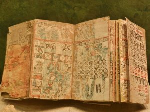
While the mentioned Kānaka writers (Davida Malo,Kēlou Kamakau and John Papa ʻĪʻī) produced written records that relate traditional lifestyles prior to Western contact and still survive today, records that may have conveyed traditional religions, politics, and culture in the Americas were largely destroyed in the years following European arrival on the continent. The Maya produced detailed records, codices, that were copied and bound into books made of bark paper. These codices probably dated to the 1100s and likely recorded a vast and more varied range of information than that found in stone inscriptions and on pottery. In his 16th century records, Alonso de Zorita remembered seeing codices that “recorded their history for more than eight hundred years back, and which were interpreted for me by very ancient Indians” (History of Maya Codices). However, during the 16th century Franciscan missionaries ordered the burning of the codices in order to undermine traditional religious beliefs and promote conversion to Christianity. Of the many codices that once existed, only 4 remain (3 complete and 1 fragment). In addition to the codices, scholars interested in excavating the Maya religion can turn to the Popul Vuh. The Popul Vuh is believed to have been written by a Mayan author or authors in the 16th century in a Mayan language using Latin script. In the 18th century the Popul Vuh was copied by a Spanish priest and translated to Spanish. The original text has been lost. Thus, while there are written records composed by indigenous Americans, limitations related to translation exist. For example, prior to the arrival of Europeans, the Maya used over 800 glyphs in their writing, the meaning of which were lost after Spanish arrival and the subsequent replacement of the glyphs with Latin script. It took scholars decades to decipher the glyphs and today the majority are known.
After European arrival in the Americans, Spanish, French, English and Dutch settlers recorded copious amounts of records of their experiences. However, their biases and agendas, often linked to economic gain and/or religious proselytization), their accounts of indigenous culture and practices. Undoubtedly the most misunderstood practice in the Americas was that of human sacrifice, witnessed by the Spanish conquerors of the Aztec Empire. Among Mesoamerican and Andean peoples alike there was a belief that all life, cosmic, human, animal, and plant alike, grew beneath the soil and sprung forth above the surface. Furthermore, humans had a role in nurturing that life cycle. In many of the indigenous cultures we will discuss, shamanism was an important religious tradition; shamans or religious specialists could control the forces of the natural world. Often shamans would conduct ceremonies requiring sacrifices from members of the community to ensure cosmic and earthly order. While the Spanish (and Hollywood) tend to focus on more dramatic ceremonies where hearts are cut from living warriors, other kinds of sacrifices in Mesoamerica and the Andes were integrated in hundreds of ways into daily life. For many cultures ritual bloodletting was a widespread practice, but one where the injured party survived to perform the ceremony the next year. Oftentimes, human-shaped grain cakes would serve as stand-ins for actual human participants. Most sacrifices in fact were actually offerings or prayers to Mesoamerican or Andean deities. For example a Nahua newborn might be named in honor of Maya rulers. Or the first corn tortilla of the day might be consumed in honor of the sun (Read and Gonzales 2000, 25-26). These beliefs would eventually be manifest in physical structures like a cave under Teotihuacán’s Pyramid of the Sun in Mexico or sunken plazas at Chavín de Huantar in Peru and Tiwanaku in Bolivia. These sacred spaces were constructed beneath the earth’s surface to allow the cultures aboveground easier access to the Earth’s creative capacity. These types of cultural nuances can easily be overlooked or misunderstood when historical analyses do not take into consideration bias (personal and also historical) and the impacts of colonization on indigenous record keeping.
Learning in Action – Maya Record Keeping
Read: “Ancient or Fake? The Mystery of a Maya Book”, Emilia Sánchez González, Getty, October 27, 2022
Link: https://www.getty.edu/news/ancient-or-fake-the-mystery-of-a-maya-book/
Watch the video: “Making Amate Paper”, Getty Museum. 2023. Turn on closed captioning for English subtitles.
Link: https://www.youtube.com/watch?v=OF8eZTo9WB4
OVERVIEW
This chapter addresses the early cultures of the Americas and Moananuiākea. These regions were characterized by incredible cultural and linguistic diversity. Thus this chapter is only able to provide a snapshot of some of the cultures found in these areas. This chapter begins with an overview of Mesoamerica and then travels northward to North America. Finally, we gaze across the Pacific to review human migration and settlement patterns across the vast ocean. Historians today recognize that the idea of the Pacific, as a bounded area, is a construct. Author John Ryan Fischer notes “European explorers and cartographers, on behalf of their empires, mapped a vast body of water, and, as they sought to understand, conquer and profit from it, they created the concept of the Pacific Ocean” (Fischer 2015, 5). In doing so, European empires (and later the U.S. empire) not only renamed spaces, they reconceptualized them. In recognizing the importance of indigenous ways of knowing and the ties between the authors of this remixed textbook and Hawaiʻi, the area commonly referred to as the Pacific Ocean will be referred to as Moananuiākea, “the vast Pacific” (Kaʻiwakīloumoku). Emphasis will be placed on voyaging and early settlement throughout Moananuiākea with greater detail provided to the history of early Hawaiʻi.
THE AMERICAS: MESOAMERICA
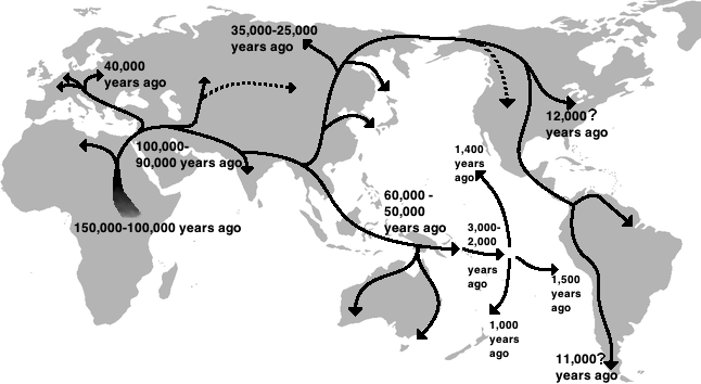
Early American cultures developed according to patterns similar to civilizations in other parts of the world. The progression from hunting/gathering to agriculture, from farming villages to cities, seems to have occurred in the same basic sequence, though the agricultural crops and domestic animals involved were different. The significant differences between pre-Columbian American societies and cultures emerging in the rest of the world reflect the fact that the American continent was not settled by humans until between 40,000 and 20,000 years ago. The ancestors of Native Americans seem to have migrated to the Americas across the land bridge that existed between Siberia and Alaska at that time, what is today the Bering Strait. Humans probably migrated following herds of animals they were hunting. Waves of migrating tribes likely continued to enter the Americas thousands of years, until the land bridge disappeared under water with the ending of the last ice age, sometime between 12-8,000 BCE. From this time until the voyages of ‘discovery’ and later conquest by Europeans, all Native American societies developed in isolation from the rest of the world, resulting in some intriguing similarities and fascinating differences.
Archaeologists believe the earliest Americans gradually migrated south along the West Coast to Patagonia, then began moving back northward to eventually populate the Great Plains and the East Coast of North America. The tremendous diversity of the Americas led to development of myriad cultures and lifestyles.
Although scholars believe that Homo sapiens migrated to Beringia and hence North America first, Mesoamerica was the first section of the Americas where scholars have found evidence of large settlements, agriculture, and unique cultural traditions. The ancient Mesoamerican culture area is found in what are now the modern countries of Guatemala, Mexico, Belize, El Salvador, and eastern Honduras. The region’s frequent volcanic eruptions, earthquakes, and hurricanes gave it a staggering amount of ecological diversity including mountains, coastal plains, and a peninsular limestone platform (the Yucatán). The region’s climatic diversity is attributable to the fact that it sits in both tropical and subtropical latitudes.
Less is known about migration to Mesoamerica than for North and South America during the Paleoindian period, but many scholars put people in the region by 15,000 BCE. These early residents hunted large and small game alike and consumed a wide range of plant resources. The Archaic period in Mesoamerica stretched from 8,000 to 2,000 BCE, during which scores of cultures adapted to the region’s ecological diversity by domesticating wild food sources like “beans, squash, amaranth, peppers, and wild Maize (teosinte)” (Smith and Masson 2000, 8).
Early Farming in Mesoamerica
Just as early farmers in Southwest Asia turned wild plants into domestic crops, so too did their contemporaries in Mesoamerica with maize, squash, and tubers. Foragers in the southern Mexican highlands lived on a diverse diet of plants and animals, including cactus fruit, corn, squash, beans, fish, deer, and rabbits. Their contemporaries in the tropical lowlands further south consumed tubers like manioc, sweet potato, arrowroot as well as fruits like avocados. While Mesoamericans did domesticate most of these crops, they did so before becoming sedentary, a fact revealing the existence of regional variations in the path to agriculture. Around 10,000 years ago, Mesoamericans began to cultivate squash, both as a food source and for use as storage containers. Rather than staying near their cultivated land, however, early planters formed mobile “agricultural bands” who still roamed and hunted and would return to harvest mature squash or chilies. Over time, these bands planted more and hunted less until eventually they formed sedentary agricultural villages. But that process took at least 2,000 years. In fact, it may have been in the much denser tropics in and around Panama where residents first left foraging behind for agriculture. Around 10,000 BCE, after the extinction of megafauna hunters had relied on, these tropical peoples began to cultivate their forest environment. Tropical cultivation tended to be limited, but tropical residents did manage to domesticate the tubers like manioc, sweet potato and arrowroot that we mentioned above (Ristvet, 43-46).
Over the next several centuries, village dwellings themselves revealed a growing emphasis on permanence and increasing sophistication. Brick walls and plaster floors began to replace hides and sticks. Unlike round huts, new rectangular houses allowed for expansion by extending walls and adding a perpendicular end wall. Expanding permanent dwellings allowed villages to grow through natural population increase. Permanent dwellings also helped establish distinctions between public and private space and public and private activities, affecting communal and private property. Not only did villages have to decide where and how to build, they also had to organize around when to plant, where to settle, when to harvest, and where to store the food. The invention of pottery during this period served storage needs tremendously. Tasks in construction, gathering, defense, and food production became more specialized and supervised, leading to the beginnings of social class differentiation. A class of elite individuals developed, a strata usually comprising warriors, priests, and administrators.
The Olmec
By around 2000 BCE, most residents of Mesoamerica were sedentary, many living in small bands that moved only seasonally (Pool 2007, 6). However, by 300 CE many of these small bands had been replaced by quite common large urban centers. This was a rapid transition, to say the least. This rapidity was possible because of greater use of domesticated crops and storage and improved technology, like pottery vessels. Pottery appeared between 1,900 BCE and 1,750 BCE on the Pacific coast of Chiapas in highland valleys and on the Gulf Coast. After about 1,400 BCE, scholars start to see widespread sharing of obsidian, shell, jade, and iron artifacts, a sharing which denotes significant interaction by this point. A social hierarchy also began to develop in Chiapas, where there was a two-tiered settlement hierarchy of small centers and villages. In other words, the elite had bigger houses. Over time and in more areas, plastered floors and dirt floors appeared in different dwellings and altars in others. Burials too indicated social differentiation.
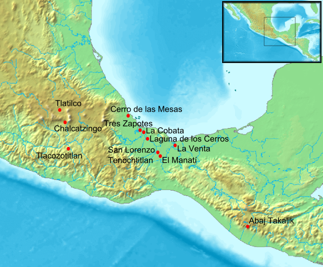
The Olmec were the earliest civilization in Mesoamerica and, therefore, drove much of this rapid development. The Olmec culture developed along the Gulf of Mexico and flourished from 1,500 BCE to 100 CE. Olmec farmers raised crops that included maize and beans. Seafood served as an important source of protein. Like many of their historical contemporaries, Olmec religion seems to have been largely influenced by their natural surroundings. Scholars believe that the Olmec worshiped gods that represented natural phenomena and animals. The Olmec also are believed to have assigned spiritual significance to various environmental features that included caves and mountains.
Although the Olmec were initially organized in tribes, they soon began to form a set of chiefdoms that allowed for organized leadership across generations,through kinship ties. Under this political centralization Olmec urban centers developed by around 1,200 BCE. These urban sites were primarily used for religious purposes but were also key in facilitating trade with other regions. Two of the major known Olmec urban centers are San Lorenzo and La Venta. San Lorenzo is the first known Olmec urban center. San Lorenzo stood at the apex of a three- or four-tiered settlement hierarchy which included subordinate centers, villages, and special purpose sites.
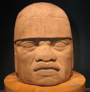
Archaeological research at both San Lorenzo and La Venta have revealed a great deal about Olmec culture. Large numbers of stone sculptures have been found at both sites, including massive carved stone monuments. Over 200 known monumental stone sculptures remain; one-third are from San Lorenzo and the surrounding area. The largest monuments are stone heads; some stand up to three and a half meters tall. Made of basalt, the largest of them weighed over forty tons. Stones had been transported as much as ninety kilometers from their sources. The labor required to do this demonstrates the power of these rulers.
Each head is unique, containing its own ear ornaments, headdress, specific facial features, and expressions. Most scholars think they are portraits. In addition to these monuments, table top altars have been found in a range of sizes across Olmec sites. Most now believe they served as thrones but others believe they served as altars as well. They often show humans emerging from a niche in front of the monument. The Olmec also crafted smaller sculptures in the round. These sculptures incorporated human and supernatural themes or humans in ritual or symbolic postures. A fourth sculptural style, one that corresponds to later years, was stelae. These stelae often depicted supernatural beings and elaborately dressed individuals engaged in specific actions. All of these stone monuments and sculptures would be impressive for modern humans to achieve but are made more impressive considering the fact that the Olmec possessed no metal tools with which to cut them.
The purpose behind these sculptures, outside of their artistic value, seems to have involved monumentality. Stone as a whole gave a sense of order, stability, and equilibrium. The sheer size of the statues would have evoked feelings of awe and grandeur in viewers. Stone sculptures also seem to have served religious purposes. For the Olmec as shamanists, a direct connection existed between order on earth and order in the spiritual world. Olmec shamans, through ritual and through the assistance of their nagual (also referred to as nagualo) or “animal spirit companions,” could travel to the supernatural world or guard against spirits who desired them harm (Reilly 2000, 374). Therefore, a number of altars and smaller sculptures show human-jaguar or human-dragon anthropomorphs, particularly those that reflect the existence of a gateway or portal between worlds. When the Olmec ruler sat on the throne he could be present in both the natural and supernatural realms. This journey between worlds was aided by the intercession of the ruler’s animal spirit companion (in this case a jaguar) (Reilly 2000, 374).
As noted, the ability to commission stone monuments and sculptures was indicative of political clout and wealth. Olmec elites further projected their status in society by erecting large homes filled with carved columns, drains, and embellishments. The elite also traded for iron and jade; objects made from both have been found in Olmec tombs and archaeological sites. In fact, thousands of tons of “serpentine blocks” have been found buried in massive offerings at the Olmec center of La Venta in southern Mexico (Pool 2007, 15).
While the Olmec are recognized as being the first to achieve political centralization and the first to develop urban centers in Mesoamerica, debate continues regarding the extent of their political power. Some scholars refer to the Olmec as an “empire,” but most say it falls short for a few important reasons. First, the Olmec never had a large enough population at their disposal to form a conquering army. Second, while there existed a number of significant urban Olmec sites, such as La Venta and San Lorenzo, questions remain as to whether either constituted a capital city. Finally, the art and archeological records of surrounding societies don’t indicate an Olmec domination but rather the existence of something of a theocratic state, as elites seemed to have both political and religious authority and a considerable amount of influence.
Final questions related to our understanding of the region are: Why did the Olmec develop complex political structures and what factors lay behind the timing of these developments? One theory involves the ecological relationship to Mesoamerica’s lowland environment. Another holds that increasing productivity led to high population growth, which caused a pressure to organize politically. Control of these resources as well as the limited use of warfare accounted largely for the authority of individual chieftains. Other scholars have added to this observation, pointing out that the abundance but lack of diversity of Olmec area agriculture forced them to develop a competitive advantage vis-à-vis societies that lived closer to obsidian, salt, and stone deposits. The Olmec would need to trade for these resources that were central for hunting and food production. A more sophisticated society would have that advantage.
The Maya
The Mayan people are thought by anthropologists to have migrated to Mesoamerica from the north sometime between 1,500 BCE and 100 CE. By 1000 CE, the city of Kaminaljuyu was thriving, and the Maya had clearly already developed their own writing and mathematical systems. Mayan beliefs clearly reflect influence from the Olmec and Teotihuacan cultures including the religious importance of Mayan pyramids and ball courts.
The influence of the Olmec on the Maya may seem superficial, but it was quite important, as the Mayans’ rise in sophisticated cultural developments was so fast and so complete that it almost defies explanation. After settling at the base of the Yucatán Peninsula around 1000 BCE, the lowland Maya learned how to deal with drought, feed tens of thousands of people, and organize politically – all before 250 BCE.
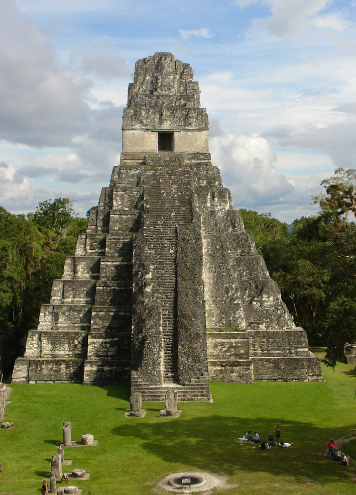
The Late Classic period was one of tremendous growth. The city of Tikal, in present day Guatemala, reached a population of 80,000 by CE 750, while the population of its rival Calakmul reached 50,000. To support these large populations, the communities of the Late Classic Maya inhabited an almost totally engineered landscape that included water management projects, flattened ridge tops, and terraced hillsides. The population was fairly dense in cities and in the surrounding countryside. Their leaders had tombs built in their honor, imported luxury items like jade statues, feathers, cacao, and other items from the Mexican Highlands.
The Late Classic Maya had an advanced numerical annotation system of dots and bars and used zero. Maya writing began as pictographs and blended into quite artistic symbolism. In addition to their more than seven hundred carved monuments, the Maya culture produced wooden carvings, incised jades, and pottery.
Politically, the Maya were never unified under one ruler or even a set of rulers. Instead, the Maya were a civilization that shared a set of cultural traits, a language family, but no single ruler or sense of common identity. Individual Maya kingdoms rose and fell, but none was ever able to dominate the entire Maya area. While their rule was perhaps not widespread, Maya rulers did hold tremendous power and prestige within their kingdoms. Rulers were kings at the top of a steep social hierarchy that was reinforced by religious beliefs. The king was a hereditary ruler chosen by the gods and a member of one of several elite bloodlines.
The Mayan religious cosmology viewed humans as a crucial part of nature based on their ability to be aware of nature and to mark time; humans thus had the duty to be nature’s timekeepers and chroniclers. Humans were nature’s consciousness, without which nothing would have meaning. It was their burden to give nature and time meaning, every day. To fulfill this duty, Mayan culture produced complex mathematics and a number of sophisticated calendars. The ritual calendar was based on 13 twenty-day months. The regular calendar was a 365-day system. These two were improved versions of calendars that had existed in Mesoamerica since the Olmec civilization. They were all created based on naked-eye observation of the skies, and were far more accurate than contemporary European, Chinese, or Muslim calendars at the time. The Maya also developed a calendar called The Long Count. This was also a very accurate calendar that kept track of the events of civilization, nature, and the heavens in a multi-million-year cycle. The Long Count was used to predict such events as eclipses, solstices, periodic comets, and other large-cycle natural events. To create such sophisticated calendars, the Maya developed a sophisticated mathematics based on the number 20. The writing system created to help maintain records was also complex, and its decipherment so difficult that it has only recently been translated.
The Maya priestly class officiated between the community and a complex pantheon of both gods and deified ancestors. This ancestor worship required not only ceremony and temple building, but a complex understanding of calendrics as well. Both the Maya and the Olmec understood time as “a set of repeating and interlocking cycles instead of the linear sequence of historical time,” much as the concept is understood today (Restall and Solari 2012). Long cycles alternated with short cycles; the long periods involved the repeated creation and destruction of the world in their sacred stories—with an emphasis on repetition. Since cycles are by definition repeated, certain dates are more important than others because they are attached to good and bad events in the past. Calendar priests determined what those dates were and so had considerable power. They also had the power to rewrite the course of events if this benefited the ruler (Restall and Solari 2012).
Despite these impressive achievements, Mayan cities collapsed long before the Europeans arrived, likely due to a combination of chronic war between Mayan city-states, overpopulation and destructive practices that degraded the natural environment on which the society depended.
Reading the Past – Maya Art
View the collection: Maya Collection, Kimbell Art Museum.
Link: https://kimbellart.org/collection?keys=maya
Take some time to look at and read the captions for 3-5 different art pieces.
Reading the Past – Popul Vuh
Read: “First Book, “Myth of Vucab-Cakix,” and “The Second Book” from the Popul Vuh, Lewis Spence, 1908.
Teotihucán and the Toltec
While the Olmec and Maya accomplished incredible things, urbanization to the north in Mexico’s central valley may have left the most permanent legacy. To the north of the Maya culture area, the Valley of Mexico was the most “agriculturally desirable” zone in Mesoamerica. Climate was temperate, and rainfall, although not abundant, was predictable – in contrast to the drenching rains of tropical Mesoamerica. Lesser amounts of rainfall of course required aqueducts, reservoirs, and canals if a city were to thrive. Cuicuilco was such a city that rose to prominence in the Valley of Mexico by 150 BCE, only to be badly damaged by a volcanic eruption around 400 CE. The subsequent decline of Cuicuilco allowed a competing city, Teotihuacán, to rise to prominence in the area, and by 100 CE, its population reached 60,000 inhabitants. By 550 CE, Teotihuacán was one of the six largest cities in the world, with a population of 125,000. Teotihuacán covered more than 20 square kilometers, had a marketplace, an administrative center and several different types of housing. Its largest buildings seem to have had both a functional and a spiritual use.
The center of Teotihuacán was a broad Avenue of the Dead which runs along a north-south axis for an impressive distance. This was the city’s ceremonial center and includes a Pyramid of the Moon aligned with the orbital paths of the moon during the era this city thrived. This site was a religious and sacrificial center. Along the length of the avenue is a kind of canal that may have carried drinking and/or cleaning water. Also found in this temple complex is the equally impressive Pyramid of the Sun which rivaled anything created in the ancient Eastern Hemisphere. It extended 275 feet on every side, with a height of over 100 feet. It sits above a tunnel and cave complex, including a pre-historic cave probably associated with important creation myths. Both the pyramids of sun and moon were set to align with their respective namesakes during specific astronomical events.

Surrounding the central plaza were homes and markets, also often built in pyramid-style buildings. The city was quite wealthy during its heyday, experiencing great success in trade. In fact, Teotihuacan was one of the wealthiest cities in the world during the 6th century CE. This network of traders helped Teotihuacán to have a major effect on the culture of surrounding groups. By the 4th century CE, Teotihuacán had the modern equivalent of neighborhoods; new houses were laid out on a rough grid with many homes organized into apartment compounds (Adams 1997, 46-49). The dwellings were constructed of volcanic rock, mortar, and wood for the roofs. The compounds also had a system of underfloor drains. Many of the dwellings in these complexes are decorated with “polychrome wall murals” containing multiple religious themes and military themes, some depicting play or everyday life, while others being much more abstract (Adams 1997, 46-49).
To support its massive population, Teotihuacán needed to secure supplies and tribute from surrounding areas. Many neighboring areas were conquered through a combination of trade and military conquest. Force was used to secure trade routes to the south and thus ensure access to goods as diverse as cacao beans, tropical bird feathers, salt, medicinal herbs, and honey. Once the city’s influence had expanded and they had become the region’s undisputed merchant power, its subsistence base increased to include the entire Basin of Mexico and some neighboring peoples like Tlazcala. The reach of Teotihuacán’s leadership even extended into Maya kingdoms like Tikal where it influenced, and may have even ousted, a Maya ruler in the late 4th century. Tikal’s position within its own region may in fact have been strengthened by this subordination to Teotihuacán (Adams 1997, 46-49).
Teotihuacán was able to sustain impressive growth and expansion for more than five centuries, but ultimately its size and complexity seemingly contributed to its decline. At about 650 CE, roughly half of Teotihuacán’s public buildings and a number of temples, pyramids, and palaces were burned. Many were knocked down and torn apart as well. This does not seem to be the work of invaders, but instead internal and external groups who attacked declining symbols of power. Much remains unknown about the peoples who lived at Teotihuacán. However, despite its demise, Teotihuacán greatly influenced the cultures and architecture of later Mesoamerican societies. In fact, its name comes from the Aztec, a Nahuatl speaking people who migrated to the region and discovered the city in the 1,400s.
The Late Classic Mayans also experienced a collapse of their cultural systems around 840 CE. Years of population growth, and demands on and from the elite, came to a head with a period of prolonged drought in the early 9th century. Resulting famines and infighting caused population losses in Maya settlements nearing eighty-five percent; in many areas abandoned farmlands were retaken by the forest (Adams 1997, 60-65).
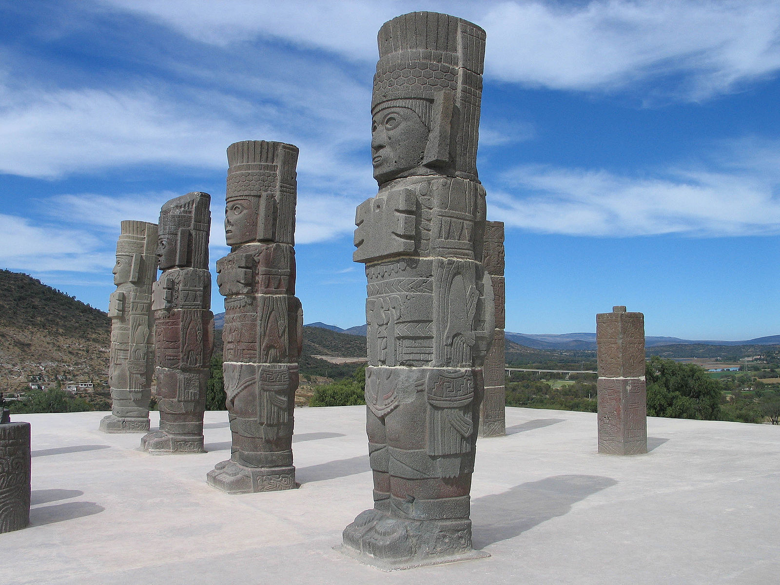
While many of these Late Classic Maya sites would never recover from their demographic decline, Mesoamerica remained fertile and southern Mexico remained temperate, so a number of polities rose to prominence in the area after the above mentioned declines. Tula, which had been founded by Teotihuacán leaders as an administrative center, emerged in the Valley of Mexico after 650 CE. Tula would become the capital of the Toltecs, who saw their principal city grow to a population of 35,000 by 800 CE. Like all Mesoamerican cities at the time, Tula would expand its influence through trade. Toltec ceramics were found in regions ranging from Costa Rica to Guatemala; while Toltec style I-shaped ball courts and rain dances were adopted by cultures like the Anasazi and Hohokam in modern day Arizona and New Mexico. One of these ball courts still sits near the modern city of Phoenix, Arizona (Adams 1997, 69-71). While much of the Hohokam culture area is located in what is now the United States, it was heavily influenced by the culture of Mexico. Not only did the Hohokam build ball courts, they also erected platform mounds and dug irrigation canals like those found in Mexico.
One important difference that the Toltec developed from their predecessors was their desire to conquer. The Toltec viewed conquest as part of a “sacred war” where man would aid the gods in their fight against the powers of darkness. The Toltec eventually merged their sacred war with that of the northern Maya in the Puuc Hills of the Yucatán. The northern Maya elites had already adopted the concept of“divine war” when the Toltec invaded the Yucatán city of Chichén. Chichén would become the Toltec administrative center in the peninsula in the late tenth century but they did not completely drive out the city’s Maya founders. In fact, the Itza Maya ruled the region under the Toltec and continued to do so well into the post-Columbian period (Adams 1997, 69-75).
THE AMERICAS: SOUTH AMERICA
Norte Chico
The Pacific coast of South America also developed large ceremonial and residential centers which were organized around the distinct status and rank among citizens. The large settlements associated with Norte Chico civilization have been dated to as early as 3,500-3,200 BCE. This area resembles other areas like the Deh Luran Plain of Iraq, the Nile in Egypt, and the Olmec heartland. While similarities with the aforementioned early civilizations exist, the Norte Chico stands out for three reasons. First, scholars find no evidence that any outside polity influenced its development. Second, it endured for more than 1,300 years. This longevity gave the Norte Chico great influence in what would ultimately become a distinct Andean civilization. For example, large platform mounds of Norte Chico would also appear later in the highland center of Chavín de Huantar. The final reason Norte Chico stands out from other early civilizations is its development happened very quickly. By 2,800 BCE, there were a number of similar large sites all with residential complexes, plazas, and platform mounds (Haas and Creamer 2006, 746).
The Aspero site is the archetype of these large sites. It covers fifteen hectares and contains six platform mounds. While there are a number of large sites like Aspero, there doesn’t seem to have been a central Norte Chico chiefdom or state. There was no Norte Chico capital and no real evidence of conflict or warfare. This absence of conflict may be connected with the fact that scholars find no indication of differentially-distributed goods such as jewelry, clothing, and exotic trade materials in Norte Chico. Even shell beads and stone are extremely rare to find in these sites so near to the Pacific. Usually a cultural area requires some centralization and large scale agriculture before scholars refer to it as a civilization. The Norte Chico earns that distinction, however, because the level of cultural complexity indicates that they tried to centralize. A number of coastal sites contain not only remnants of cotton fishing nets, but other inland products like avocados and corn as well. These remnants mean that the canal building that took place between 4,000 and 3,000 BCE in the interior was likely only possible with the assistance of the coast’s more plentiful labor force. This assistance was paid for with cotton nets and other agricultural products that in turn helped the coastal population feed itself and grow year after year.
A larger temporary labor force would produce more canals and aqueducts, a cycle that explains much of the Norte Chico’s economic expansion. Some of this cooperation may have even taken the form of pilgrimages to Norte Chico sites and the construction of monuments within Aspero, Caral, and other sites to commemorate them. The dry season of July and August presented a lull that would have been a good time for such pilgrimages. Evidence of communal cooking and eating exists, along with that of communal building.
Chavín de Huantar
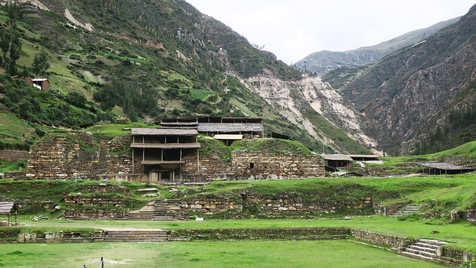
While the Norte Chico is the oldest identifiable civilization along the Pacific Coast, Chavín de Huantar has also captured much attention as a crucible site for Andean culture. Chavín de Huantar is the iconic representation of The Late Initial Period (1,800–800 BCE), when Peru saw the beginnings of a mix of Andean, coastal, and Amazon cultures. Chavín is located at an altitude of more than 3,000 meters in the Callejon de Conchucos, the easternmost basin between the Cordilleras Negra and Blanca in the Peruvian Andes. The central geographical feature of their territory was the Andes which rose up in a dramatic vertical geography that left little room for the development of traditional agriculture. Many Chavin towns were located at very high altitudes, and they appear to have taken advantage of every zone. They were also midway between the coast and jungle, giving communities access to the culture and resources of the greater Andean region. This access made the region a pilgrimage center, an importer of luxury goods, and a key facilitator in the spread of Andean culture (Stone 2012). Their capital, Chavin de Huantar, was located at the intersection of several major trade routes, and the Chavin, like the Olmec in Mesoamerica, appear to have impressed the peoples around them with their sophistication and achievements through the medium of trade.
The Chavin culture eventually fell into decline, and cities such as Chavin de Huantar were abandoned. Though it is not clear exactly why, this does coincide with a period of widespread warfare in the archaeological record. Archaeologists have found marine shell trumpets in the tunnel complex under the city and have attempted to replicate how sound would contribute to the mind-altering rituals undertaken at the complex (Stone 2012). At Chavín, it also seems that there was a priestly leader, like in Egypt. It was, therefore, through spiritual power that the state congealed and grew, as well.
Moche
Chavín de Huantar was not a developed civilization, but it did help establish the importance of religion and ceremonial life in the Andes, both in everyday practice and in sacred sites. Later, other groups in Peru, groups like the Moche, would build on religion and ceremony to help with state formation. The Moche began to conquer the North coast valleys in 200 BCE and, by 250 CE, had begun to construct the Huaca del Sol or temple of the sun and the Huaca de la Luna or temple of the moon at their capital, which bore the same name. The Huaca del Sol seems to have been a royal residence and the Huaca de la Luna a place of worship. The Huaca del Sol contained over 143 million bricks, arranged into columns and marked with symbols, perhaps of who made them (Adams 1997, 106). Each column probably represented a tax-paying Ayllu (kinship-based community), meaning that the Huaca or temple was a literal representation of how the empire was held up by its individual units.
There is still some debate about how much centralization there was at the upper echelons of Moche politics, but there was undoubtedly a leadership class with several administrative levels. The first administrative level was that of the divine kings who are depicted in murals and ceramics from this period. The second was of noble administrators. Below that were bureaucrats who organized the already existing clan system. Below them were the long-standing clan leaders. The lowest level was composed of commoners, many of whom lived in single story adobe houses. Most commoners mastered some craft like metallurgy or weaving. Others were highly skilled and perhaps worked exclusively for the rulers.
Residents living outside of the capital were almost exclusively farmers who lived along the Moche’s extensive irrigation canals – in the Chicama Valley, there is a 120 km long canal still in use today. The Moche found a very practical application of the coastal-mountain symbiosis through the llama. The llama is a domesticated mountain pack animal that the Moche used to journey to the coast and gather guano at the Chincha Islands for fertilizing their valley farms. By 600 CE, the city of Moche covered an area of a square kilometer and probably had a population of 15,000. Each conquered valley outside of the capital had its own huaca, and each one was connected to Moche by relay runners who carried messages written in the form of lines and dots on Lima beans.
Perhaps the most notable Moche legacy was their art. Their buildings, their murals, and their pottery alike reflected their great skill. The Huaca del Sol at Cerro Blanco for example contained millions of bricks and more than 100 types of geometric symbols. Moche murals contained a unique series of squares depicting both abstract and mythological concepts involving themes of creation, combat, sacrifice, and men-jaguars. As already mentioned, this sacrifice may not have always been violent, may not have been literal, and always has a functional explanation. In this case, sacrifice was designed to terrify or at the very least impress a subject population. While it is important to contextualize this sacrifice, we must also remind ourselves that this was not a modern civilization with a middle class or even a democratic tradition. It was archaic in the sense that a small group of people was supported by a large population underneath them. This kind of relationship required brutality to sustain it.

Peoples of the Peruvian South Coast
The south coast of Peru developed somewhat distinctly because it is extremely arid. In certain areas along the coast there has never been recorded rain. Surviving there meant accessing and controlling Andean runoff that sometimes went underground. As a result, the south coast’s population was much smaller, but in many ways was culturally richer.
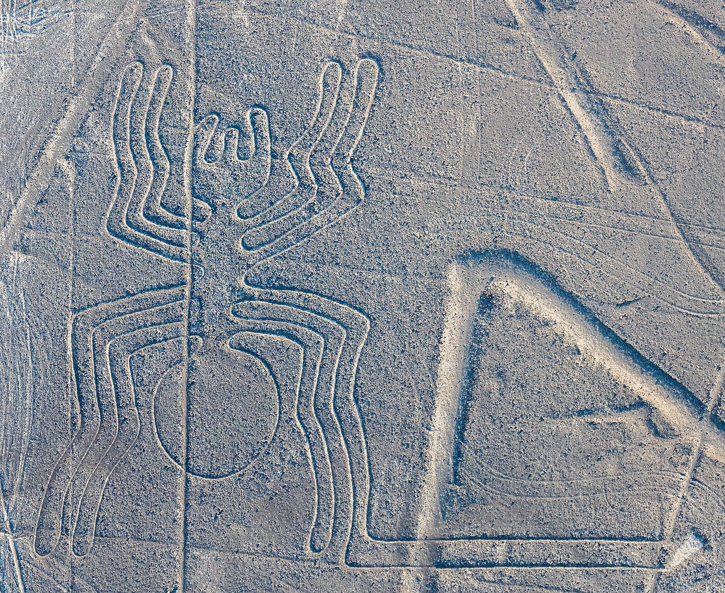
The Nazca carved out their civilization along the south coast between 100 BCE to 600 CE. There was a large center at Cahuachi as early as 200 BCE, but it was largely ceremonial rather than residential. Forty huacas (pyramid mounds) were also built in the areas surrounding Cahuachi but were without large permanent populations. The Nazca maintained a regular pilgrimage to Cahuachi involving music, feasts, and fertility rites. There was some captive sacrifice, but it is not clear of whom. Nazca leadership was probably a confederacy of clans, making the forty huacas the hubs of political and sacred activities.
The Nazca are well known for their pottery and textiles. Their pottery depicted mythical feline or otter figures, many of which were associated with water and fertility—in this climate, water essentially is fertility. The same figures are represented on the Nazca lines/geoglyphs that were created by clearing the desert floor of stone and leaving the motifs. The straight lines were probably “ritual walkways.” Others argue that the Nazca Lines were an astronomical calendar centered around the agricultural cycle. Overall, the Nazca had an impressive but brief florescence which came to an abrupt end after a prolonged drought in the 550s CE (Adams 1997, 209).
THE AMERICAS: NORTH AMERICA
While most evidence points to human migration through North America to South America, the hallmarks of civilization would arrive later in what are now the United States and Canada. Many of us refer to the areas connected by Panama simply as “The Americas,” but the Panamanian land bridge first linked the two continents only two million years ago. This was prior to human arrival in the Americas, but this separate development meant that North and South American flora and fauna experienced millions of years of separate development and evolution. This distinct development would influence the pace and patterns of human settlement in the Americas a great deal. In particular, the great diversity of climates and environments in North America facilitated great linguistic and cultural diversity among its early inhabitants.
The West
The arrival of maize, beans, and squash from northern Mexico helped mark the transition to sedentary culture in the Southwest of what is now the United States. There is some evidence of primitive maize dating back to the middle of the 2nd millennium BCE, but it would not become widespread until about 1000 BCE. However, a different strain of maize, better adapted to arid climates, “Maiz de Ocho,” is believed to have been the key to the flourishing of sedentary villages across the Southwest and to the eventual appearance of large pithouse villages around 500 BCE. In addition to its adaptation to aridity, Maiz de Ocho yields larger kernels which are more easily milled. Pithouses, dwellings whose name indicates that their walls were in fact the sides of an excavated pit, became widespread across the Southwest because they were “thermally efficient.” They lost less heat than above ground structures in winter and were cooler in the summer. Pithouses remained in wide use in the area until about 700 CE, when more complex exchange networks and social organization led to more diverse settlement patterns (Fagan 2000, 306).
Learning in Action – The Pueblo Farming Project
Watch the video: “More than Planting a Seed”, Crow Canyon Archaeological Center 2017
Link: https://www.youtube.com/watch?t=578&v=2x23FF_kUyo&feature=youtu.be
This video is about the Hopi, descendants of ancient Pueblo peoples. The video is cued up to start at 9:38, however, we encourage watching the entire clip.
Environment in History – Deforestation in the Americas
Early American agricultural societies offer instructive cases of how deforestation and depletion of the soil can undermine the integrity of a society. One can point to problems faced in the ‘cradle’ hearth region of the Mexico valley as well as in South West North America in places like Mesa Verde and Chaco Canyon, where societies abruptly collapsed after centuries of cultivation. A prominent theory is that these pueblo building peoples employed agricultural practices that resulted in salination of fields, and accelerated soil erosion through deforestation in a fragile environment, one prone to periodic droughts. Trees were cut to create fields, and for building and fuel, but these practices decreased water in the area and reduced cover for soil. When an intensive period of drought hit, yields failed, soil was blown away and these societies were not able to rebound. Deforestation is also linked to decline in rainfall since loss of trees disrupts the hydrologic cycle; less moisture is absorbed back into the atmosphere through evapotranspiration coming down later as precipitation. Less water evaporated means fewer clouds so over time there is less rainfall.
The most dramatic case of decline in the Americas caused by, or certainly exacerbated by, deforestation, soil degradation and declining agricultural production involved the Maya. The Maya kingdoms, located in Central America, reached their peak, their Classical age, between 300-800 CE. Total Maya population is estimated to have been between 2-6 million in 800 CE; great cities such as Copan and Tikal had massive populations. Supported by a staple crop of maize (corn), the Maya created a society based on extensive agricultural and advanced irrigation.
To feed growing populations, the Maya employed double cropping techniques (putting increased pressure on the land), drained wetlands, and utilized slash and burn techniques in the forests. Pollen records make clear the results of widespread deforestation: soil erosion, evapotranspiration and salinization, and nutritional depletion. Droughts became more frequent, with further destructive effects on the soil and increased wind erosion. Pre-Columbian American peoples did not have the domestic animals available to those in the ‘Old World’ e.g. horses, mules, cows, pigs. Not only did this make cultivated agriculture harder, it meant no animal manure to extend soil productivity. Some use of ash was employed as fertilizer, but this meant further cutting and burning of trees. Deforestation worsened preexisting drought conditions. Some scholars believe it resulted in a decrease in precipitation by as much as 5 to 15%.
Additionally, in the tropical environment of Mesoamerica, soil formation was slow, leading to the need to continually cultivate new areas to support a growing empire. This led to continual deforestation and planting in more fragile areas. The need for timber for construction and to fuel the fires required for lime plaster production led the Maya to cut further and further into hillsides, areas highly vulnerable to soil erosion. The Maya did make some visible efforts to preserve their soil, for example, through the use of terraces to prevent soil runoff. But the grim combination of trying to provide for a relentless population growth, the inherent limits of tropical soils, and extensive deforestation carried out, had devastating consequences. These consequences included: collapse in crop yields, political instability, and increased turmoil and violence. Ultimately these factors contributed to the collapse of the civilization itself.
By the 9th century CE, populations were plummeting; by 850 CE, two thirds of the population of the once great city of Tikal were gone as people abandoned the cities. People survived and their descendants preserved Maya culture, religion, and languages but the Maya as a cohesive and urban civilization ceased to exist. With the collapse of the Maya, the ecosystem actually did recover to some degree due to the complete abandonment of unsustainable cultivation in these areas. Reforestation and soil growth took place from the 9th century on; in some areas, forests grew back to the point many of the great Mayan cities had to be ‘discovered’ in reclaimed jungle growth. The soil, however, has still not fully recovered and modern population surges again threaten this ecosystem.
Another example of the dangers of damaging the soil was the Anasazi, located in the Southwest region of North America. This civilization emerged around the 1st millennium CE (perhaps earlier), and experienced decline and then collapse between the 6th and 14th centuries CE. There are still many mysteries associated with the Anasazi, a society fragmented into several settlements, extending over hundreds of miles. They utilized highly advanced building techniques to construct large settlements, some elevated in cliffs, as well as a vast network of roads that linked this widespread culture.

The Anasazi civilization arose during a period when a number of Southwest communities carved out agricultural settlements in this challenging region. Located away from large rivers, societies like the Anasazi relied on rainwater, and that rainfall was limited. The semi-arid environment meant they faced not only irrigation challenges and easily exhausted soils, but also slow tree growth. Thus when the Anasazi cut down surrounding junipers and pinyon pines for fuel and construction, these forests could not regenerate in semi-arid conditions. Forests were permanently eliminated, leading not only to loss of needed timber resources (wood, nuts, seeds), but also the end of environmental benefits from the trees in absorbing and retaining water. In addition, the permanent elimination of woodlands accelerated wind and rain erosion of what was already fragile soil base. Ultimately settlements faced unendurable drought and famine. The Anasazi settlements were abandoned by the 1300s.
Humans have impacted their environment throughout the duration of their existence on Earth. However, the speed and extent of human induced climate change has greatly accelerated since the Industrial Revolution. The reasons for this are multifaceted and are related not only to industrialization, but are also tied to imperialism, the Green Revolution in farming, and population growth. The consequences of climate change, including global warming, are reflected in the worldwide increase in extreme weather events. While there is much to be concerned about, there have also been a number of initiatives aimed at alleviating the impact of humans on the environment. One such case can be found in modern-day Guatemala.
The Pacific Coast
Further west, cultures along North America’s Pacific coast were also sedentary, but did not derive their existence from farming. Instead, multiple Pacific coast cultures took advantage of abundant land and ocean resources, such as various fish species, sea mammals, timber, shellfish, waterfowl, game, and wild plants. The abundance of these resources often suggests that coastal cultures were less complex than their contemporaries in the interior, but the ravages of climate required tremendous adaptation over time. During the Late Holocene period alone, from 2000 BCE to the present, periodic colder episodes may have led to consequences as disparate as lakeside flooding, lowering of tree lines, drought, and a reduction of available marsh areas. Northwestern Coastal peoples, for example, addressed this volatility by never putting their eggs in one basket. While they may have primarily eaten acorns or salmon, they made sure to always maintain a secondary food source. Further south, the Chumash, a people inhabiting the central and southern California coast, developed ceremonial centers, provinces incorporating several villages, sophisticated “watercraft,” and vibrant trade with the interior. This trade helped the Chumash avoid scarcities as well (Fagan 2000, 222, 248).
The Plains
The Great Plains represented perhaps the largest area of pre-Columbian North America, but it is also one of the least understood. The Wild West shows of the 19th century produced the lasting yet erroneous impression that the Plains Indian culture remained unchanged for centuries. The truth is more complicated. Big game hunters in the Clovis Culture first inhabited the area as early as 13,000 years ago. As big game became extinct around 9,000 BCE, Paleo-Indian groups on the plains turned to foraging and fishing in river valleys and hunting primarily bison as well as deer and fowl. By 9,000 BCE, the Ice Age had left behind a vast expanse of arid grassland from Alaska to the Gulf of Mexico, an expanse known as the “Great Bison Belt.” Long before European explorers introduced horses, people on the Great Plains had developed sophisticated processes of hunting bison on foot that involved some hunters disguised as bison, orchestrated movements among hunting groups, and others shouting to drive the bison toward pre-selected “traps” or “jumps.” Dozens of bison would fall over a precipice to their deaths. By 6,000 BCE, plains hunters had more sophisticated projectiles that could penetrate the skin of a surrounded animal or one that had become stuck in mud or sand. Findings at the Olsen-Chubbock site in Colorado indicate that by 6,500 BCE, Paleo-Indians had also begun to butcher seventy-five percent of the animals they killed, which could sustain a group of 100 people for more than a month (Fagan 2000, 93-96). Early Plains Archaic (5,600–3,000 BCE) activity, while still largely dependent on bison, shows increasing reliance on fish, fowl, and berries, possibly indicating warmer and drier conditions that “diminished grass cover throughout the Central Plains.” Middle Plains Archaic peoples (2,900 BCE to 1000 BCE) adapted their bison hunting to allow for a more sedentary existence, returning to the same hunting ground year after year, and making much of the bison meat into pemmican (a brick of pounded flesh and fat), that could be stored for seasons when bison were less plentiful (Fagan 2000, 123). By 550 CE, the Late Plains Archaic people had fully incorporated the bow and arrow into their hunts, which tended to be less frequent but more productive, often incorporating “mass kill sites” that were used for hundreds of years in some cases (Fagan 2000, 122-127).
Learning in Action – Buffalo Jumps
Read the article and watch the included video: “What is a Buffalo Jump?”, PBS and Parks of Montana, 2024.
Link: https://kcts9.pbslearningmedia.org/resource/what-is-a-buffalo-jump/video-parks-of-montana/
The Eastern Woodlands
The term ‘Middle Woodland’ is occasionally used to refer to the period between 200 BCE and CE 400; this coincided with the influence of the Hopewell culture over much of eastern North America. Previous to the Hopewell ascendance, the Adena people built hundreds of burial mounds in and around central Ohio (2,300–2,100 BCE). Accompanying the burials were dozens of types of “grave goods” including spear points, stone pipes, and sculptures of animals and human hands. Hopewell mound building (1000–200 BCE) and culture as a whole certainly had antecedents in the Adena and early Woodland cultures as a whole, but the Hopewell tradition stands out in its grandiosity. With their center in the Ohio Valley, the Hopewell created hundreds of hectares of earthworks with regionally specific styles of craftsmanship. Copper, shells, obsidian, and shark and alligator teeth were all used to create personal adornments, containers, pipes, and figurines. Much of this artifact diversity can be attributed to the size and vitality of the Hopewell exchange zone which extended across much of eastern North America from Florida to the Great Lakes. While there is evidence that areas as far away as North Dakota participated in this exchange network, the so-called “core areas” were in the Mississippi, Illinois, Scioto, and Miami river valleys in Illinois and Ohio.
As trade picked up, so did the ceremonial and political significance of the artifacts received by local leaders and ultimately included in burial mounds. Some artifacts were buried with their owners at death as symbols of their power in life. The expansion of ceremony through these objects also meant that many of the Hopewellian centers shared physical characteristics such as both platform and conical mounds, structures for cremation, and burial vaults. The local populations who participated in these ceremonies seem to have lived near, but not in, the ceremonial centers themselves in single or multiple family households. Although close to other residents, Hopewell communities were scattered across the area, subsisting through a mix of foraging and horticulture (Fagan 2000, 417-422).
The Arctic
The Arctic’s harsh climate meant that it was one of the last areas in the Americas to be permanently settled. In addition, the climate has posed challenges to modern day archaeologists. However, intriguing new research has added to our understanding of the early peoples of the Arctic. The first Paleo-Eskimo populations appeared around 4,000 years ago, emanating from Eastern Siberia. The Arctic colonists expanded rapidly across Alaska, through Canada, and into Greenland as they all possessed arctic small tool kits that included toggle headed harpoons to kill walrus and seal. These early migrants were the ancestors of the many diverse indigenous peoples who populate the region today. They typically lived in small kinship bands and mobility enabled them to move throughout the year and live off of natural resources. On the coast, seafood provided sustenance. Walruses and whales were of particular importance and provided not only ample calories, but also the materials for a diverse range of goods. Walrus skin was used in the production of boats, cordage, containers, and more. The ivory from whales and walruses were used as a medium for carved artwork and tools. Whale hunting required great skill and bravery and the ability of a community to carry out a successful whale hunt contributed to social status. Inuit oral histories and excavated artifacts reveal that the whale was highly revered in Inuit society. Hunt participants were required to abide by particular rules and rituals of respect were carried out in honor of the deceased whale. Caribou was also an important source of protein and hides, with all useful parts of the animal carefully utilized. Use of sled dogs would have helped early Arctic peoples to transport their goods across far distances. Recent DNA analysis comparing modern sled dogs with an ancient Siberian dog led researchers to hypothesize that “sled dogs could have been genetically distinct from other dogs around 15,000 years ago” (Metcalfe 2020). Additionally, the ancient dog and modern sled dogs appear to have adapted well to intensely cold weather with longer fur, thick foot pads, and the ability to “thrive on a fat-rich and starch-poor diet, which became normal for humans in the Arctic several thousand years ago” (Metcalfe 2020).
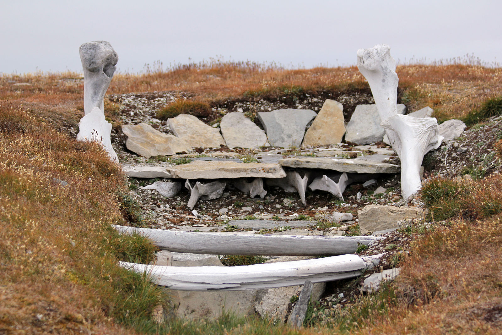
The climate made large scale agriculture infeasible and thus large permanent settlements for early Arctic inhabitants were not established, or at least, have not yet been discovered. However, in some areas archaeological evidence dating back to the 11th century CE has indicated that early peoples built subterranean homes to winter in, using driftwood, whalebone, and stone. Additionally, archaeologists have found ceramic vessels, used for cooking and to provide light during long winter months, at various sites in Alaska. Scholars believe that ceramic technology likely originated across the Bering strait, in Russia, and was adopted in Alaska between 2500-3000 years ago. The study of the materials used in production and artistic styles of pottery has indicated that “social networks were, and continue to be, essential to sustained human occupation of Arctic environments. Individuals and groups with wider social connections were more resilient during periods of increased environmental variability and uncertainty, and in the face of social change” (Anderson, Ponkratova, Zhushchikhovskaya 2021). Intriguingly, in 2016 archaeologists discovered a “metal bead and a belt buckle that date from between 1100 to 1300 – a period of time when the Thule people, ancestors of the modern Inuit, inhabited [Seward Peninsula in Alaska]” (Daley 2016). These items indicate trade between North American Arctic peoples and Asia, a practice that scholars had long suspected but lacked evidence for.
Just as research on the peoples of the Arctic has revealed new understandings about trade, scholarship on the many indigenous peoples of the Americas continues to grow based on material evidence from archeological sites, scientific analyses, the oral histories and cultural practices of modern day descendants, as well as partnerships with indigenous groups. Similarly, critical scholarship on Moananuiākea has expanded our understanding of what is commonly referred to as the Pacific Ocean.
Reading the Past – Caribou and the Nunamiut
Read: “Nunamiut: The Caribou People”, NPS, 2021
Link: https://www.nps.gov/articles/000/nunamiut-the-caribou-people.htm
Read: “The Long Walk: The Origins of Anatuvuk Pass”, NPS, 2021
Link: https://www.nps.gov/articles/000/the-long-walk-origins-of-anaktuvuk-pass.htm
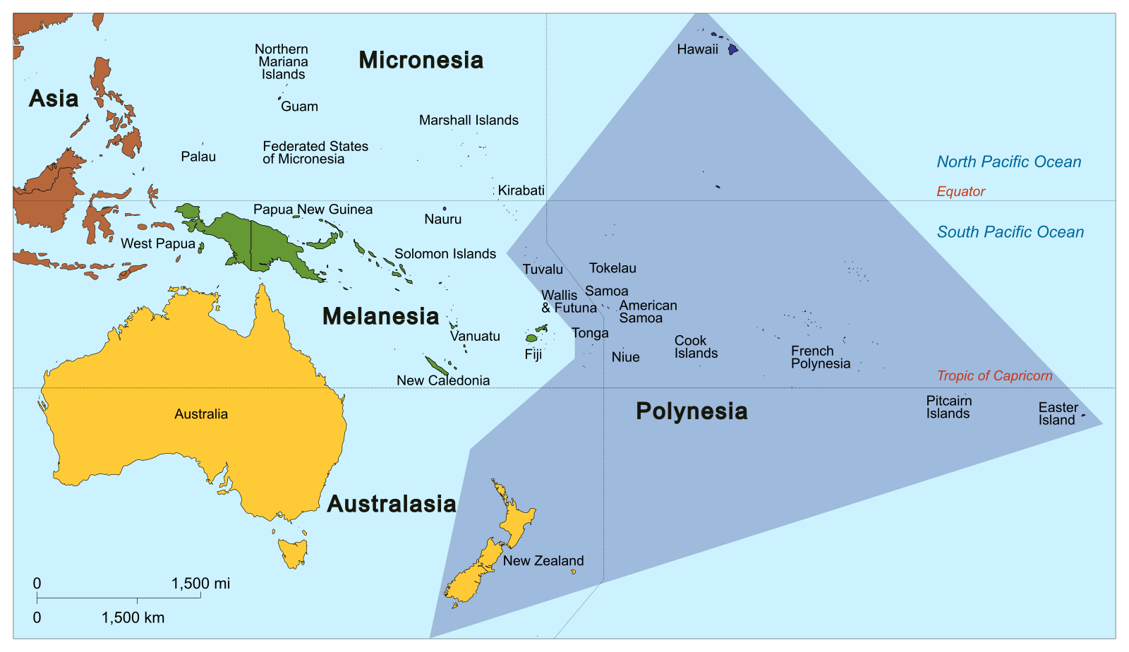
MOANANUIĀKEA (The Pacific)
Migrations throughout Moananuiākea
Using the extraordinary navigational knowledge of wayfinding, voyagers explored the world’s largest ocean, discovering and settling islands separated by thousands of miles of Pacific waters. By the end of this age of exploration, almost 1,500 islands were settled, out of the estimated 25,000 islands scattered across the Pacific. Far flung settlements stretching across millions of square miles created the cultures of Moananuiākea, a civilization made up of numerous societies with shared cultural elements as well as distinctive local differences. The study of migrations and settlement of islands in areas today referred to as Melanesia, Micronesia and Polynesia is a dynamic, fluid field of study. There are competing and varying estimates for settlement so while consensus dating is used here, it is important to recognize dates are still being debated.
Migrants from the Asian mainland first settled islands in Melanesia including New Guinea, the Solomon Islands and the Bismarck Archipelago by 25,000 BCE. The Bismarck Archipelago became home to the evolving Lapita culture, the foundational ancestral cultural center of later Polynesian and Micronesian societies. Sometime around the 12th century BCE, new voyaging efforts led migrants to settle other islands in Melanesia and in Western Polynesia including Fiji, Tonga and Samoa by 800 CE. Later expeditions continued settlement of other islands in Melanesia and Western Micronesia. After about 1000 CE, another influential wave of Polynesian voyages led to settlement of islands in remote Oceania to the Cook Islands and Society Islands such as Tahiti. Then between 300–1000 CE, the final wave of Polynesian migrations settled the Hawaiian islands, as well as reaching the most distant Pacific island, Rapa Nui (Easter Island). The final site Polynesian navigators and settlers reached was Aotearoa (New Zealand), by about 1,200 CE.
These far reaching voyages were made possible by advanced developments in canoe building, as well as abilities to cultivate and store food supplies, and to preserve and pass on navigational wisdom. Navigators relied on a sophisticated and complex understanding of the natural world at sea: the stars, ocean swells and colors, winds, cloud formations, and birds. Of particular importance was the star compass, a mental construct that aided navigation. According to master navigator Nainoa Thompson, “We have Hawaiian names for the houses of the stars- the place where they come out of the ocean and go back into the ocean. If you can identify the stars as they rise and set, and if you have memorized where they rise and set, you can find your direction. The star compass also reads the flight path of birds and the direction of waves. It does everything. It is a mental construct to help you memorize what you need to know to navigate” (On Wayfinding).
Learning in Action – Voyaging
Watch the video: “Take a video tour of the Hōkūleʻa voyaging canoe”, Hawaiʻi News Now, 2017.
Link: https://www.hawaiinewsnow.com/story/36221879/take-a-video-tour-of-the-hokulea-voyaging-canoe/
Reading the Past – The Voyages of Ru
Read: “Ru, Timi Koro”, from the Journal of the Polynesian Society, Vol. 43, trans Drury Low, 1934.
Link: https://archive.hokulea.com/ike/moolelo/ru.html. Make sure to also read the footnotes.
Cultures found throughout Moananuiākea still reflect many shared common cultural elements transported and transplanted by those early voyagers. After the initial voyages and settlement, trade interactions continued between some islands. The extent and commonality of these continual voyages is still being studied. Analysis of stone tools and other stone artifacts in Tonga reveal numerous items with origins from throughout the Tongan archipelago, Fiji, Samoa, and Tahiti, indicating the existence of lasting political and trade networks. Stone items found in a royal Tongan tomb dated to 1550-1600 CE were found to be of Tongan, Samoan, and Fijian origin.
Hawaiʻi
Archaeological, ethnobotanical, and linguistic research supports the argument for west to east migration and settlement throughout Moananuiākea. Distinctive pottery fragments, referred to as Lapita pottery, have been found throughout the region. Additionally, “of the 72 plants identified as having been transported to Polynesia by people, 41-45 are found in the Cook Islands, the Society Islands, and Hiva [Marquesas]; 29 are found in Hawaiʻi, including taro, breadfruit, sugar cane, bamboo, ti, yam, banana, ʻawa, paper mulberry, kukui, coconut, gourd, sweet potato, and mountain apple” (Notes on the Discovery and Settlement of Polynesia). Linguistic analysis reveals great similarity between the language used in Hiva (Marquesas) and Hawaiʻi. Linguists have also noted that some words are shared only between Tahitian and ʻōlelo Hawaiʻi. Thus, scholars believe that the first wave of settlers in Hawaiʻi arrived from Hiva by 500 CE and were followed by later waves of settlers from Tahiti. These later settlers arrived beginning in 1000 CE and voyaged between Hawaiʻi and Tahiti for around 400 years.
Hawaiian records reflect this rich history of voyaging. In The Moʻolelo Hawaiʻi of Davida Malo, Malo writes “it is thought that [Hawaiians] came from the archipelago of Kahiki [Tahiti] and the nearby archipelagoes, because the name of Kahiki was known to the people of old; it is found in the chants, the prayers, and the tales of the Hawaiians of old” (Malo 2020, 74). Malo notes that migration was incremental and involved some form of back-and-forth voyaging between Hawaiʻi and Tahiti, a route of over 2000 miles. He relates the history of Pāʻao, an individual who sailed to Hawaiʻi from Tahiti, took up residence in Kohala and then returned to Kahiki to fetch Pili, an aliʻi. On the return voyage Pāʻao and Pili were accompanied by various others and sailed aboard the canoe, Kanaloamuia.
Learning in Action – Loko Iʻa Restoration
Read: “Hawaiian Fishponds, Providing Physical and Cultural Sustenance”, NOAA Fisheries, 2021.
Link: https://www.fisheries.noaa.gov/feature-story/hawaiian-
fishponds-providing-physical-and-cultural-sustenance
Watch the video: “Fishponds and Aquatic Sustainability”, Aloha Authentic, 2020. Link: https://www.youtube.com/watch?v=lauTelZsQeA
Modern Issues – Challenges in Studying the History of the Americas and Moananuiākea
This chapter began by pointing out one of the weaknesses in our understanding of the civilizations of the Americas and Moananuiākea, the limits of translation. It is also important to consider the tendency for historians to adopt a myopic focus on the overland migration when studying the arrival of Homo sapiens in the Americas. In Chapter One we talked about discrepancies regarding the date Homo sapiens arrived in the Americas. While there is evidence supporting an overland migration from Beringia, and geographically speaking the Beringia migration is the most logical explanation, some scholars argue that this approach has become “dogma” and even “ideology,” leaving no room for evidence that may challenge this explanation. While we cannot argue that we are close to abandoning the Beringian migration as the most likely theory, there is mounting evidence that suggests a seaborne migration from Asia or even a “Solutrean” migration from Europe ten thousand years before an ice-free corridor opened up in North America. Considering new theories may help us explain how the Americas came to be populated and how civilizations developed so quickly here.
A third weakness in our narrative of the Americas and Moananuiākea involves the demographic collapse of the indigenous population that occurred after the arrival of European diseases, with debilitating effects on cultures. Especially in the Circum-Caribbean, millions of indigenous peoples succumbed to European disease and overwork in the first decades of the 16th century, giving them little opportunity to construct their own historical narrative apart from the one that Europeans were writing. In Moananuiākea the arrival of European diseases had a similar devastating toll on native populations. Rough estimates indicate that the death rates associated with smallpox epidemics in Guam, Nuku Hiva, and Ua Pou in 1863 were 450,430, and 500 out of 1000 (respectively). It is estimated that there were upwards of 800,000 to a million Kānaka in Hawaiʻi when Captain Cook arrived in the Hawaiian islands. By 1920 the U.S. census recorded only 24,000. Although Kānaka were keen to adopt literacy and did compose their own written records throughout this period of population loss, the arrival of Protestant missionaries in the early 19th century placed additional pressure on Hawaiian culture. Missionaries condemned the practice of many aspects of Hawaiian culture including hula. Furthermore, in the years following the overthrow of the Hawaiian monarchy, ʻōlelo Hawaiʻi faced continual assault and its use was banned in schools in 1896. By this time the original goal of utilizing ʻōlelo Hawaiʻi to convert Kānaka Maoli had been achieved and banning use of the language served the colonial goals of political disenfranchisement, assimilation, and suppression of indigenous identity. Combined with high mortality rates, the banning of ʻōlelo Hawaiʻi greatly diminished the population of native speakers. However, this did not result in Hawaiʻi becoming a monolingual state. Rather Hawaiian Creole English (also known as Pidgin English), an amalgamation of ʻōlelo Hawaiʻi and various immigrant languages (including Japanese, Chinese, English, Portuguese, Ilocano, Tagalog etc) that was first established earlier in the 19th century became common vernacular. By the 1980s it was estimated that there were fewer than 2000 ʻōlelo Hawaiʻi native speakers remaining. The 1980s was also part of the Hawaiian Renaissance, a movement aimed at challenging years of cultural and political suppression. A significant aspect of the Renaissance was the grassroots effort to revitalize ʻōlelo Hawaiʻi through the creation of immersion schools. As of result of the tireless work of community leaders, educators, and Kānaka elders by 2019 there were over 21 immersion schools throughout the islands and a 2016 government report concluded that over 18,000 people used both ʻōlelo Hawaiʻi and English in their homes.

In the case of 19th and 20th century North America, Protestant and Catholic missionaries also worked zealously to convert indigenous Americans to their religions and lifestyles. In many instances indigenous Americans were pressured to abandon their gathering and hunting practices and to practice sedentary agriculture. In 19th century North America years of warfare and unfair treaty negotiations culminated in the forced removals of tens of thousands of indigenous Americans from their homelands to reservations. Simultaneously, hundreds of thousands of indigenous American children in both the United States and Canada were removed (often by force) from their families and enrolled in Indian boarding schools. In the United States this practice continued through the 1960s and in Canada, the last boarding school closed in 1998. These schools were premised on a goal of assimilating indigenous children to white European culture by removing them from their culture, communities, and languages. Richard H. Pratt, founder of the Carlisle Indian Industrial School famously stated in 1892 “kill the Indian in him, and save the man” (Kliewer, Mahmud, Wayland). Children were frequently punished for using their mother languages. Today, the schools are infamous for the physical, emotional, and sexual abuse that occurred in their halls. Unknown numbers of children died while attending the boarding schools. In Australia, a similar practice was adopted by the colonial government toward indigenous Australian and Torres Strait Islander children. Between 1910 and 1970 as many as 1 in 3 of these children were taken from their families and sent to boarding schools or missions to be assimilated into white Australian culture. These children are now referred to as the “lost generation” (Pannett 2021).
Thus, when studying history it is necessary to remain open minded to new theories based on reviving or recovering lost cultural records and knowledge. Doing so is one way to acknowledge the consequences of decades of cultural suppression. Indeed, history is a living discipline, one that changes with new research and insights. Additionally, when studying the ancient history of the Americas and Moananuiākea it is necessary to also take into consideration the consequences of the last few centuries of colonization and imperialism in the regions. Doing so enables us not only to think critically about the types of sources (and perhaps lack of sources) available for use, but also challenges us to reckon with the past.
Learning in Action – Indigenous Language Revitalization
Watch the video: Haa Léelkʼu Has Yoo X̲ʼatángi: Our Grandparents’ Language
This video is about language revitalization efforts within the Tlingit community in the Pacific Northwest Coast and Alaska
Watch the video: Hoʻi ka ʻŌlelo: The Revitalization of Hawaiian Language in the Education System
This video is about language revitalization efforts within the Kānaka community in Hawaiʻi.
SUMMARY
Humans migrated to the Americas by 15,000 BCE and perhaps as many as 3,000 years before. Overseas migration beginning in mainland Asia and stretching throughout Moananuiākea began as early as 25,000 years ago. In both regions settlements were shaped by their environments with humans utilizing both gathering and hunting and agricultural techniques to sustain their communities. Complex cultures developed that featured craft specialization, organized religion, social hierarchies, and, in some cases, urban centers. Humans in both the Americas and throughout Moananuiākea were impacted by centuries of relative isolation from outside civilizations. For example, in Moananuiākea isolation meant what was produced by island eco-systems was the sole basis for survival. Those cultures that survived did so through adoption of traditions that emphasized sustainable use of resources. Another significant effect of isolation that peoples of the Americas and Moananuiākea shared was the fact that isolation led these cultures to lag behind military developments in Asia, the Near East and Europe. This meant greater vulnerability to conquest once Europeans began sailing, trading, exploring and annexing from the 15th through the 19th centuries. Isolation also resulted in no exposure to zoonotic diseases that originated in animals common in Europe and Asia and thus fewer developed societal immunities. Once isolation ended and new diseases were introduced, indigenous peoples in these regions were devastated by several deadly epidemics introduced by European sailors. In the years that followed European arrivals, indigenous communities struggled to maintain their political sovereignty, religions, and cultural practices. While the demographic and cultural losses should not be underestimated and inequities tied to colonization continue to persist, it is also important to recognize the resilience and vitality of these cultures today.
WORKS CITED AND FURTHER READING
- Adams, Richard E.W. 1997. Ancient Civilizations of the New World. Boulder: Westview Press.
- Allen, Jane. 1991. “The Role of Agriculture in the Evolution of The-Contact Hawaiian State.” Asian Perspectives 30 (1): 117–32. https://scholarspace.manoa.hawaii.edu/server/api/core/bitstreams/68b6cd46-3ebf-44fc-b9eb-9089473ca1cb/content.
- Anderson Shelby and Irina Ponkratova, Irina Zhushchikhovskaya. 2021. “Studying Long-Term Patterns of Bering Strait Cultural Interaction and Exchange Through Archaeological Ceramic Analysis.” Alaska Park Science, Beringia: A Shared Heritage, 20 (2): 26–35. https://www.nps.gov/articles/000/aps-20-2-4.htm.
- Bourget, Steve and Kimberly L. Jones, ed. 2008. The Art and Archaeology of The Moche: An Ancient Society of the Peruvian Coast. Austin: University of Texas Press.
- Bradley, Bruce and Dennis Stanford. 2004. “The North Atlantic Ice-Edge Corridor: A Possible Palaeolithic Route to the New World.” World Archaeology 36 (4): 460.
- Cartwright, Mark. 2018. “Olmec Civilization.” World History Encyclopedia. April 4, 2018. https://www.worldhistory.org/Olmec_Civilization/.
- Clark, Geoffrey and Christian Reepmeyer, Nivaleti Melekiola, Jon Woodhead, William R. Dickinson, Helene Martinsson-Wallin. 2014. “Stone Tools from the Ancient Tongan State Reveal Prehistoric Interaction Centers in the Central Pacific.” PNAS 111 (29). https://doi.org/https://doi.org/10.1073/pnas.1406165111.
- “Cracking the Maya Code.” n.d. NOVA. Accessed July 28, 2023. https://www.pbs.org/wgbh/nova/mayacode/time-nf.html.
- Daley, Jason. 2016. “Bronze Buckle Shows Ancient Trade Between Eurasia and North America,” June 13, 2016. https://www.smithsonianmag.com/smart-news/bronze-buckle-shows-trade-between-asia-and-north-america-180959378/.
- Dekneef, Matthew. 2018. “Hawaiians Have More than 200 Words for Rain.” Hawaii Magazine, 2018. https://manoa.hawaii.edu/sealearning/sites/default/files/Hawaiians%20have%20more%20than%20200%20words%20for%20rain%20_%20Hawaii%20Magazine.pdf.
- Demby, Gene. 2015. “It Took Two Centuries, But The Native Hawaiian Population May Be Bouncing Back.” Code Switch. April 18, 2015. https://www.npr.org/sections/codeswitch/2015/04/18/398578801/it-took-two-centuries-but-the-native-hawaii-ans-has-finally-bounced-back.
- Fagan, Brian M. 2000. Ancient North America: The Archaeology of a Continent. Third. New York: Thames and Hudson.
- Haas, Jonathan and Winifred Creamer. 2006. “Crucible of Andean Civilization: The Peruvian Coast from 3000 to 1800 BC.” Current Anthropology 47 (5): 746.
- Kliewer, Addison and Miranda Mahmud, Brooklyn Wayland. 2021. “‘Kill the Indian, Save the Man’: Remembering the Stories of Indian Boarding Schools.” Gaylord College of Journalism and Mass Communications. December 8, 2021. https://www.ou.edu/gaylord/exiled-to-indian-country/content/remembering-the-stories-of-indian-boarding-schools.
- Landlas, Charles and Jeffrey Lyon, ed. 2020. The Moʻolelo Hawaiʻi of Davida Malo. Vol. 2. Hawaiʻi: UH Press.“Laws, Governance & Social Structure.” 2019. National Park Service. August 19, 2019. https://www.nps.gov/locations/hawaii/social-structure.htm.
- “Letters from Hernán Cortés.” n.d. American Historical Association. Accessed July 28, 2023. https://www.historians.org/teaching-and-learning/classroom-content/teaching-and-learning-in-the-digital-age/the-conquest-of-mexico/letters-from-hernan-cortes/cortes-de%C2%AD%20scribes-tenochtitlan.
- “Maya Codices.” n.d. New World Encyclopedia. Accessed July 28, 2023. https://www.newworldencyclopedia.org/entry/Maya_codices.
- McDaniel, Josh. n.d. “The Return of Kū‘ula of Hawaiian Fishponds.” Sea Grant University of Hawaiʻi. Accessed July 28, 2023. https://seagrant.soest.hawaii.edu/the-return-of-kuula/.
- Metcalfe, Tom. 2020. “Ancient Sled Dogs Helped Ice-Age Humans Conquer the Cold.” Science News. June 25, 2020. https://www.nbcnews.com/science/science-news/ancient-sled-dogs-helped-ice-age-humans-conquer-cold-n1232100.
- Mithen, Steven. 2003. After the Ice: A Global Human History, 20,000 – 5000 BC. London: Weidenfeld & Nicolson.
- “Moananuiākea.” n.d. Kaʻiwakīloumoku. Accessed July 31, 2023. https://kaiwakiloumoku.ksbe.edu/moananuiakea.
- Mueller-Dombois, Dieter. 2007. “The Hawaiian Ahupua‘a Land Use System: Its Biological Resource and the Challenge for Silvicultural Restoration.” Bishop Museum Bulletin in Cultural and Environmental Studies 3: 23–33. http://hbs.bishopmuseum.org/pubs-online/strm/04-Mueller-Domboisr.pdf.
- Nakata, Shari. “Language Suppression, Revitalization, and Native Hawaiian Identity.” Diversity & Social Justice Forumʻs The Forum 2 (Fall 2017): 14–27. https://www.chapman.edu/law/_files/publications/2017-dsj/reneer.pdf.
- “Notes on the Discovery and Settlement of Polynesia.” n.d. Hawaiian Voyaging Traditions. Accessed July 28, 2023. https://archive.hokulea.com/ike/moolelo/discovery_and_settlement.html.
- Oliveira, Katrina-Ann R. Kapāʻanaokalāokeola Nākoa. 2014. Ancestral Places: Understanding Kanaka Geographies. Oregon: Oregon State University Press.
- “Overview of Hawaiian Prehistory.” 2001. A Cultural History of Three Traditional Hawaiian Sites on the West Coast of Hawai’i Island. November 15, 2001. https://www.nps.gov/parkhistory/online_books/kona/history1f.htm
- Pannett, Rachel. 2021. “Australia to Pay Hundreds of Millions in Reparations to Indigenous ‘Stolen Generations.’” The Washington Post, August 5, 2021.
- https://www.washingtonpost.com/world/2021/08/05/australia-indigenous-school-reparation/.
- Pauls, Elizabeth Prine. 2023. “Olmec People.” Britannica. July 25, 2023. https://www.britannica.com/topic/Olmec.
- Pool, Christopher. 2007. Olmec Archaeology and Early Mesoamerica. Cambridge: Cambridge University Press.
- Rallu, Jean-Louis. 2022. “Patterns of Population Decline Following European Contact and Colonization: The Cases of Tahiti and the Marquesas.” Population and Economics 6 (2): 88–107. https://www.researchgate.net/publication/362444942_Patterns_of_population_decline_following_European_contact_and_colonization_The_cases_of_Tahiti_and_the_Marquesas.
- Read, Kay Almere and Jason J. Gonzalez. 2000. Handbook of Mesoamerican Mythology. Santa Barbara: ABC-CLIO.
- Reilly III, F. Kent. 2000. “Art, Ritual and Rulership in the Olmec World.” In The Ancient Civilizations of Mesoamerica : A Reader, by Michael Restall, Matthew and Amara Solari. 2011. 2012 and the End of the World: The Western Roots of the Maya Apocalypse. Lanham, MD: Rowman and Littlefield.
- Smith, Ernest and Marilyn A. Masson. The Ancient Civilizations of Mesoamerica: A Reader. Malden, Mass: Blackwell Publishers.
- Ristvet, Lauren. 2007. In the Beginning: World History from Human Evolution to the First States. 1/e. New York: McGraw-Hill.
- Smith Michael E, and Marilyn Masson, editors. The Ancient Civilizations of Mesoamerica: A Reader. Wiley-Blackwell, 2000.
- Stone, Rebecca. 2012. Art of the Andes: From Chavin to Inca. Third. New York: Thames and Hudson.
- Thompson, Nainoa. n.d. “On Wayfinding.” Hawaiian Voyaging Traditions. Accessed July 28, 2023. https://archive.hokulea.com/ike/hookele/on_wayfinding.html.
- Trubitt, Mary Beth D. 2000. “Mound Building and Prestige Goods Exchange: Changing Strategies in the Cahokia Chiefdom.” American Antiquity 65 (4): 669–90.
- Tung, Tiffany. 2012. Violence, Ritual, and the Wari Empire: Bioarchaeological Interpretations of the Human Past: Local, Region al, and Global Perspectives. Gainesville: University of Florida Press.
- VanDerwarker, Amber. 2013. “Popul Vuh: Mayan Document.” Brittanica. March 21, 2013. https://www.britannica.com/topic/book-publication.
- Wagelie, Jennifer. 2022. “Lapita Pottery (ca. 1500–500 B.C.).” Heilbrunn Timeline of Art History. October 2022. https://www.metmuseum.org/toah/hd/lapi/hd_lapi.htm. N.d.
