The atoms and molecules that make up the various layers of the atmosphere are constantly moving in random directions. Despite their tiny size, when they strike a surface, they exert a force on that surface in what we observe as pressure.
The number of molecules in the atmosphere decreases with height.
Each molecule is too small to feel and only exerts a tiny bit of force. However, when we sum the total forces from the large number of molecules that strike a surface each moment, then the total observed pressure can be considerable.
Air pressure can be increased or decreased in one of two ways. First, simply adding molecules to a container will increase the pressure because a larger number of molecules will increase the number of collisions with the container’s boundary. This is observed as an increase in pressure.
A good example of this is adding or subtracting air in an automobile tire. By adding air, the number of molecules increases, as does the total number of the collisions with the tire’s inner boundary. The increased number of collisions increases the pressure and forces the tire to expand in size.
The second way of changing air pressure is by the addition or subtraction of heat. Adding heat to a container can transfer energy to air molecules. Heated molecules move with increased velocity, striking the container’s boundary with greater force, which is observed as an increase in pressure.
Since molecules move in all directions, they can even exert air pressure upwards as they smash into object from underneath. In the atmosphere, air pressure can be exerted in all directions.
In the International Space Station, the density of the air is maintained so that it is similar to the density at the Earth’s surface, 14.7 pounds per square inch.
Back on Earth, as elevation increases, the number of molecules decreases and the density of air therefore is less, which means there is a decrease in air pressure. In fact, while the atmosphere extends hundreds of miles up, one half of the air molecules in the atmosphere are contained within the first 18,000 feet (5.6 km).This decrease in pressure with height makes it very hard to compare the air pressure at ground level from one location to another, especially when the elevations of each site differ. Therefore, to give meaning to the pressure values observed at each station, we convert the station air pressures reading to a value with a common denominator.
The difference in pressure as height increases.
The common denominator we use is the sea-level elevation. At observation stations around the world, the air pressure reading, regardless of the observation station elevation, is converted to a value that would be observed if that instrument were located at sea level.
The two most common units in the United States to measure the pressure are “Inches of Mercury” and “Millibars”. Inches of mercury refers to the height of a column of mercury measured in hundredths of inches. This is what you will usually hear from the NOAA Weather Radio or from your favorite weather or news source. At sea level, standard air pressure is 29.92 inches of mercury.
Millibars comes from the original term for pressure: “bar”. Bar is from the Greek “báros”, meaning weight. A millibar is 1/1000th of a bar and is approximately equal to 1000 dynes (one dyne is the amount of force it takes to accelerate an object with a mass of one gram at the rate of one centimeter per second squared). Millibar values used in meteorology range from about 100 to 1050. At sea level, standard air pressure in millibars is 1013.2. Weather maps showing the pressure at the surface are drawn using millibars.
Although the changes are usually too slow to observe directly, air pressure is almost always changing. This change in pressure is caused by changes in air density, and air density is related to temperature.
Warm air is less dense than cooler air because the gas molecules in warm air have a greater velocity and are farther apart than in cooler air. So, while the average altitude of the 500 millibar level is around 18,000 feet (5,600 meters) the actual elevation will be higher in warm air than in cold air.
How temperature affects the height of pressure.
The most basic change in pressure is the twice daily rise and fall due to the heat from the sun. Each day, the pressure is at its lowest around 4 a.m./p.m., and at its highest around 10 a.m./p.m. The magnitude of the daily cycle is greatest near the equator, decreasing toward the poles.
On top of the daily fluctuations are the larger pressure changes as a result of the migrating weather systems. These weather systems are identified by the blue H’s and red L’s seen on weather maps.
-end NOAA Jetstream content-
Atmospheric pressure is a force created by the weight of the atmosphere. Because of gravity, air pressure is highest at sea level and decreases with height. There is also high pressure and low pressure. High pressure, also called an anticyclone, occurs when descending air molecules “pile-up” at the surface and spread outward in a clockwise rotation in the Northern Hemisphere. In the Southern Hemisphere, the air within high pressure flows counterclockwise. In either case, the descending air will warm, which prevents water vapor from cooling and condensing into clouds to produce storms. Instead, regions under high pressure tend to experience clear skies. Low pressure, also called a cyclone, occurs when converging air is forced upward (in a counterclockwise manner in the Northern Hemisphere) where it cools and condenses into clouds and possible storms. Ultimately, air flows from high pressure to low pressure, and this is called wind.
When an area of atmospheric high pressure is located near an area of low pressure, there is an imbalance between the atmospheric pressure. The force to balance these two pressure imbalances is called the pressure gradient force, which creates wind. Wind is the horizontal movement of air from an area of high pressure to an area of low pressure.
Atmospheric Lifting Mechanisms
To have cloud formation, the air must be unstable. Stable air means air does not want to rise, cool, and condense. Thus, weather conditions tend to be clear skies with stable air. Unstable air means the air wants to rise, cool, and condense into clouds and potential storms. The forces that cause air to rise are convection, orographic uplift, convergence, and weather fronts.
Convection occurs when air rises, much like a hot air balloon. Because of albedo, some areas on the ground can get heated more than other areas. Where the land heats up more, the air above also warms, becomes less dense, and rises. If the air rises high enough, it may cool and condense to create clouds and possibly thunderstorms.
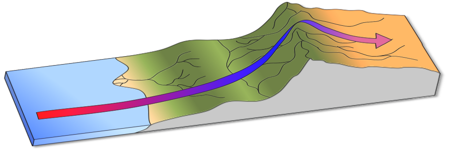
Orographicuplift is when mountains help destabilize air and occur when air must rise over a mountain range. As the air rises over the mountain, the moisture within it may begin to cool and condense to form thunderstorms. Often with orographic uplift, one side of the mountain will be very moist from the storms, while the other side is arid. The dry side of the mountain is called the rainshadow effect. Later we will discuss how this process can generate what is called dry thunderstorms and wildfires.
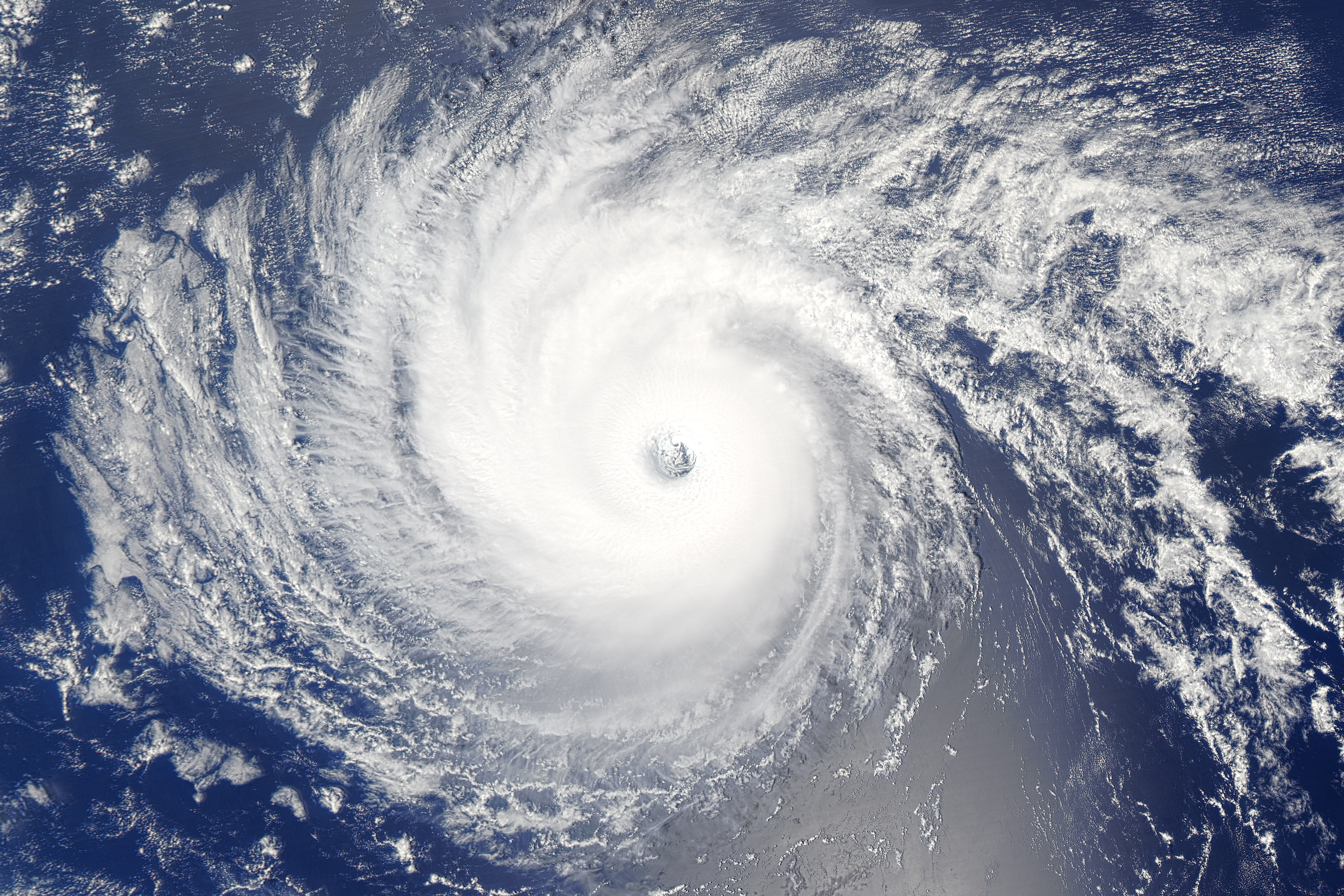
Convergence occurs when air is forced to rise because it rushes together into an area of of low pressure, causing the rising air to cool and condense into clouds. One of the best examples of this is over Florida. Because Florida is a peninsula, surrounded by water on three sides, the land heats up more than the surrounding water. This causes the air above the land to rise. To replace this rising air, humid and cooler air from the Gulf of Mexico and the Atlantic Ocean converges inward over Florida (source). This moist air is heated by the land and is forced upward to create powerful thunderstorms. Florida has more thunderstorms and lightning than any other state in the nation. Another example of convergence is the eye of a hurricane because winds and moisture are rotating around the eye until they converge within the eye.
Finally, weather fronts, such as cold fronts, warm fronts, stationary fronts, and occluded fronts, can force air to rise. For example, a cold front occurs when a cold, dense air mass replaces a warm, lighter air mass. The cold air mass plows through, forcing the warmer air mass upward to cool and condense into clouds.
Coriolis Effect
All free moving objects appear to be deflected to the right in the Northern Hemisphere, and to the left in the Southern Hemisphere, because of the rotation of the Earth. This apparent deflection is called the Coriolis effect.
Aside from a football, what else is considered a “free moving” object? Free moving objects include airplanes, ocean currents, clouds, wind, hurricanes, or anything else that is not attached to the earth’s surface. So how does this influence the atmosphere? As winds flow from high to low pressure, it deflects to the right (in the Northern Hemisphere) because of the earth’s rotation. This deflection is nonexistent at the equator and progressively gets stronger towards the poles. Because of this, hurricanes can only form 5-20 degrees north or south of the equator. Near the equator, the water is warm enough, but the Coriolis effect is too weak to make the hurricane rotate. Beyond 20 degrees latitude, the Coriolis effect is strong enough, but the waters are too cold.