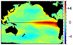

The bright red shows sea surface water temperatures warmer than normal in the Eastern Pacific, indicating the presence of El Niño. (Dec. 1997)
Download Image
4. Global Climates and Past Climate Change
One of the most prominent aspects of our weather and climate is its variability. This variability ranges from small-scale phenomena such as wind gusts, localized thunderstorms, and tornadoes, to larger-scale features such as fronts and storms and multi-seasonal, multi-year, multi-decade and even multi-century time scales.

The bright red shows sea surface water temperatures warmer than normal in the Eastern Pacific, indicating the presence of El Niño. (Dec. 1997)
Download Image
Typically, long time-scale events are often associated with changes in atmospheric circulations across vast areas. At times, these persistent circulations occur simultaneously over seemingly unrelated parts of the hemisphere and result in variations in the normal weather, temperature, and rainfall patterns worldwide.
El Niño is one of these naturally occurring phenomena. The term El Niño (Spanish for “the boy” and a reference to the Christ child) comes from the name Peruvian fishermen gave to a periodic, warm ocean current that was usually observed immediately after Christmas.
It marked a time with poor fishing conditions along the northwest South American coast, while over land, this ocean current brought heavy rains in very dry regions, resulting in an increase in vegetation.
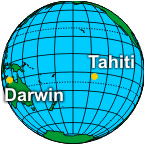
Further research found that El Niño is actually part of a much larger global variation in the atmosphere called ENSO (El Niño/Southern Oscillation). The Southern Oscillation describes changes in air pressure patterns in the Southern Pacific Ocean between Tahiti, in the middle of the southern Pacific Ocean, and Darwin, Australia, to the west.
Normally, lower pressure over Darwin and higher pressure over Tahiti encourages air movement from east to west. This in turn drives the movement of warm surface water westward, creating an ocean circulation that also brings cold, deep, nutrient-rich water to the surface in the eastern Pacific, along northwest South America.
During El Niño conditions, however, the average air pressure in Darwin becomes higher than in Tahiti, slowing these circulations. This change in circulation affects the movement and temperature of air and water across the entire Pacific. As a result, El Niño is associated not only with heavy rain and warmer ocean currents in equatorial South America to the east, but severe drought in parts of the western Pacific, such as Australia.
The occurrence of warmer-than-normal temperatures in the Eastern Pacific suggests that periods of cooler than normal water temperature can also occur. These cooler periods are called La Niña. By convention, when you hear the name El Niño, it refers to the warm episode of ENSO, while the cool episode of ENSO is called La Niña.
ENSO is monitored by looking at pressure differences between Tahiti and Darwin, Australia, using the Southern Oscillation Index (SOI), as well as sea surface temperatures (SST).
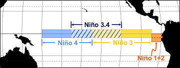
Sea surface temperatures are monitored in four regions along the equator:
These regions were defined in the early 1980s, but research has led to changes in these original regions. The original Niño 1 and Niño 2 are now combined into a region called Niño 1+2.
A new region called Niño 3.4 (120°-150°W and 5°N-5°S) is also now used. It correlates better with the Southern Oscillation Index and is the preferred region to monitor sea surface temperature
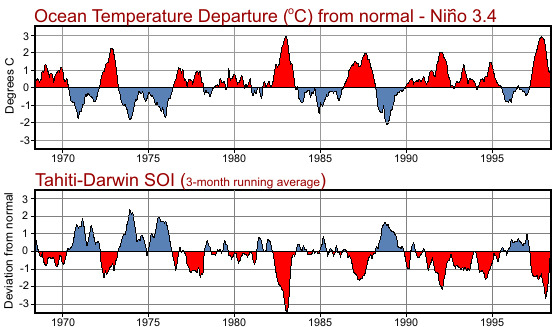
The two graphs above show this correlation. The top graph shows the change in water temperature from normal for Niño 3.4. The bottom graph shows the southern oscillation index for the same period.
When the pressure in Tahiti is lower than Darwin, the temperature in Niño 3.4 is higher than normal, and El Niño is occurring.
Conversely, when the pressure in Tahiti is higher than Darwin, the temperature in Niño 3.4 is lower than normal, and La Niña is occurring.
These changes in sea surface temperatures are not large, plus or minus 6°F (3°C) and generally much less. However, these seemingly minor changes can have large effects on our global weather patterns.