Appendix: Outline Maps
Sources of maps
Pressbooks, which is how this book is created, doesn’t allow PDF files to upload and embed so I suggest using the following links to the BYU Map page and the World Factbook maps when studying.
For many years I used maps produced by the BYU Geography department for my map quizzes. Here’s the link to the BYU Map page.
Another good source of country and regional maps is the CIA World Factbook. The maps section of the World Factbook is here.
How to study for map quizzes.
Actively study
To learn the location of countries and cities and landforms, I recommend printing out several copies of outline maps without labels. Also find a labeled map. Look at 5-7 countries on the labeled map. Observed their shapes, locations relative to each other and oceans and mountain ranges. Look at the labeled map and say ALOUD “Country A is west of Country B and B has this shape…” Next, close your eyes and envision all 5-7 countries.
Now, on the blank map, label those countries. Work in groups of 5-7 items because that’s about all most people can keep track at one time (think about remembering phone numbers with seven digits). Repeat this several times to truly learn those 5-7 locations. Once done, move to another group of 5-7 countries. After doing perhaps 4 different groups, go back to the first group again to make sure you still remember it.
The next step, or concurrent with the above step, is to trace the outline of each country by hand on the paper map. Again say ALOUD “I am tracing the north border of Country A. On the other side is Country D. The shape of the border is a [straight line, follows River X…]”. You should touch (draw), hear (say aloud), and observe (see) the shape and spatial characteristics of the country and borders.
Finally find another map that has only the regional outline, such as Europe without the countries. Now roughly draw in the locations of each country. The first try may have crude circles for approximate locations. Large circles for large countries, small circles for small countries in about the correct location. On a later attempt you should try to duplicate the shape and location of the borders.
Passively study
Get a map or several maps of the region you’re studying and put them on the wall where you will often see them. I like having a map next to the TV, the top of the stairs, the wall opposite the dining room table. You look at the map many times throughout the day and passively learn where places are. You can do the same with math formulas and diagrams of biogeochemical cycles.
Placenames lists
These are the places I include on map quizzes in Introduction to Geography. Only countries, capitals, and some major cities are included. No landforms for this course.
European Place Names
Europe maps: Outline Countries, CIA Names, Regional outlineThe Region: Iceland, UK, to the Russian Border, Scandinavia to the Mediterranean Sea.
Significant cities
EU institutions: Brussels, Frankfurt, Luxembourg City, Strasbourg
Antwerp (diamonds)
Barcelona
Berlin
Cagli, Italy (Spokane Sister City)
Geneva
Limerick, Ireland (Spokane Sister City)
London
Madrid
Milan
Paris
Rome
Rotterdam
The Hague
Countries
Learn all countries and their capitals, other than the micro-states. If you’re short on time, focus on these:
Belgium
France
Germany
Greece
Italy
Norway
Poland
Portugal
Spain
Sweden
Switzerland
Turkey
United Kingdom
Russia and Central Asia
Maps: Outline Countries, CIA Names, Region Outline,
The Region: Former Soviet Union (USSR) Ukraine, Baltic through C. Asia to Pacific.
Countries and capitals:
Armenia
Azerbaijan
Belarus
Estonia
Georgia
Kazakhstan
Kyrgyzstan
Latvia
Lithuania
Russia
Tajikistan
Turkmenistan
Ukraine
Uzbekistan
Baku
Grozny
Minsk
Moscow
Murmansk
Norilsk (non-capital)
Novosibirsk
Nur-Sultan
St. Petersburg
Tashkent
Vladivostok
Mariupol
Odessa
Donetsk
Volgograd
Asia (East and South and Southeast, not Central)
Maps: Outline Countries, Countries Named, Cities, Region Outline
The Region: From Pakistan/Afghanistan to Japan/Philippines, SE Asia to Singapore.
Not the former USSR.
Countries: Pakistan, India, Bangladesh, Burma, Nepal, Bhutan, Afghanistan, India, Maldives, Myanmar/Burma, Sri Lanka, China, Mongolia, Japan, N/S Koreas, Taiwan, Philippines, Cambodia, Vietnam, Laos, Malaysia, Thailand, Myanmar, Brunei and their capitals
Political regions
Guangdong
Major Cities
Bangalore
Chennai (Madras)
Dhaka
Jecheon, South Korea
Jilin City, China
Karachi
Kolkata
Lahore
Mumbai (Bombay)
Nishinomiya, Japan
Chongqing
Guangzhou
Hong Kong
Macau
Shanghai
Urumqi
plus capitals
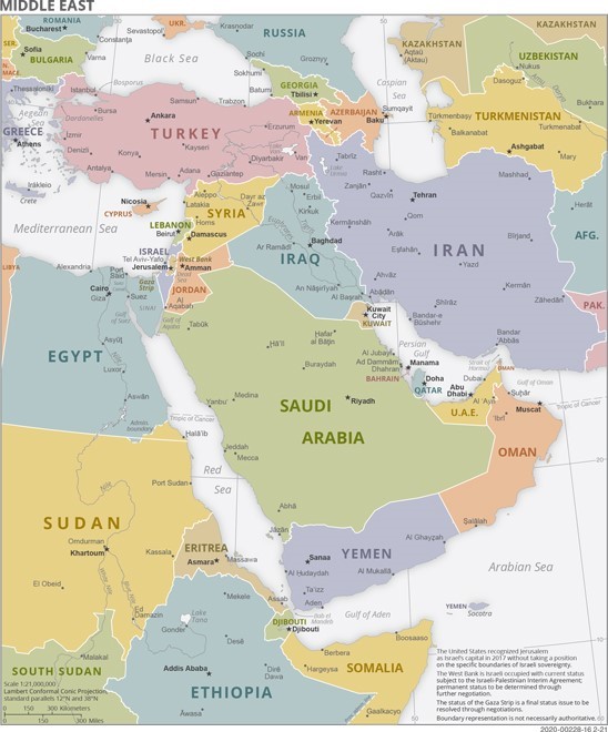
Middle East and North Africa (MENA) orSouthwest Asia and North Africa (SWANA)
Maps: MENA Core, MENA Broad, Outline Broad, Outline Core, Core Named CIA,
The region: All countries and capitals within the area bounded by the Caspian Sea to Persian Gulf, Mediterranean Sea and Red Sea, from Afghanistan to Morocco.
Egypt
Iran
Iraq
Israel
Jordan
Kuwait
Lebanon
Qatar
Saudi Arabia
Syria
Turkey
United Arab Emirates
Yemen
Abu Dhabi
Alexandria
Baghdad
Beirut
Benghazi
Cairo
Damascus
Gaza Strip
Golan Heights
Istanbul
Jerusalem
*Karbala*
Mecca
Medina
*Najaf*
*Qom*
Riyadh
Samarkand
Tehran
Tel Aviv
West Bank
*Shiite holy sites
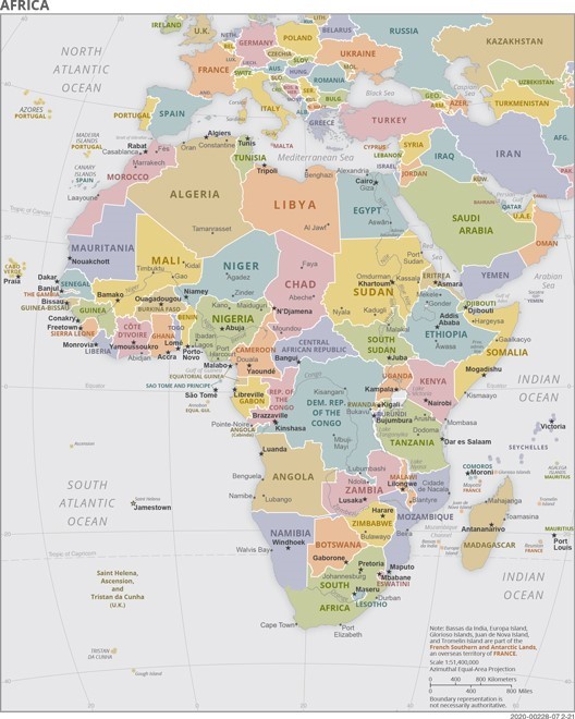
Africa
Maps: Outline Countries, Region Outline, Countries CIA
Know ALL countries of the Sahel and south of the Sahara. Will not include MALE and Tunisia
The Political Geography quiz with include all countries, capitals, plus these important cities:Cape Town, Douala, Lagos, Timbuktu, Dar es Salaam, Dodoma
Note: The capital of Burundi is shifting from Bujumbura to Gitega as of late 2019.
The capital of Tanzania is officially Dodoma. Dar es Salaam is the economic & historic capitol.
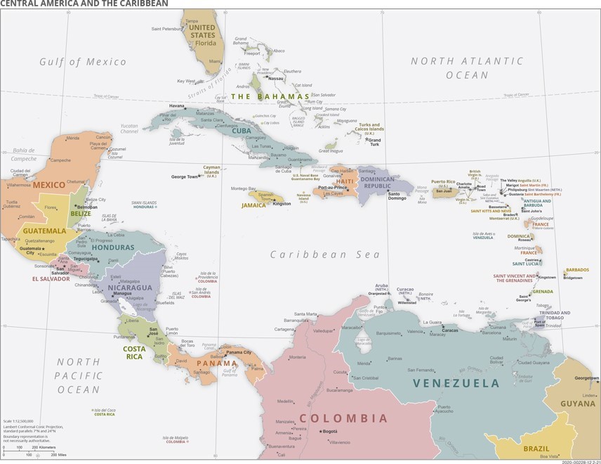
Latin America
Maps: Outline Countries, Region Outline, South America CIA, C. American & Caribbean CIA
The region: Everything south of the US border including Mexico, Central America, the Caribbean islands, South America.
Sub Regions: There are fewer countries in the region so I add these: Greater and Lesser Antilles, Leeward and Windward Islands, Galapagos Islands, Falkland Is. Tierra del Fuego, Straits of Magellan, Galapagos Is., Falkland Is.
Additional cities:
Manaus, Brazil
São Paulo, Brazil
Buenos Aires, Argentina
Rio de Janeiro Brazil
Bogotá Colombia
Lima, Peru
Santiago, Chile
Belo Horizonte, Brazil
Salvador, Brazil
Fortaleza, Brazil
Cali, Colombia
Medellin, Colombia
Monterrey, MX
Guadalajara, MX
Ciudad Juárez, MX
Tijuana, MX
Oaxaca, MX
Nuevo Laredo, MX
