2 Systems of Location
Location
Cameron McCormick
Chapter Goal:
Explain several systems of locating points on Earth
INTRODUCTION
Recall that the three key concepts of geography are distance, direction, and location. Geographers have developed several approaches to most effectively communicate those concepts. All three concepts are embedded within each system. You might think that the purpose of each system is to simply indicated location, in fact each system has direction and distance within it.
You are probably aware of the latitude and longitude system. An advantage of using latitude-longitude is that the concept can be applied to other spheres such as other planets. The concept of direction is easy to see in the latitude-longitude system because you must include cardinal directions when you write the location down. You write N (north) or S (south) for latitude and E (east) or W (west) with the longitude data. Distance, while part of the system, is more difficult for most map users to interpret with the latitude-longitude system because the distance is in degrees, minutes, and seconds which is conceptually difficult to convert into feet, miles, and kilometers.
In this section we will begin with the internationally understood system of latitude-longitude, often called the Geographic Grid then move on to other major systems including the Universal Transverse Mercator (UTM), the United States Public Lands Survey System (USPLSS), and the French Long Lot system. There are other systems used by different organizations, regions, and agencies, but these have the greatest importance in the US. Some of these systems are better and easier to use depending on what data you need.
THE GEOGRAPHIC GRID
Geography is about spatial understanding, which requires an accurate grid system to determine absolute and relative location. Absolute location is the exact x- and y- coordinate on the Earth. Relative location is the location of something relative to other entities. For example, when you use your GPS in your smart phone or car, say Google Maps, you put in an absolute location. But as you start driving, the device tells you to turn right or left relative to objects on the ground: “Turn left on exit 202” is relative to the other exit points. Or if you give directions to your house, you often use relative locations to help them understand how to get to your house.
Great and Small Circles
Much of Earth’s grid system is based on the location of the North Pole, South Pole, and Equator. The poles are an imaginary line running from the axis of Earth’s rotation. The plane of the equator is an imaginary horizontal line that cuts the earth into two equal halves.
This brings up the topic of great and small circles. A great circle is any circle that divides the earth into a circumference of two equal halves. It’s also the largest circle that can be drawn on a sphere. There are an infinite number of great circles, but only one that connects two specific points. The line connecting any points along a great circle is also the shortest distance between those two points. Examples of great circles include the Equator, all lines of longitude, the line that divides the earth into day and night called the circle of illumination or umbral line , and the plane of ecliptic. The plane of the ecliptic is where the sun’s rays hit the surface of the earth at a 90° angle, or straight overhead. It shifts constantly but stays within the tropics and always intersects the equator. A plane flying from Seattle, WA to Paris, France will fly a great circle far to the north over Greenland even though both cities are nearly the same latitude. Small circles are circles that cut the earth, but not into equal halves. Examples of small circles include all lines of latitude except the equator.

LATITUDE AND LONGITUDE
Latitude is an angular measurement north or south of the equator. So 30° north means a point that is 30° north of the equator. Latitude is also expressed in degrees, minutes, and seconds; 360° in a circle, 60 minutes ( ‘ ) in a degree, and 60 seconds ( ” ) in a minute. When you use Google Earth, the coordinate locations are in this degrees/minutes/seconds format, although there is an option for showing only decimal degrees (33.5842°N instead of 33°35’3.12″N). Latitude varies from 0° (equator) to 90° north and south (the poles).
A line connecting all points of the same latitude is called a parallel, because the lines run parallel to each other. Lines of latitude that are 1° apart are always 111km apart. The only parallel that is also a great circle is the equator. All other parallels are small circles. The following are the most important parallel lines:
- Equator, 0° (since it’s the dividing line, there is no north or south)
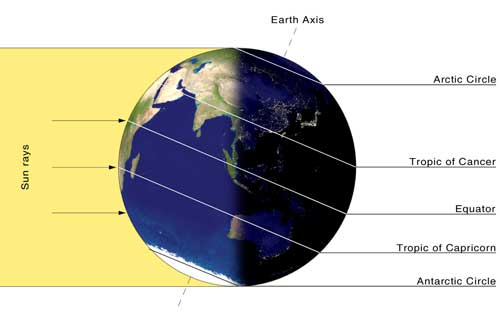
Major Lines of Latitude. The Circle of Illumination or Umbral Line divide the sunlit half and the dark half. It is perpendicular to the Sun’s rays. Tropic of Cancer, 23.5°N
- Tropic of Capricorn, 23.5°S
- Arctic Circle, 66.5°N
- Antarctic Circle, 66.5°S
- North Pole, 90°N (infinitely small circle)
- South Pole, 90°S (infinitely small circle)
Latitude is also sometimes described as zones of latitude. Some of these zones of latitude include:
- Low latitude – generally between the equator and 30°N
- Mid-latitude – between 30° and 60°N and S
- High latitude – latitudes greater than about 60° N and S
- Equatorial – within a few degrees of the equator
- Tropical – within the tropics (between 23.5°N and 23.5°S
- Subtropical – slightly pole-ward of the tropics, generally around 25-30° N and S
- Polar – within a few degrees of the North or South Pole
Longitude is the angular measurement east and west of the Prime Meridian (image on the right). Like latitude, longitude is measured in degrees, minutes, and seconds or in decimal degrees. Lines connecting equal points of longitude are called meridians. But unlike parallels, meridians do not run parallel to each other. Rather they are farthest apart from each other at the equator and merge toward each other toward the poles. At the equator, 1° change in longitude is 111 km in distance, but this decrease to 0 km at the poles. The problem with longitude is that there isn’t a natural baseline like the equator is for latitude. For over a hundred years, nations used their own “prime meridian” which proved problematic for trade. But in 1883 an international conference in Washington D.C. was held to determine a global prime meridian. After weeks of debate, the Royal Observatory at Greenwich, England was determined as the Greenwich Meridian or also called the prime meridian for the world. So today, longitude starts at the Prime Meridian and measures east and west of that line.
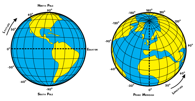
Lines of Latitude are Parallels. Lines of Longitude are Meridians.
|
The proper notation of a point using latitude-longitude is always latitude first, longitude second and the direction (N/S and E/W) is required: 46°N 94.6°W
The range of longitude is from 0° to 180°. The meridian 180° east or west of the Prime Meridian is in the Pacific Ocean. This is a straight line that, along with the Prime Meridian, divides longitude into into either west or east. Most of the line, but not its entire length, is the International Date Line. The date line determines where the new day begins in the world. Now because of this, the International Date Line is not actually a straight line, rather it follows national borders so that a country isn’t divided into two separate days (and we think hour time zones are a pain). On the map below, the International Date Line is to the right in a dark, black line. Note how it is drawn to make sure nations are not divided by the International Date Line.
Time Zones
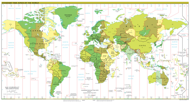
This is also a good time to take a look at time zones around the world. On the map above, see the different time zones are in various colors. Since the earth rotates 360° in a 24 hour period, the earth rotates 15° every hour. In an ideal world, each time zone would follow lines of longitude every 15° (7.5° in each direction from the center of the time zone). Time zones are a human creation, with the purpose of making our lives easier by agreeing on a standard time within a specific region. Daily living is easier within a single time zone so the borders of times zones try to group together regions where people generally conduct their daily activities together. It would be terribly difficult if the time zone borders were strictly enforced and led to a city being cut in half with two different time zones.
Greenwich, England was chosen in the mid-nineteenth century as the starting point of time worldwide. The reason was because at the time, England was the superpower both militarily and economically. So the meridian that ran through Greenwich became zero degrees or the prime meridian. Because of the earth’s rotation in reference to the prime meridian, locations east of the new meridian meant time was ahead while locations west of the meridian were behind in time in reference to Greenwich, England.
The time at Greenwich is called Greenwich Mean Time or GMT. At noon GMT it is not yet noon for locations to west and it is afternoon for locations to the east. If your location is 15° east of Greenwich, you add one hour to the GMT to find the local time. That’s GMT+1.
People have known how to calculate latitude for thousands of years by finding either the angle between the horizon and the North Star or between the horizon and the sun when the sun is at it’s highest point in the sky (solar noon). Longitude was more difficult to determine, but once a reliable clock was developed, it became possible. Ultimately, when you combine parallel and meridian lines, you end up with a geographic grid system that allows you to determine your exact location on the planet. The method for finding your exact location is to determine the angle between the horizon and the sun at solar noon, then check the time on a clock that is set to the time in Greenwich. If the clock says it is not yet noon in Greenwich, but it is already solar noon at your location, then you are east of Greenwich.
UTM (Universal Transverse Mercator)
The UTM system was developed to be faster than the latitude-longitude system. It uses units of meters instead of degrees. This makes determining distances much easier because most of the world knows the length of one meter. The UTM system divides the world into 60 zones, each 6° of longitude in width and extends from 84°N to 80°S. Each zone is cut in half at the equator so zone 15 will have a north half and a south half. As each zone nears the poles, the zone becomes extremely narrow and multiple zones would be needed to get the job done. Moving from zone to zone is more difficult than staying within one zone, so the system resets near each pole. Few people spend time in these areas, so the emphasis of the rest of this section will be the main regions.
| Each UTM zone in the northern hemisphere starts its northing value at the equator and stops at 84°N. UTM zones in the southern hemisphere start 10,000,000 m south of the equator and increase as you get closer to the equator. The first 10° of latitude (from the south pole to 80°S) is not include in standard UTM zones. | 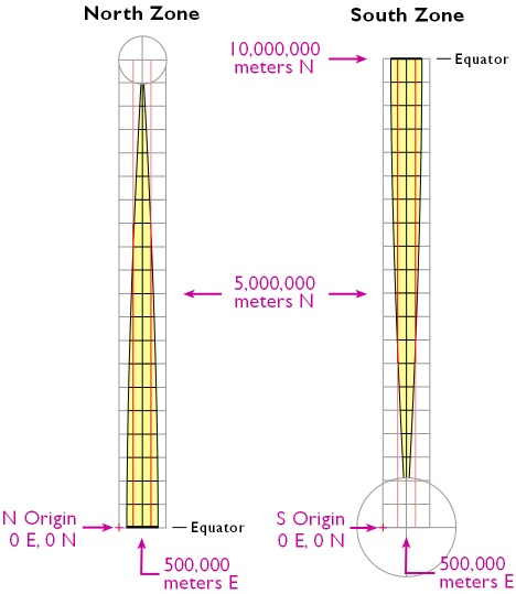 |

UTM coordinates are written like standard Cartesian coordinates (X, Y). In UTM, the X element is called “Easting” and the Y element is “Northing”. The Easting and Northing distances start at a false origin located on the equator and 500,000 m west of the center of the zone for northern zones. For the southern zones the false origin is 10,000,000 m south of the equator or roughly the south pole. By using a different origin for the north and south halves, the coordinates always have positive values which makes the math much easier. The proper notation for a point on the center line of a zone and 1 km north of the equator in zone 15 is: 500,000 m E 1000 m N zone 15 north. Zone 1 starts at the 180° meridian and zone numbers increase in value to the east.
With very little effort, the UTM system becomes much easier to use than the latitude-longitude system.
USPLSS (United States Public Lands Survey System)
The USPLS system was developed in 1785 to systematize the distribution of lands in the Northwest Territory and was then extended to new lands as they were acquired by the US government. It gives an idea of the importance of land ownership that this system was developed several years before the US Constitution was written. The original 13 colonies already had private lands before the USPLS system was developed so those areas do not use the USPLS. Those lands used a much older system called Metes and Bounds. In the Metes and Bounds systems, boundaries were simply agreed upon by owners or they used landmarks to set boundaries. Often those landmarks were trees or rivers. Imagine the chaos after a fire or flood! The USPLS system reduces this chaos.
The USPLS system divides public lands owned by the federal government into squares and rectangles so the land can be more easily distributed to private citizens. Remember that historically many immigrants came to the US looking to own land which they could not do in their countries of origin. Surveyors set up Baselines running east-west and Meridians running north-south and then measured grids from those starting lines. A single pair of one Baseline and one Meridian might by be used for an area covering many states (from Arkansas to Minnesota) or a small part of one state (northeast Utah).
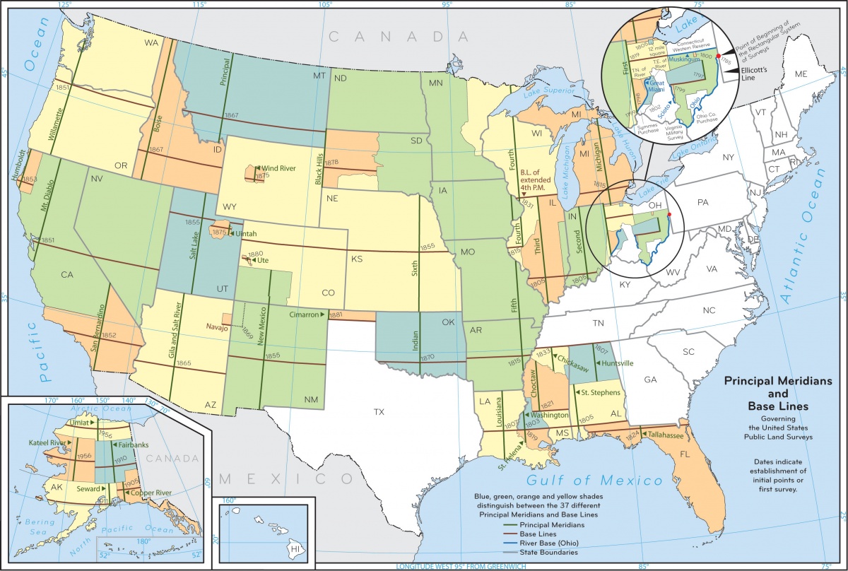
A common name for the USPLS System is “Township and Range” because the largest land divisions within the the system are called Townships or Ranges.
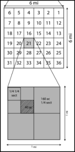
Townships are counted north or south of a Baseline and Ranges are counted east or west of a Meridian. A Township is a unit of land 6 miles by 6 miles (36 mi2) but its legal description requires both a Township number and a Range number. Each township has 36 sections that are 1 mile by 1 mile (1 mi2) which are 640 acres. Sections are always numbered as shown in the diagram.
This system is still evident in American lives nearly every day. A quarter of a section is 160 acres which was the area of land distributed by the federal government in the first Homestead Act. Rural property might be sold in 5, 20, 40 acre units because sections are easily divided into those sizes. The legal description of the cross-hatched area in the figure might be: SE1/4 of NW1/3 of Sect 21 T.21N R 44E Washington. Note how the description starts at the smallest area and ends in the largest area.
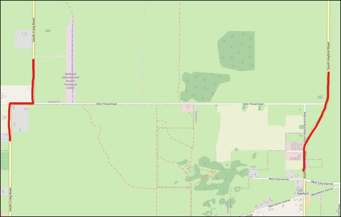
Today as you drive along a paved country road it probably follows the line between two sections or townships. After driving a few miles the road bends then continues straight, or it may stop, forcing you to turn and drive a few hundred feet and then turn again before you can continue in the original direction. The bend or the stop-and-turn is because you changed townships and the original surveyors reset the starting point of the new township to reduce error. Hayford Rd., a busy road south of Airway Heights, WA bends as it crosses into a new township at Thorpe Rd. Craig Road is less traveled and has two right-angle turns.
If you fly over Kansas and see irrigated fields, each irrigated circle occupies a quarter of a section. City and county planners also use the system. In large cities the major roads are often on section lines or half way in between.
French Long Lot
All of these systems of location are designed to help humans understand resources that humans use. Sometimes the scale of the resource is the entire Earth and the latitude-longitude system is very good. Sometime the resources is land, so the USPLS system was developed. In some areas settled by the French they realized that land is important for production, but water is critical for getting the harvest to market. In these areas, parcels of land are often long and skinny and nearly all the parcels meet a river. This is again a carry over from France where a person could only use river water if they owned land adjacent to the river. To give the greatest access to the river, the parcels became skinny but extended far from the river.
Points or Areas?
Finally, notice how both the latitude-longitude system and the UTM system both bring you to a point. The USPLS and French Long Lot systems each locate an area, not a point.
